sandbox-taking-action-with-maps
Most up-to-date published wiki with this material here: https://publiclab.org/wiki/advocacy-with-maps
Mapping offers a way to share and create knowledge about a place. Making a map to document and describe a local issue is often a helpful first step in community science because it can be done collaboratively, represent all kinds of information—from environmental pollution to cultural resources—and show what people close to the issue already know.
Maps are a helpful communication tool in community organizing and advocacy, and you might want to create a map for specific purposes or to communicate with specific people. On this wiki page, we’re collecting some of the different ways that you can take action with maps.
And while thinking about goals for mapping, we can also understand that the process of mapping and the map created represent much more than a communication tool for a specific purpose. Making a map builds a connection to a place! And even with a purpose in mind, a map might start off documenting a location and showing neighbors what’s there, while ending up being used as a tool to communicate with governments and change policies that affect many more people.
Follow along and get updates on this topic by following advocacy-with-maps
Please add to these resources by editing this page, adding and answering questions below, or adding your own activity or story!
- Getting started activities: defining advocacy goals, figuring out where to map, and how to choose a mapping tool
- Tools and methods for DIY mapping: aerial photography, other ways to map
- Examples of how to use maps and aerial images for organizing and advocacy
- Activities on advocacy with maps
- Questions from the Public Lab community
- Additional references and resources
Getting started activities
It can be helpful to start a mapping project by thinking and talking about what you want to make a map of, why you want to map a particular place, and who the map will be for. What new information do you wish to provide with a map?
The resources and activities below offer some ways to get started with answering these questions before you start gathering equipment and tools for mapping.
Defining advocacy goals
For any community science project, it helps to start with determining your goals. This will help you figure out which smaller steps to take to achieve your goals—in the case of mapping, your goals might influence whether you capture your own aerial images to make a map or use existing maps to build upon.
Posts tagged with start-advocacy will appear here

Making a power map at the start of your advocacy campaign
Post by @julia_e_masters 1 | over 3 years ago


Below in the section called “Using your maps and aerial images,” you’ll find more information on using maps for specific purposes or audiences.
Figuring out where to map
If you can, visit the site or talk to people who live there. If you plan to do balloon or kite mapping, look for potential sites to launch or fly from, and check wind and weather patterns at the site.
Posts tagged with where-to-map will appear here


How to choose a mapping tool
How to decide on a tool for mapping: for capturing your own aerial images, this activity includes information on open DIY methods for balloon, kite, and pole mapping, and when each tool works best and their limitations.
If you’d like to use existing maps and digital tools to create maps, rather than capturing your own aerial images, check out the section called "Other ways to map" below.
Tools and methods for DIY mapping
Aerial photography
The wiki pages and posts listed here are rich resources on how to capture your own aerial images of a place. By capturing your own aerial images, you get the most current information on the exact location you’re interested in.

Aerial photography wiki
Organizes information on balloon mapping, kite mapping, and pole mapping, as well as activities and questions on aerial photography. Within the balloon, kite, and pole mapping wikis, you’ll find information on how to assemble and use these different mapping tools.

How to map wiki
Written as a workshop, this wiki describes 3 activities that’ll get you mapping: 1) decide on which type of mapping you will do, 2) prepare your mapping materials, and 3) go map!

MapKnitter wiki
Information on MapKnitter.org, Public Lab’s free and open source software tool for combining several aerial images into a map that you can view online and print.

Host a balloon mapping workshop
Map with other people! This activity outlines how to get people together to map.
Other ways to map
- Host a collaborative map drawing workshop: also called “mental mapping,” this activity describes how a community group can use markers and paper to map what they know.
- A Card Game Approach to Community Mapping: this activity by @dbsnp describes a neat way to gather information about a community’s environmental hazards and social risks and map them as a group.
You can also use existing open or publicly available maps if you don’t want or need to capture your own aerial images.
- Green Map System: started by @WendyBrawer, Green Maps and its open source mapping tools enable anyone to create a community map embedded with icons, local stories, and information about ecology and culture. Their latest platform, OGM2, is here: https://new.opengreenmap.org/
- OpenStreetMap: open maps contributed and maintained by a global community.
- Aerial Imagery in the Public Domain
Using your maps and aerial images
You might want to use your maps for specific purposes or to communicate with specific people. To help illustrate some of the many ways maps can be used for advocacy, we highlight some of the different ways that maps can be used below.
While thinking about goals for mapping, we can also understand that the process of mapping and the map created represent much more than a communication tool for a single purpose. Making a map builds a connection to a place. And even with a purpose in mind, a map might start off documenting a location and showing neighbors what’s there, while ending up being used as a tool to communicate with governments and change policies that affect many more people.
General information on advocacy and maps
Wetlands advocacy wiki: this wiki is part of the Wetlands Toolkit, but outlines a workshop and general information on some different advocacy goals and the ways that community-collected aerial maps can support those goals.
Annotating maps
Putting words, arrows, and drawings on a map can help explain and illuminate what the map shows.
How to make your own community annotated map!: a step-by-step activity on making annotated maps by @julia_e_masters.
See what’s tagged with annotated-maps on Public Lab here: https://publiclab.org/tag/annotated-maps

Image: annotated map of Bayou Manchac sewerage problem, from this post by @eustatic
Maps to guide environmental monitoring and study design
Examples:
- Hydrogen Sulfide Photopaper Sensing Tool - Development Notes: @ewilder placed photopaper-based tools near oil and gas developments in Wyoming to detect hydrogen sulfide emissions. They mapped these locations onto an aerial image alongside initial test results from the photopaper (slide 15 in presentation in the linked research note)
Images from this research note by @ewilder, showing an aerial map of locations where photopaper is darkened by hydrogen sulfide.
Maps to raise awareness or start a campaign
Examples:
- Documenting the 2010 BP oil spill with aerial photographs (42 minute-mark of the Crowd & the Cloud episode 1), and the subsequent Barataria Bay Mapping Project
- Monitoring East River Park in New York City with an open Green Map
Maps to tell a story about or understand a place
Examples:
- Decolonized Skies: by @hagitkeysar, an exhibition featuring research and maps
- Grassroots Mapping in Butte Goes Analog: by @mathew, putting a map of a city up in a community space and seeing what residents mark down
- Exploring The Space Unseen: Historic Resources For Guiding Future Story Telling: by @eymund
- Lessons from mapping Bourj Al Shamali refugee camp in Lebanon: by @clauds, @Amal, @firas, @mustafa10, and @Mustapha, and a case study on this work, "Community Mapping to Reevaluate Space in a Refugee Camp" by @gretchengehrke
- Tribal Intertidal Digital Ecological Surveys (TIDES), by @RosaL
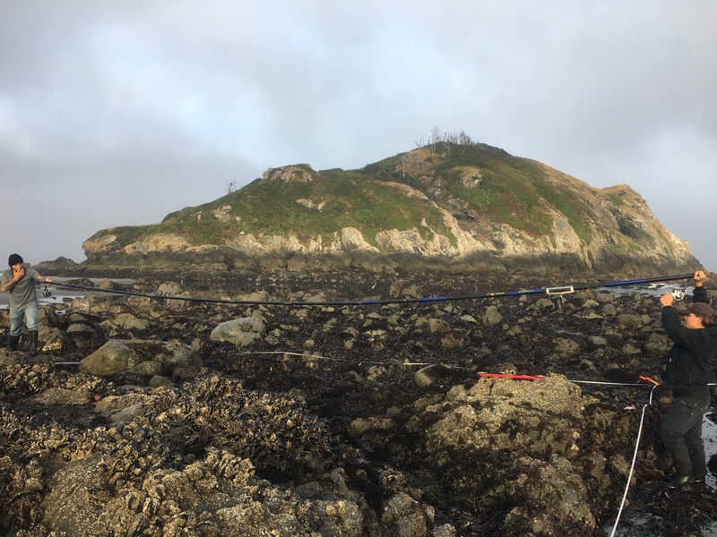
Image: a form of pole-mapping to capture images of rocky intertidal shorelines for the TIDES project, described in this post by @RosaL
Maps for communicating with or reporting to government agencies and representatives
Examples:
- Compile screenshots and URLs for aerial images of Harvey damages in a spreadsheet for reporting: from the disaster response to Hurricane Harvey
- Basic needs for imagery reporting
Maps as evidence
Examples:
- Enforcing Stormwater Permits with Google Street View along the Mystic River
- Kite Photo of Ongoing Coal Pollution in Plaquemines Parish, LA
- Case Study: Using Aerial Imagery to Pressure Industrial Polluters into Stormwater Compliance

Image: balloon mapping water flow in the Gowanus Canal with the help of red food dye, from a comment in this post by @eymund
Activities
Activities on Public Lab tagged with activity:advocacy-with-maps will appear here
| Purpose | Category | Status | Author | Time | Difficulty | Replications |
|---|---|---|---|---|---|---|
| Making a power map at the start of your advocacy campaign | - | - | @julia_e_masters | - | - | 0 replications: Try it » |
| How to ... make your own community annotated map! | - | - | @julia_e_masters | - | - | 0 replications: Try it » |
Activities should include a materials list, costs and a step-by-step guide to construction with photos. Learn what makes a good activity here.
Questions
Questions tagged with question:advocacy-with-maps will appear here
| Title | Author | Updated | Likes | Comments |
|---|---|---|---|---|
| Nothing yet on the topic "advocacy-with-maps" -- be the first to post something! |
Additional references and resources
- Mapping Our Common Ground Guide: comprehensive guide on community mapping, including examples from around the world and workshop ideas.
- Maps for Community Organizing: from the Advancement Project, this guide explains how maps can be used in community organizing, especially when planning a campaign.
- A brief introduction to critical cartography, the idea that “...[m]aps reflect and perpetuate relations of power…” by Rhiannon Firth in The Occupied Times.
- “Community Mapping” resources listed on pg. 32 of River Networks’ Tools for equitable climate resilience--Fostering community-led research and knowledge.