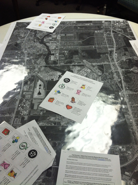
Creating an annotated map of your community can be an accessible way to connect deeper to your surroundings, and help to understand your neighborhood, region, or network. Annotations are drawings, arrows, or words placed on the map that highlight or further explain what the map shows. By working locally, this can also be used to advance local advocacy goals, collect data on particular metrics, and more.
Materials needed
- If making a digital annotated map: a computer with internet access, printer
- If making a physical annotated map: printed out map, writing utensil
Step 1
Create a baselayer map to start with
- Create your own custom baselayer map by capturing aerial photos of the place you want to map. Learn more about how to do this on the aerial photography wiki page
- Use existing online tools to create a digital baselayer map. Example tools include OpenStreetMap and Green Map
Step 2
Gather as a group and determine your goals for an annotated map (see examples here)
- What are the goals you want for this map? Will you use it to test a hypothesis? Will you use it for local organizing? Using community maps can help folks feel more connected and responsible for their neighborhoods. Think about what this map could help illuminate! See this example of how to learn from past and current land use.
- Consider hosting a community meeting:
- Steps for hosting an event: https://publiclab.org/wiki/host-an-event
- Example of community meeting goals: https://publiclab.org/notes/kgradow1/09-26-2020/host-a-community-meeting-to-discuss-your-air-sampling-goal
Step 3
Use drawings, arrows, words, and icons to represent things we know and what we have. Here's some example ideas of "what we know":
Where we live/donde vivimos (apartments, homes, shelters, etc/ apartamentos, casas, refugios, etc)
Where we play/donde jugamos (parks, recreations centers, etc/ parques, centros de recreacion, etc)
Where we workshop or pray and places that are sacred/donde rezamos y sitios sagrados
Where we learn and study/donde aprendemos y estudiamos (schools, daycares, libraries, etc/ escuelas, bibliotecas, guarderias, etc)
Other places we want to protect and strengthen/otros lugares que queremos proteger y fortalecer (community centers, police and fire stations, etc/ centros comunitarios, estaciones de policia y de bomberos, etc)

Annotated Map Examples:
- San Antonio Equity Map
- Green Maps icons
- Galenda Park Community Treasure Maps
- Balloon Mapping
- Bayou Annotated Map Design
- Bayou Sewage Annotated Map
Power tag: notes:annotated-maps
Wrap Up
How did this exercise help you understand your surroundings? What new ideas or questions do you have about your community? How might you use this map in your personal or professional life?
2 Comments
@eustatic @mathew @eymund check this out -- an activity for annotating maps. Would love to hear from you with ideas and approaches --
Reply to this comment...
Log in to comment
@denissebn_06 check out this resource!
Reply to this comment...
Log in to comment
Login to comment.