The Public Lab Blog
stories from the Public Lab community
About the blog | Research | Methods

Interview with Pat Popple
Interview by Stevie Lewis for Community Science Forum: Sand-Frac Issue.
What initially sparked your involvement with the frac sand issue? When the frac sand mines and processing plants came to our city and county, I became cognizant of the injustices occurring to people living near the locations. When government officials did not listen, I spoke up. The result was the formation of Concerned Chippewa Citizens.
What is your biggest concern around the issue? I have many. It’s a convoluted industry with many components, so it’s difficult for people to unwind them all. The health, safety and welfare issues have not been resolved. There has been very little effort by the industry to directly research these issues. Silica is carcinogenic. The jury is still out on the long term impacts of the respirable crystalline silica particles on life near the mines. The potential could be huge. Little is known about the long term impact on water quality and quantity around these facilities that will assure that citizens will be healthy and safe over the long term.
Over the years there have been a number of monitoring efforts that community members have worked on. What have been some of the biggest accomplishments and some of the biggest challenges?
Dylos monitors set up by Hank Boschen and others who purchased their own equipment was an ingenious idea. The collection of that data and visual monitoring located at several sites around the county was critical to show that there were particulates in the air. This preliminary work alerted the sand companies to the fact that we were watching, and while speciation [identification of the type of dust] was not a part of the study, particulates were registering and viewers could see them fluctuate based upon wind changes and activity at the mine and processing sites. When Jeff Falk from Fountain City analyzed the data, it became obvious there was concern. EOG Resources then hired an industrial scientist, but one study of short duration is not enough. Before we know people will be safe, we must understand the cumulative impacts of these operations, yet people and animals are exposed to these operations daily.
Initially there was a lot of interest in dust/silica and now it seems a lot of attention is given to water issues, what do you think sparked this?
There is still a great deal of attention in terms of air quality measures although the mining operations try to assure us that there is no danger. It’s very difficult to know the long term impact of air quality on a human being or animal.
There has been an increasing concern on the water issue because, finally, one of the DNR folks came out with the concern that there was a case for leaching. Now we are learning more about the sulfides, low pH, and oxidation, all of this helps to get the heavy metals into the water. It’s an issue of quality over the long haul and the impact, safety.
What advocacy strategies have you found to be effective in your effort? Having started eight years ago, I think we have tried every strategy that we could possibly come up with. It is critical that people stick together, work together, strategize and support each other, attend meetings, learn more, and speak with informed minds. Governmental officials must learn that citizens have done their homework and that fossil fuel industries are notorious for duping the innocent. It is powerful for citizens who have studied the issues to attend a meeting and challenge information spread by the companies.
You’ve been speaking with a number of other groups who also deal with the struggles of extractive industries. In growing your network, what have you learned?
People in many parts of the country have mutual concerns. We in the Midwest have a link to is happening here and in other areas where hydraulic fracturing is happening. Pipeline issues, tar sands extraction...all are tied to the extreme energy extraction issues. Noise, trucking, rail, tanker bombs, export concerns affect us all. It’s part of this whole big system. We have to quickly make a paradigm shift in the way we regard energy if we are to survive.
What is one thing you wished you knew when you started this fight?
I wished I knew more about was how long it would take. Eight years of my life have transpired, and almost every day I’ve worked on this. It’s a long time to work on an issue to have it not resolved. However, the time spent has opened up new learning, teaching and organizing opportunities. The concern has spread and it is great to see so many others involved all over the world on energy and climate issues that started out for me with the intrusion of a silica plant in the City Limits.
What is something that has gotten easier and something you continue struggle with? Making connections with people who have common concerns has made it easier, but there is a need for educating and networking with more who can make a great difference. It is critical that voices are heard and that decision makers learn to say “NO” to the intrusion we are facing and the conditions we are creating for future generations. Empowering people to do that is a struggle!
Any words of advice for people who are starting to face extractive industries in their communities?
Get involved; sustain the effort and don’t give up! We have a long way to go, but people can change and move to other forms of sustainable energy use. Hope for a better life for many is critical, and our young people must become involved and use their creative, critical thinking and problem solving skills to create new ways of living before we make this planet uninhabitable.
Is there anything you want to share out with people who will read this publication? I think it’s important that we persevere, show great determination, use our voices and make it known to our government officials that we want to be participating in our local, state and national government. The power of big industry and corporations must be reined in. All citizens have to be willing to accept and/or work toward making change to improve the living conditions for all people now and into the future so we can collectively live on this planet.
Photo credit: Julie Strupp/Wisconsin Center for Investigative Journalism
Follow related tags:
wisconsin blog frac-sand with:stevie

What happens when the mining stops? Focus on Reclamation
Article by Gretchen Gehrke, Mathew Lippincott and Cheryl Miller for Community Science Forum: Sand-Frac Issue.
“Our major concern is, if they just walk away whose shoulders does reclamation fall on? The town, the landowner, or the county?”
Reclamation is the process of preparing land for another use after mining activities cease. Prior to granting a permit to operate a mine, the county must approve a “reclamation plan” including land’s post-mining use. Many communities are concerned that typical reclamation plans will leave lands significantly degraded compared to their pre-mining state and unprepared for beneficial uses consistent with local land use plans.
Many mines were forested hillsides before mining, and will be flatter land after reclamation. Sustaining plant vitality after reclamation can be difficult, especially if the reclamation plan includes such soil intensive uses as agriculture. During stockpiling of the overburden layers (soil on top of the mined bedrock) soils rapidly degrade, and may take decades to centuries to re-develop1. In the meantime, mines in the process of reclamation can have significant erosion problems, be hosts to invasive species, and promote groundwater seepage at the base of reclaimed piles. This seepage could introduce surface and groundwater quality concerns such as mobilized heavy metals in oxidized and acidified soils.
In addition to environmental concerns around sand mine reclamation, communities also face economic concerns. To discuss some economic concerns, Mathew Lippincott spoke with Cheryl Miller, president of Save The Hills Alliance, a nonprofit organization dedicated to protecting the natural environment in western Wisconsin. Mathew and Cheryl’s conversation is transcribed here:
Between ¹⁄3 and ½ of all frac sand operations are paused but you’re still concerned2. What issues are still active?
Even though they aren’t actively working the mines there are still huge piles of sand and holding ponds. We don’t know if those are being maintained, but the companies seem to only respond to complaints. Our major concern is, if they just walk away whose shoulders does reclamation fall on? The town, the landowner, or the county? We don’t know, and there are legal loopholes that could leave us footing the bill as taxpayers or fighting expensive lawsuits as a town.
How did you get involved, and long have you been concerned about the mines?
I’ve been involved in opposing frac sand mine expansion since 2005, when the Hoffman Hills mine was proposed to go in across from the site of our future home. We were not yet living there as we hadn’t built the house we were planning, but we received no notification from the town or county that a large mine was proposed. We formed a coalition and successfully opposed the mine. Different members of the coalition were concerned with the neighborhood, the mines’ position next to Hoffman Hills state park, and the mine’s proximity to Muddy Creek. A group called Save Our Hills came out of the effort, and a few years later we joined with other groups to form Save The Hills Alliance. After all that I thought, if I can get on the local board to be town clerk, maybe this wouldn’t happen to other people.
Frac sand operators came in with promises of increased revenue for towns and counties, how has that worked out?
The boom/bust cycle has brought temporary income that may never cover the cost of having mines. Here in Tainter Township, Fairmount Minerals is over a billion dollars in debt and has laid off 55 employees locally. We have no idea what will happen. We only collect approximately $10,500 in taxes from them each year and aren’t relying on the mine’s income, but many towns have planned around the income from mines. Chippewa Falls has a Tax Increment Financial District supporting downtown improvements based on their real and personal property taxes from EOG. Blair township has payments reserved for their school district, and a lot of counties and townships have a ‘wheel tax’ or production tax of 10-15 cents a ton. When the mines close they won’t get that, and if they planned around these taxes they could be in trouble. You mentioned that you’re concerned about a legal loophole that may let mines escape accountability, can you say more? We are still determining if a legal loophole in NR 135.40 will allow banks to cancel the reclamation bonds when they see an impending bankruptcy.3 While the intent of the law is to allow a company to change bonds, the wording may allow a bank to cancel the bond with 90 days notice, and if the mine doesn’t shut down operations, county officials wouldn’t be able to prove the company had failed to reclaim. There’s no case law on the statute and we could face an expensive lawsuit.
How do you plan to keep attention on the mine? What needs to be done?
Monitoring these mines is important to keep the pressure on. In Augusta complaints have kept the mining companies watering their piles so dust doesn’t blow off site. We need to get pictures not just to keep the mines honest, but also to bring attention to the fact that even though they aren’t operating, we’re still being affected.
References
(1) See a summary here:
http://conservancy.umn.edu/bitstream/handle/11299/59360/4.7.Strohmayer.pdf?sequence=1
(2) December 2015: DNR says 84 open, 40 closed facilities. http://dnr.wi.gov/topic/Mines/ISMMap.html
June 2015: Midwest Energy News lists 58 inactive and 63 active mines. http://midwestenergynews.com/2015/06/03/wisconsin-towns-worry-frac-sand-boom-will-dry-up/
(3) http://www.wpr.org/officials-frac-sand-companies-could-exploit-loophole-avoid-filling-mines
Follow related tags:
wisconsin mining blog frac-sand

PL with FA @ Venice Bienalle
I have had a really huge opportunity to join the work of the curator Debby Farber from the Israeli organization "Zochrot" and Eyal Weizman of Forensic Architecture that concerns the ongoing displacement of the Bedouin village of al-Araqib in the south of Israel. Together with Ariel Caine - who is an artist and researcher in Goldsmith's Center for Research Architecture at Goldsmiths - we have worked with a few totally inspiring and resilient activists, Aziz al-Turi and Nuri al-Uqbi, from the village in creating kite and balloon aerial photography, which were processed by Ariel into 3D models, with the intention to produce vivid aerial testimonies of systemic violence and abuse of human rights. This work is now presented as part of Forensic Architecture's projects in the Venice Bienalle (The International/Italian Pavilion in the Giardini and the V&A Cast Courts at the Arsenale). There are four cases presented by FA, the investigations include 1) the drone strike in Miranshah, Pakistan March 30, 2012, 2) Israel's attack on Rafah/Gaza August 1, 2014, 3) the lethal effects of the EU 's policies of non-assistance in the central Mediterranean 2014-2015, and 4) displacement and environmental destruction along Climatic Frontiers al-Araqib/Palestine and Wede'rã/Brazil 2016. Above, the main image shows a sparse point cloud created by Ariel based on one of the kite/balloon surveys we conducted in the area of al-Araqib in last April.
Below you can see one of the light tables created by FA people, the one representing the forth case that includes the use of Public Lab's DIY aerial photography. It is high resolution, if you click the image you can see details.

The forth case was also presented in a 30 minutes film, by Armin Linke, Alina Schmuch and Jan Kisswetter, from which I have extracted some image, below.
In the film, Eyal presents the two cases in Palestine and Brazil - two zones, two villages, one at the northern threshold of the Sahara, crossing Israel-Palestine and the other at the southern amazon area. In Palestine, it is a case of afforestation in order to push the desert and displace its inhabitant, while in Brazil it is the line of the forest which is being cleared to make agricultural fields. "In both we have native people that are being displaced".
This image was taken while doing kite photography in the southern Amazon. As described by one of the researchers*, this area is going through processes of slow violence through "gradual degradation and destruction of the forest for logging, fire and conversion to pasture land and plantation". These intervention are "destroying the very condition of modes of lives that rely on the forest and sustain the forest itself and the people who live in it. The killing of the forest is the killing of the people. Killing of people is also the killing of the forest."

The image below, which was taken with a kite and a go-pro camera, captured the entire extent of the village. "You can see a small village of about ten homestead, it is a kind of a forest clearing within that area. It allows to start looking for those villages that has been destroyed and displaced. If you measure and take the form of the village you can start looking for the places that were destroyed from other parts of the forest.

The images below are showing the stitched aerial photograph we created and a moment during the flight of the kite camera in al Araqib.


- Apologies, the names were not mentioned in the draft version of the film which I watched.
** Thanks for Ives Rocha and VJ pixel of Public Lab for assisting in figuring out logistics for carrying out the balloon and kite aerial photography in Brazil.
Follow related tags:
balloon-mapping kite-mapping 3d brazil
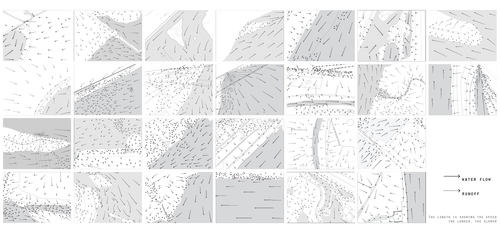
Public Lab River Rat Pack -- St. Louis – Xiaoqing Qin
Have been in St. Louis for three years for my master of landscape architecture in Washington University, it is Derek’s Public Lab River Rat Pack class for the first time that gave me such a series of site visits systematically along the rivers and the water system around. The large number of aerial photos from our balloon/kite flies in different angles amazed me: there are so many details I have never noticed in and along the rivers before when I was looking at aerial photos from other online sources like Google Earth for my other projects, and I think the accumulation of those details are shaping the landscape and will make a big difference for us to understand how the influence of water on our living environment.
I started to document my own observation by creating the water flow diagrams generating from aerial photos, collaborating with students diagraming vegetation and water infrastructure. These water flow diagrams are my personal interpretation of the direction and velocity of both the river water and the storm water, which I regard them as a work in-between science and design. There is the beauty of the natural water flows, shaped by Mother Nature’s geology millions years ago, which is quit missing in our urban landscape today. The next time if recreating any waterscape in the urban context, maybe we will have inspirations from here. There is the warning of human occupation at the riverfront. The flood is ruthless to anything in front, no guarantee our flood-preventing facility can work every time. At the same time, the increase of impervious surface and channelized riverbed in urbanized area keep adding power to the storm water. There is the ecological value behind, where water slow down, curve back and deposit, the sediment and nutrient create small refugees for certain plants and animals.
In the end, I want to appreciate the opportunity to work with students of science background and other design disciplines, and meet different people in the community. I learned a lot from you and I am proud we have such a wonderful exhibition with everybody's work together. I hope there will be more other engagement to keep the project going in the future.
Follow related tags:
balloon-mapping blog mississippi-river mid-west
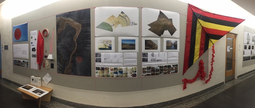
Public Lab River Rat Pack -- St. Louis -- Exhibition
Since January, 2016 the Public Lab River Rat Pack (led by Architect and Assistant Professor Derek Hoeferlin) has documented multiple river edge conditions in the St. Louis, Missouri region, near the confluence of the Mississippi and Missouri Rivers. Some map the difference between high and low river stages; others map the intensity of industrial uses along the rivers; others map more ecological areas; and, all question the profound lack of access by the public to the rivers. Hoeferlin led a seminar at Washington University in St. Louis that included undergraduate and graduate architecture, landscape architecture, urban design, construction management and earth and planetary studies students. The work is ongoing, and we are looking forward to collaborate with others in St. Louis, and beyond. The exhibition of the work will be on display in Givens Hall at Washington University though mid-May. More posts are forthcoming from the students including more in depth explanations of findings from each site and the process of collaboration with the community. Thanks to Public lab, Washington University, the US Army Corps of Engineers, Audubon Institute at Riverlands, and others, for the time and support!


Follow related tags:
balloon-mapping blog mississippi-river barnstar:basic

Highlights: Working with Communities in the DIY Oil Testing Booklet
The second section of the new DIY Oil Testing Booklet, which we’re highlighting this week, is focused on Working with Communities.
In this section, you will find four workshops ready to help you lead a group through:
- designing an experiment
- building a spectrometer
- calibration and scanning
- finally analyzing your results
Check out the workshops here:
Workshops
- Workshops overview
- Workshop 1: Design an experiment
- Workshop 2: Build a spectrometer
- Workshop 3: Calibration and scanning
- Workshop 4: Analyzing and sharing
To highlight #1:
The Design an Experiment workshop can be used for anyone who is interested in conducting experiments which make use of the scientific method. It will help you work through understanding the capabilities and limitations of data. Participants in this workshop will be able to learn about the elements needed for good experimental design, identify important points of designing a clear experiment, draft questions and transform them into hypotheses, and explored the concept of proof versus likelihood.
This section of the Oil Testing Booklet also explores the nuances of working with both online and offline community members. It provides material on outreach strategies for those working at different stages in projects. It explains how Public Lab run an online program for people to helped identify and to show the ability and limitations of the Oil Testing Kit through replication.
For those interested in community tool development, another section in this chapter explores the new concept of “Open open hardware” -- a reference to the fact that many “open hardware” projects are developed in private and only published openly upon completion. By contrast, the process we’ve proposed and begun to adopt is one where the goals includes things like:
- low barrier to entry for new contributors
- predictable revision timeline
- regular iteration and feedback on proposed changes to help them get prepared for the next release due date
- a single, consistent, versioned, "baseline" design for the project, emphasizing simplicity & low cost, but upon which advanced mods may be made
Learn more about the workshops, the programs and ideas explored in this project with the Oil Testing Kit Booklet:
Order here ($10 paperback)
Follow related tags:
spectrometer community workshops blog