Balloon & Kite Mapping
Purpose
This tool is being developed to provide a low cost, easy to use, and safe method for making maps with aerial images. Over the last two years, we’ve built a global community of mappers who are engaged in discussion around the development and use of this tool and others. Normally aerial maps are made from satellites and airplanes. This activity introduces easy methods for making on-demand maps. Our community is particularly interested in applying this to civic and environmental issues.
Browse maps and data generated with this technique in the Public Laboratory Archive
Aerial Mapping Toolkit
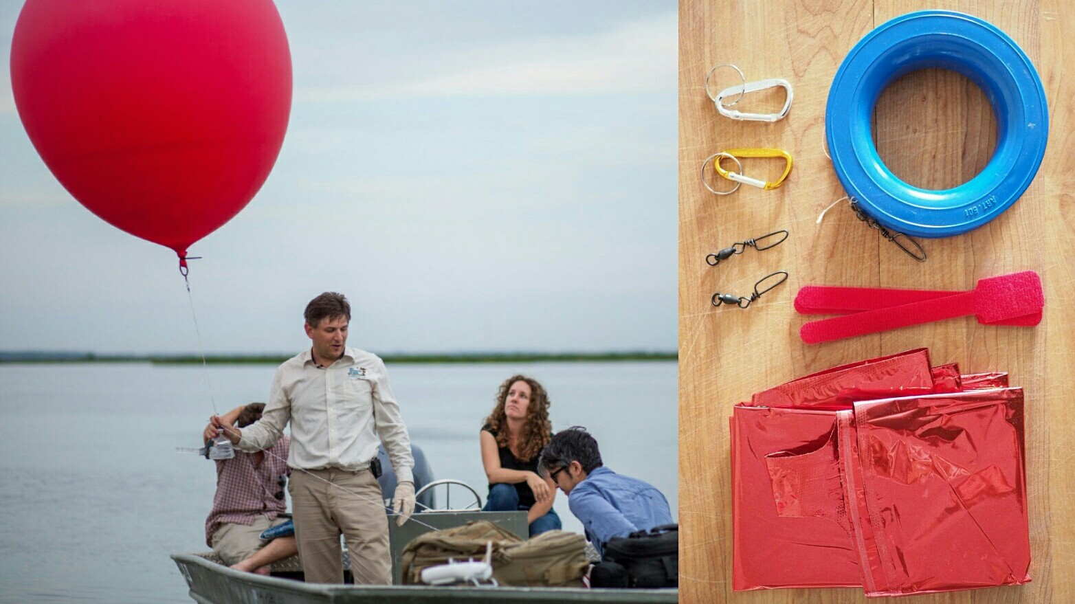
Our aerial mapping toolkit is a simplified kite and balloon aerial photography system for easy and accessible high-resolution map-making. The tookit consists of:
1 Flight platforms: Assembling a balloon kit will cost from $100-200, including helium. The Public Laboratory [Balloon Mapping Kit] assembled from our prefered parts contains a 5.5' (170cm) reusable chloroprene helium balloon, hoop winder, 1000' (300m) braided kite line and a lot of useful small hardware. [balloon mapping kits] For alternative and low-cost materials, see the Balloon Mapping Materials page. For kites, see Kite Mapping
2 Camera housings: PET Bottle & Rubber Band Rig wraps around the camera for protection while firmly mounting it in a position for vertical mapping images. soda bottle camera house
3 Cameras that supports continuous shooting mode or video with a large storage card camera selection camera trigger
4 Mapmaking software: A means of image sorting either on your desktop, or using Mapmill
Public Laboratory's MapKnitter, browser software for map making. or pay software such as Photoshop, Hypr3d, or PhotoSynth
5 Useful guides: Our latest guides can always be found on the Guides page. including the four-page Grassroots Mapping Guide, The Balloon Mapping Quick Start Guide to filling and flying, and The Balloon Mapping Check Lists, which are extremely useful in planning field expeditions, even for experienced fliers. We also maintain a guide to FAA regulations page.
6 Curricula and workshops
Applications and Example Uses
Residents of the Gulf Coast are using balloons and kites to produce their own aerial imagery of the Deepwater Horizon oil spill… documentation that will be essential for environmental and legal use in coming years. We believe in complete open access to spill imagery and are releasing all imagery from the oil spill mapping project into the public domain. Browse maps and data from the Gulf Coast and elsewhere in the Public Laboratory Archive
Advanced Techniques
- near-infrared imagery for vegetation monitoring and other uses.
- Image analysis - Try some of these techniques for bringing out detail and compositing your images with near-infrared imagery.
- Ground control point yargets for correlating on-the-ground measurements directly with photos.
- Balloon telemetry for recording GPS and gyroscopic data.
- [Kite Balloons](/tool/kite-balloon-hybrid- experiments in wind-stabilized balloons
- Hydrogen ballooning - be very careful!
Get Involved
- check out our community blog
- Join our mailing list
- Post research notes to our site.
- tag your photos publiclaboratory and grassrootsmapping on Facebook, Flickr, etc.
- contact our team directly. be sure to mention: the coordinates of the site context; what you'd like to use the data for
Places to start contributing
- Curriculum-Guide
- Balloon Mapping Materials
- Any of the Advanced Techniques (above)
- MapKnitter.org