### About Open-weather is a collective experiment in imaging and imagining the earth and its weather systems using DIY community tools. Co-led by @sophied and @sashae, Open-weather probes the noisy relationships between bodies, atmospheres and weather systems through amateur radio, open data and intersectional feminist approaches to environmental sensing. Open-weather encompasses a series of how-to guides, critical frameworks and public workshops on the reception of satellite images using free or inexpensive amateur radio technologies. When possible, we work with open source software and hardware. Beyond Public Lab, the [Open-weather web platform](https://open-weather.community/) hosts an emerging archive of amateur radio-generated weather images as well as the first Open-weather 'community nowcast' linking 13 citizen ground stations around the world in an effort to engage with the complex relationships between weather and climate change. What do we mean by intersectional feminist approaches to environmental sensing? In Open-weather, we think critically about our 'politics of location' - our different social, economic, historical, geographical and political positions. In doing so we examine how we participate in relationships of power, especially those of white supremacy, in order to better identify and challenge structures of oppression. Through workshops and artistic performances, we bring attention to alternative histories of sensing atmosphere, weather and Earth. We explicitly focus on access to technology and we strive for equity. We ask: who or what gains power from satellite imagery, radio technology, meteorological and climatic data? Finally, we seek forms of sensitivity and responsiveness to the interconnected earth processes that sustain us. ### Location London and low Earth orbit. ### Project history @sophied and @sashae have been working on amateur radio-related projects since early 2017. In 2018 and 2019, @sophied and @sashae collaborated on several public workshops, artworks and writings including the performative script [_Lore of the Radio Fossil_](http://temporaryartreview.com/lore-of-the-radio-fossil/). They designed, coordinated and delivered amateur-radio workshops at the Centre for Research Architecture, Goldsmiths University; the Department of Geography, Royal Holloway University; and the [Royal College of Art, London](http://www.sophiedyer.net/teaching-and-learning/satellite-seance/). In April 2020, they launched Open-weather. From April to December 2020, Open-weather was supported by an interdisciplinary artistic residency at [Akademie Schloss Solitude](http://www.akademie-solitude.de/en/fellowship/fellows/sasha-engelmann~pe4017/), Stuttgart. In Summer 2020 @sophied and @sashae launched the [open-weather.community](https://open-weather.community/) web platform, a central node for the project. [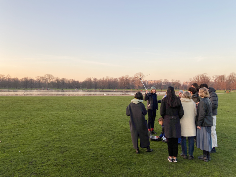](/i/39836?s=o) Open-weather Workshop and Satellite Séance performance at the Royal College of Art, London, in January 2020. @sophied holds the turnstile antenna during the pre-pass talk with @sashae. Photo: Marco Ferrari ### Goals and motivations After @sashae and @sophied got their amateur radio Foundation Licences from the Radio Society of Great Britain it took months of poking around on the web to realise that it was possible to receive weather satellite images, then, more time, searching and hanging out in Ham Radio forums (@sashae is great at this) before they got the right hardware and software setups. Now they’ve done the research and have seen what's possible with inexpensive kit, and they want to share their experience by creating accessible, visually rich how-to guides with everything you need to know to get started, all in one place – without assuming **any** prior knowledge of radio, science or engineering. Goals On Public Lab: * To produce accessible, visually rich and well-documented guides for setting up DIY satellite ground stations for reception of NOAA images. These will be targeted at non-experts (and non-hams). Our hope is that the guides will be useful to curious individuals and practitioners. * To co-author guides that are useful resources for experimental and interdisciplinary teaching and learning at various educational levels. * Discover mutual interests and synchronicities between amateur radio-generated satellite imagery and other kinds of environmental data or projects on Public Lab. On the Open-weather web platform: * To build and maintain a public, amateur radio-generated archive of images and sounds decoded from different satellites, starting from the NOAA fleet, progressing to the Russian Meteor fleet and eventually EU and US-operated geostationary satellites. ### People who are involved Open-weather is a project by UK-based designer @sophied and creative geographer @sashae . The project has been shaped and informed by many others, including: * Bill Liles (NQ6Z) * James Thieman ([Radio Jove/NASA](https://radiojove.gsfc.nasa.gov/)) * Larry Dodd (K4LED) * [Radio Society of Harrow](https://www.g3efx.org.uk/) (G3EFX) * Weather or Not Reading and Listening group * Rachel Dedman, Laure Selys and Arjuna Neuman (Radio Earth Hold) * Daisy Hildyard * The [Soundcamp](https://soundtent.org/soundcamp_reveil.html) 2020 team * The [RTL-SDR Network and Forum](https://www.rtl-sdr.com/) ### What are we currently working on * We are continually working on the [open-weather web platform](https://open-weather.community/) and community archive, initially designed with developer [Piper Haywood](https://piperhaywood.com/). * With the help of the Public Lab community, we are testing our 'DIY Satellite Ground Station' guide (posted in Activities below). * We are developing a series of other accessible how-to guides that extend from the 'DIY Satellite Ground Station' guide and will enable others to further customise and optimise their ground stations. * We are exploring how to make the software ecosystem of NOAA weather data reception more resilient and open source. * We are hosting 1-day public workshops in which participants each create their own DIY Satellite Ground Stations and decode their first NOAA satellite transmission. * We are growing and evolving the Open-weather community network through global weather 'nowcasts' carried out in collaboration with citizen participants at various locations around the planet ### Updates Are you interested in following Open-weather? Subscribe to the tag below to get updates when we post new material. Subscribe to updates on this project [notes:open-weather] ### Questions [questions:open-weather] **** ### Activities we've done in our project [activities:open-weather] ### Data The emerging open-weather archive can be found here: https://open-weather.community/archive.html [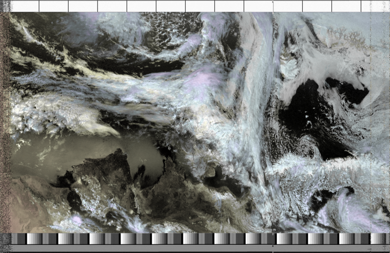](/i/39835?s=o) An image decoded from a NOAA 18 Southbound pass at 49 degrees West on 17th May 2020 at 11-34 BST. Satellite ground station: Burgess Park, South London. ...
| Author | Comment | Last activity | Moderation | ||
|---|---|---|---|---|---|
| github | "Turns out that the rustup I installed via brew wasn't happy. I ran curl --proto '=https' --tlsv1.2 -sSf https://sh.rustup.rs | sh and got past th..." | Read more » | about 3 years ago | |||
| github | "I am trying to build version 1.3.1 which seems to be the latest at https://github.com/martinber/noaa-apt/releases The cargo build step is failing w..." | Read more » | about 3 years ago | |||
| sashae | "Hi Ag8n, thanks for your question! we haven't tried SDR++ yet but we are intrigued. We've run into some issues with CubicSDR in the past so this co..." | Read more » | about 3 years ago | |||
| Ag8n | "Have you tried SDR++, yet? I havent. But my pc is getting to that point ( the hard drive crashed, once, but didn't die). Didn't know if there wa..." | Read more » | about 3 years ago | |||
| PaulWalley | "You guys are doing a great work you might want to make it easier for you guys to use what I use when I'm at work, let me recommend where I got my b..." | Read more » | over 3 years ago | |||
| sophied | "Fantastic, and great images @QuentinP! Are you using WXtoImg? Maybe you already know this but, if WXtoImg cropped your image, and don't want it to..." | Read more » | over 3 years ago | |||
| sashae | "Hi @QuentinP these are wonderful results - beautiful imaging of weather systems over Spain and France! Glad you found the tutorial useful. " | Read more » | over 3 years ago | |||
| QuentinP | "Hi ! Thanks a lot for your tutorial, it's really great ! I tried some acquisitions with a V-dipole and this is what I obtained: I've enjoyed d..." | Read more » | over 3 years ago | |||
| sashae | " @sashae has marked @sophied as a co-author. " | Read more » | almost 4 years ago | |||
| jorgenss77 | "I ran your fix and got a little further but I'm running into this issue now too: 2020-12-10 23:02:43,724 INFO [noaa_apt::gui::gui] GUI opened zsh:..." | Read more » | about 4 years ago | |||
| sophied | "This is fascinating, thanks for sharing! " | Read more » | about 4 years ago | |||
| makeetelich92 | "Great satelite view of a Hurricane, I can feel it's intensity! https://naturesblendshop.com/product/mag-oxide-mangesium-400-mg-120-tablets/ " | Read more » | about 4 years ago | |||
| cheivee8ai | "Germicidal actinic ray is acknowledged as a good suggests that of deactivating bacterium and bound viruses. It is, however, probably harmful to hum..." | Read more » | about 4 years ago | |||
| Ag8n | "The current web sdr receivers tune up to 30 mhz. The older receivers didn't work that way. They used a ham it up- up converter and fed the signal..." | Read more » | about 4 years ago | |||
| lelex76 | "that is, an act of knitting that emits signals to a twitter when it is knitting Perhaps with an aelerometer in one of the hands, something captures..." | Read more » | about 4 years ago | |||
| liz | "wow this is fascinating, thanks @sashae. I think @lelex76 is actually looking to make a textile weaving loom that responds to audio signals, but i'..." | Read more » | about 4 years ago | |||
| solaria | "Well, probably not Starlink (>14.0GHz), but there are other satellites in this band. I generated a heatmap (using rtl_power) on 137.000MHz - 137..." | Read more » | about 4 years ago | |||
| sashae | "Woah! That is really interesting @solaria ! Have you encountered this kind of interference before? Do you know of other documentation of Starlink s..." | Read more » | over 4 years ago | |||
| solaria | "Looks like the zwettstein image is NOAA 15 2020-09-12. I have a capture of that pass, but it's noisy. Aligning the time marks, it's interesting ..." | Read more » | over 4 years ago | |||
| sashae | "Hi @pdhixenbaugh thanks for your question. In my basic understanding, you can 'place an order' for NOAA images and datasets through their data stew..." | Read more » | over 4 years ago | |||
| sashae | "Thanks @solaria ! This is really good to know. Also the image you have posted is incredible. It reminds me of this image that @zwettstein posted on..." | Read more » | over 4 years ago | |||
| pdhixenbaugh | "Are these same images available directly from NOAA in any way, or is receiving them Over The Air the only way to get them? I'm wondering what else..." | Read more » | over 4 years ago | |||
| solaria | "For Linux/Raspberry Pi, there's a great Instructable at: https://www.instructables.com/id/Raspberry-Pi-NOAA-Weather-Satellite-Receiver/. Uses 'cr..." | Read more » | over 4 years ago | |||
| lelex76 | "tile could a signal be generated that enters your site and you can make sound remixes there or am I a kind of antenna to which you access? When I t..." | Read more » | over 4 years ago |