New York City
The New York / New Jersey metropolitan region is home to many projects and partners including non-profit organizations, community groups, and individuals. We have a lending library of tools and instructional materials based at the former Pfizer building in Brooklyn: 630 Flushing Avenue. Inquire about equipment, joining events, hosting events and more by joining and emailing the PLOTS-NYC mailing list: https://groups.google.com/group/plots-nyc.
The Public Lab NYC community's mapping efforts are featured in Google Maps.

(Above: a plume discovered with near-infrared balloon photography in the Gowanus Canal in 2011 by PLOTS mappers and the GCC)
Gowanus Canal Investigations by GLAM
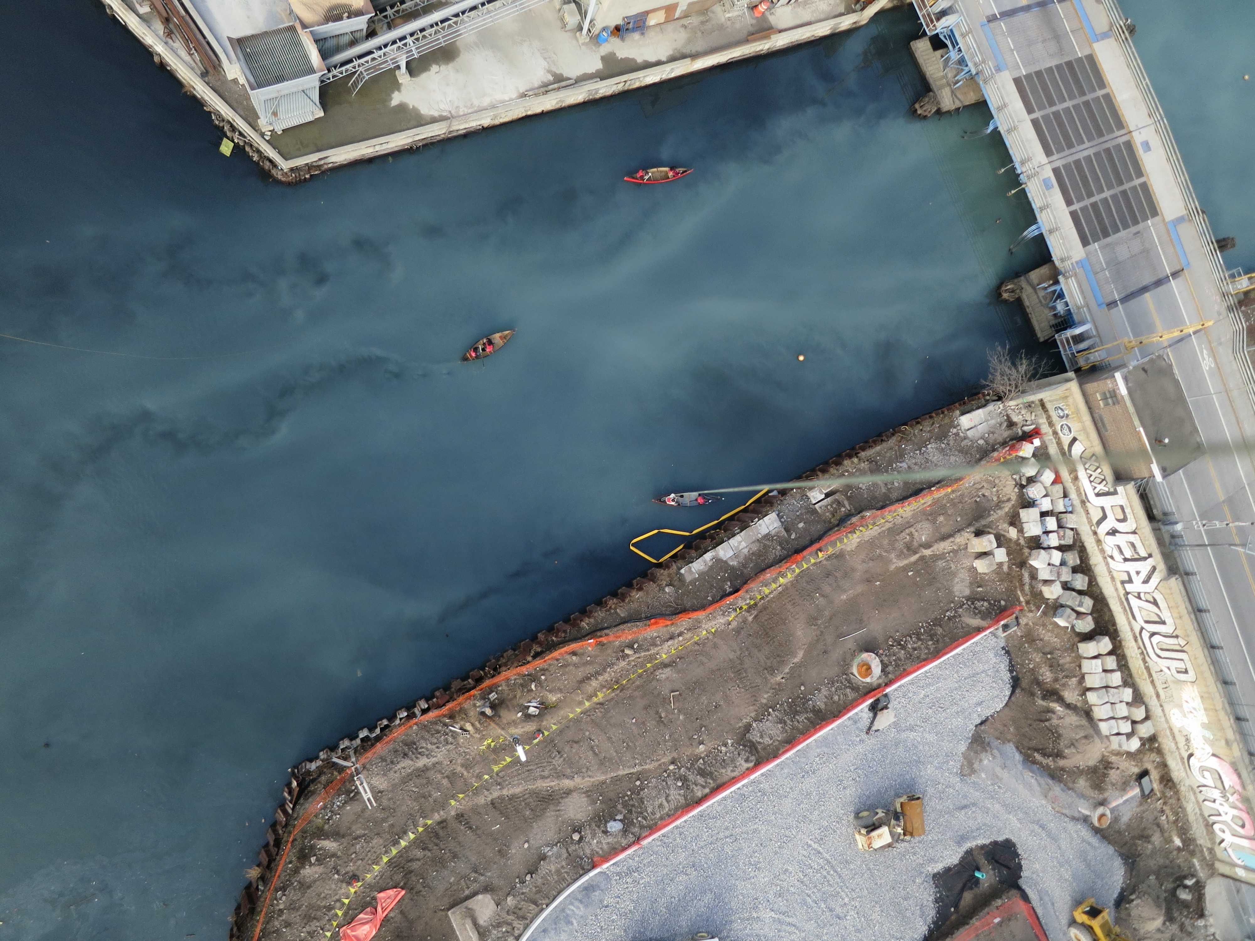
The Gowanus Canal Conservancy is conducting environmental investigations in the Gowanus Canal sub-watershed by using balloons and kites to capture aerial imagery. The Gowanus Low-Altitude Mapping (GLAM) project aims to document the changing urban landscape of the watershed. With this information, we hope to identify more areas to expand green space, in addition to position ourselves as a community watchdog during the Superfund cleanup. We have completed a four-part set of seasonal imagery from 2011, which is hosted in our archive. Sometimes we use a stereo camera rig to collect infrared imagery in addition to visible imagery. The data documents patterns/concentrations of vegetation or possible contaminants, monitors the stormwater retention design interventions that the GCC is installing along the canal edge, and reveals unknown or unidentified pipes or sources of groundwater entering the canal. In the long-term, this inquiry effort seeks to address the 300M gallons of untreated sewage that will continue entering the canal yearly even after the EPA finishes their Superfund clean-up of the toxic sediments at the bottom of the canal. See our Flickr gallery for our collection of aerial imagery.
Key GLAM researchers: Eymund Diegel, [Hans Hesselein], Natasia Sidhartha, Gena Wirth, Leif Percifield, and many more.
The Gowanus imagery has been republished by Google in Google Earth, and the salt lot map is now the default layer in Google Maps -- with attribution to "Public Laboratory": http://goo.gl/maps/LB9xI
The Gowanus Canal also hosts many technical development innovations. Thermal imaging is a newly developed approach to identify where warmer ground water is entering the cool waters of the canal. A thermal fishing bob can be towed through the water by a canoe. The temperature is displayed on a RGB LED. Data is collected by a timelapse camera set up on shore. Imagined and prototyped by Eymund Diegel, now Kaya Simmons is continuing the research in Boston and NYC. Follow along at http://publiclab.org/tag/thermal-photography.
The Water Hackathon in 2012 engaged Leif Percifield and team to create a water quality sensor for deployment in the Gowanus Canal. Follow along with developments in water quality sensors here: http://publiclab.org/tag/water-quality-sensor.
There are speculations by Jeff Laut and Eymund that dye tracing and underwater photography can help reveal where street drains empty into the Gowanus through previously un-noticed pipes. Follow along at http://publiclab.org/tag/dye-tracing
Cypress Hills
This 8 week Air Quality Class was created for the Cypress Hills Air Quality (CHAQ) Initiative, with support from the United States Environmental Protection Agency's program "Citizen Science: Community Involvement Today and in the Future". This project is in collaboration with the Cypress Hills Local Development Corporation. Program participants will spend 24 weeks working with air quality sensors to monitor indoor air pollutants in Cypress Hills and East New York. The students will catalog and analyze the environmental air pollutant hazards that affect neighborhood homes and will share their findings with other community members.
Joe Saavedra, Leif Percifield, and Liz Barry are the Public Lab facilitators. Georgia Bullen is involved through MIT, another partner on the grant.
Follow along at http://publiclab.org/tag/CHAQ

Jamaica Bay, Gateway National Park
Gena Wirth is leading a long-term investigation into the wetlands reconstruction effort by the Army Corps of Engineers in Jamaica Bay, New York. See her beautiful high-resolution maps and follow the project at http://publiclab.org/tag/jamaica-bay

Five Borough Farm
Liz Barry and Phil Silva are Outreach Fellows on Five Borough Farm, a project of the Design Trust for Public Space. Five Borough Farm provides a set of user-friendly tools that can be used by farmers and gardeners everywhere to track and evaluate urban agriculture's myriad impacts. The outcomes monitoring toolkit we developed is being piloted by 25+ community gardens and urban farms around New York City. Many of the sites are also being mapped through pole aerial photography in visible and infrared wavelengths -- follow our process at http://publiclab.org/tag/5BF

Lower East Side
Veronica Acosta has mapped Pier 42 with the Hester Street Collaborative and the local community as part of envisioning what the pier can become in the future.

Wendy Brawer of Green Maps joined the Lower East Side Ecology Center's group bicycle ride along the high water line of hurricane Sandy in June 2013. They used an Infragram to document how street trees were failing to leaf out. Their hypothesis was that due their small treebeds in the concrete sidewalks being full of salt and contaminants, street trees were suffering more than park trees:

Freshkills Park, Staten Island
Nick Johnson is investigating Freshkills Park, formerly Freshkills Landfill, as a part of an ongoing project titled Life of Trash, a project dedicated towards better understanding the invisible urban waste infrastructure and supporting community education and awareness around landfill activity. www.lifeoftrash.com
For over fifty years, trash from New York City was sent to Staten Island by barge to reach its final resting place, Freshkills Landfill. During its time, FreshKills Landfill was the largest landfill in the world, three times the size of Central Park, greater in volume than the Great Wall of China and visible from space. In 2001, the landfill was officially closed and efforts to turn this landfill into a public began. The process of landfill to park conversion began with capping the landfill's five mounds, a technical process which covers the waste with layers of clay, dirt and a synthetic membrane to prevent any waste from emerging from the landfill. The landfill conversion will be a thirty year project though sections of the park will become available earlier.
Freshkills Park is now focused on creating one of the most exciting parks in New York City. The vast landscape allows people to hike, canoe, ride bikes and birdwatch. Because of the park's peculiar nature, a great interest has arise around citizen science and how citizens can actively participate in understanding the environmental status of the park. This curiosity has initially begun with aerial photography which has not only yielded amazing aerial photographs and a unique map of the park, but has also provide the opportunity for citizens to explore the park first-hand and see what the area is really like. Each of these visits to the park is done in partnership with the New York City Parks Department which has an amazing and knowledgeable staff, excited and willing to share all of Freshkills Park's amazing story.
Christina Meilene has been participating in this project as well. View images of the last expedition

NY Harbor and the Hudson River
Several partnering organizations are testing out research methods for a variety of topics and sites in NY Harbor and along the Hudson River including mapping oyster reefs by NY/NJ Baykeeper and mapping phragmites by Nature Conservancy of NY. See oyster reefs (and discarded tires) visible at lunar low tide in the Bronx River:

Newtown Creek
Just starting up is a Newtown Creek monitoring project, where the first set of imagery was collected from the Riverkeeper boat during a shoreline infrastructure assessment in summer 2011. (In progress map). Newtown Creek is another EPA Superfund site within the five boroughs of NYC.

(Above: A plume of unidentified material in Newtown Creek, photographed with a balloon mapping kit by PLOTS mappers and Riverkeeper in 2011)
Aurash Khawarzad led a kite mapping party on site in summer 2012.
New Jersey
Sean McGuinness is New Jersey's main Public Lab organizer. He also works closely with the newly formed (2013) Philadelphia group.
An early regional project was Grassroots Newark, organized by Jen Hudon in 2011, which focused on development and community issues on both sides of the Passaic River:
http://grassrootsnewark.wordpress.com/.
Event mapping
Oscar Brett has led events to crowd-assemble party balloons into rigs with upwards of 100 people to map Occupy Wall Street marches: see http://publiclab.org/notes/oscar-brett/5-22-2012/may-day-community-aerial, events and maps.

History: our beginnings in 2010
NYC supported the Gulf Coast response to the BP Oil Spill in May 2010. Current and past students of Liz Barry met up outside of class to help the Grassroots Mappers with remote logistics such as connecting volunteer mappers with available spots on boats at specific marinas from which the most vulnerable wetlands could be reached. This group included Molly Oberholtzer, Ian Pugh, and Kaushal Shrestha, and Corey Mullee, and went on to create their own balloon aerial mapping rig with CHDK camera.
The first ever Grassroots Mapping workshop was held in New York City in June 2010 in the collab space and at the Hudson River Piers. Natalie Jeremijenko, Victoria Marshall, Liz Barry, Jeff Warren and about 6 others attended.
An October 2010 workshop was held at Union Square with Parsons The New School for Design, see the blog post on GrassrootsMapping.org. Victoria Marshall was instumental in making this workshop happen. Jen Hudon, Lee Altman, Jenny Chou (who went on to lead aerial mapping in Beijing), and Leif Percifield joined at this time. The New School Geo Club was a briefly lived student group that was active mapping social patterns in Washington Square Park and other sites.