New York City
Welcome! A great overview on New York City issues and local agendas is presented in NYC's Environmental Justice Alliance's Climate Justice Agenda: http://nyc-eja.org/public/publications/NYC_ClimateJusticeAgenda.pdf
Local organizers
- Eymund Diegel
- Laura Chipley
- Bronwen Densmore
- Sean McGinnis
- Natasia Sidarta
- Nick Johnson
- Oscar Brett
- Gena Wirth
- Lela Prashad
- Liz Barry: also on staff
Lending Library
We have a lending library of tools, instructional materials, and a Makerbot in Brooklyn, NY. Inquire about borrowing equipment, attending events, launching a new research project and more on the PLOTS-NYC mailing list.
The Public Lab NYC community's mapping efforts are featured in Google Maps. (Below: a plume discovered with near-infrared balloon photography in the Gowanus Canal in 2011 by PLOTS mappers and the GCC)

Gowanus Low Altitude Mapping (GLAM), Brooklyn
Public Lab northeast's longest running research site has involved hundreds of people in community science and generated data that has influenced the EPA's Superfund Cleanup process.
Read the whole story here: http://publiclab.org/wiki/glam
Follow along to get updates: http://publiclab.org/tag/gowanus
Geo NYC May Meetup: Eymund Diegel, Gowanus Canal Conservancy's Grassroots Mapping from OpenGeo on Vimeo.
2014 update: the project has grown to encompass upland portions of the watershed, read more about how springs from Prospect Park contribute flowing groundwater into the Gowanus: http://publiclab.org/tag/prospect-park
Jamaica Bay, Gateway National Park
Gena Wirth is leading a long-term investigation into the wetlands reconstruction efforts by the Army Corps of Engineers and the American Littoral Society in Jamaica Bay, New York. See her beautiful high-resolution maps and follow the project at http://publiclab.org/tag/jamaica-bay

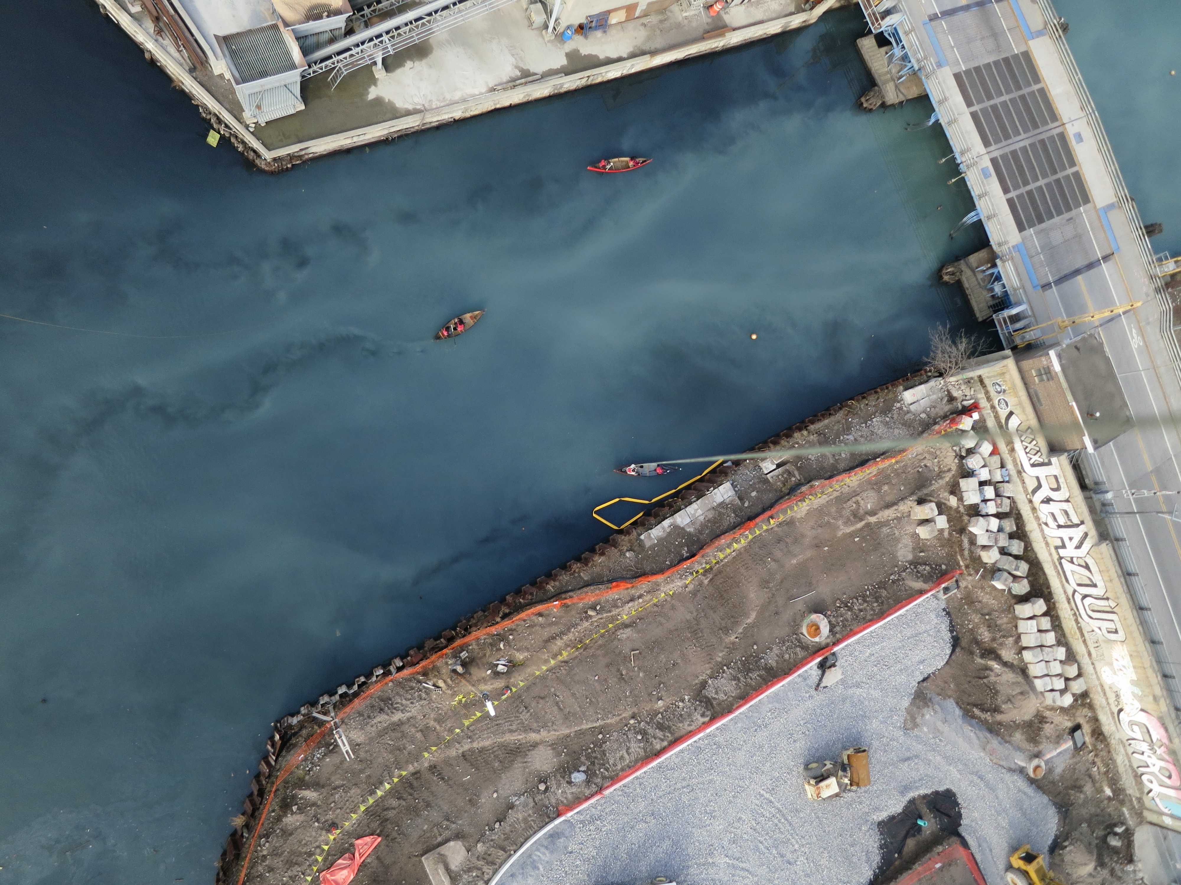
Newtown Creek
Project page: http://publiclab.org/wiki/newtown-creek
Follow along to get updates on Newtown Creek research, subscribe here: http://publiclab.org/tag/newtown-creek
The Newtown Creek monitoring project is just getting underway with partners North Brooklyn Boat Club and Newtown Creek Alliance. We are planning aerial mapping support for the impending release of EPA's Phase 1 assessment of the "State of the Creek" via canoes! We are also interested in oil testing, primarily sheens on water.

Above: the launch site for the December 7, 2013 Public Mapping Mission with NBBC, NCA, CUSP, and GovLab. Research Note here
Flushing Bay, Queens
Project page: http://publiclab.org/wiki/flushing-bay
Follow this research site at http://publiclab.org/tag/flushing-bay
The women of Empire Dragon Boat launch their boats right next to a large pipe that dumps out 5% of NYC's total sewage overflows. They are interested in building up a community advocacy campaign that features aerial imagery and water quality data. The timing is good for this community investigation, as DEP is hosting public hearings to develop a stormwater plan for this area.

Staten Island's north shore
Project page: http://publiclab.org/wiki/staten-island
Concern about floodwater carrying pollution from former industrial and radioactive sites into adjacent neighborhoods has resulted in the Northshore Waterfront Conservancy and the City University of New York being awarded a 2014 Environmental Justice grant from NY State Dept Environmental Conservation. The project is to identify:
- which sites are actually contaminated,
- which sites are vulnerable to flooding,
- where contaminated floodwaters will / should flow after leaving those sites,
- what flood-resistant infrastructure has already been built, and
- what flood-resistant infrastructure is needed.
Williamsburg's southside

Project page: http://publiclab.org/wiki/williamsburg
Follow along at http://publiclab.org/tag/southside
el Puente in South Williamsburg has experimented with balloon mapping to document greening and community redevelopment sites.
Newark, New Jersey

http://publiclab.org/wiki/newark Follow along at http://publiclab.org/tag/newark
Public Lab is working with amazing EJ activists at Green Community Garden, one of the City of Newark's Adopt A Lot participants, in Newark, NJ on infrared imagery and garden metrics. Supported by a small grant from the Environmental Leadership Program, this collaboration will result in an urban ag toolkit.
Bronx River at Soundview Park

Several partnering organizations are testing out research methods for a variety of topics and sites in NY Harbor and along the Hudson River including mapping oyster reefs by NY/NJ Baykeeper and mapping phragmites by Nature Conservancy of NY. See oyster reefs (and discarded tires) visible at lunar low tide in the Bronx River. (2013)
Freshkills Park, Staten Island

Read all about the project here: http://publiclab.org/wiki/freshkills-park Follow along: http://publiclab.org/tag/fresh-kills
Organizer Nick Johnson is investigating Freshkills Park, formerly Freshkills Landfill, as a part of an ongoing project titled Life of Trash, a project dedicated towards better understanding the invisible urban waste infrastructure and supporting community education and awareness around landfill activity. Open Trash Lab: Freshkills. This project is in partnership with the Staten Island Department of Parks.
Five Borough Farm
Project page: http://publiclab.org/wiki/5bf
Philip Silva and Liz Barry are Outreach Fellows on Five Borough Farm, a project of the Design Trust for Public Space. Five Borough Farm provides a set of user-friendly tools that can be used by farmers and gardeners everywhere to track and evaluate urban agriculture's myriad impacts. Many of the sites are also being mapped through pole aerial photography in visible and infrared wavelengths -- follow our process at http://publiclab.org/tag/5BF

Cypress Hills
This 8 week Air Quality Class was created for the Cypress Hills Air Quality (CHAQ) Initiative, with support from the United States Environmental Protection Agency's program "Citizen Science: Community Involvement Today and in the Future". This project is in collaboration with the Cypress Hills Local Development Corporation. Program participants will spend 24 weeks working with air quality sensors to monitor indoor air pollutants in Cypress Hills and East New York. The students will catalog and analyze the environmental air pollutant hazards that affect neighborhood homes and will share their findings with other community members. Follow along at http://publiclab.org/tag/CHAQ

Inwood and upper Manhattan
Jen Hudon and colleagues:

Lower East Side
Veronica Acosta has mapped Pier 42 with the Hester Street Collaborative and the local community as part of envisioning what the pier can become in the future.

Wendy Brawer of Green Maps joined the Lower East Side Ecology Center's group bicycle ride along the high water line of hurricane Sandy in June 2013. They used an Infragram to document how street trees were failing to leaf out. Their hypothesis was that due their small treebeds in the concrete sidewalks being full of salt and contaminants, street trees were suffering more than park trees:

Washington Square Park
Washington Square Park is a perennial favorite "first time mapping" spot. Many many expeditions have happened here! Check out this gif by (Colin McFayden](http://colinmacfadyen.info/)

Event mapping
Oscar Brett has led events to crowd-assemble party balloons into rigs with upwards of 100 people to map Occupy Wall Street marches: see http://publiclab.org/notes/oscar-brett/5-22-2012/may-day-community-aerial, events and maps.

List of all regional maps created
[updated July 31, 2013] These nine maps have been added to the Google satellite base layer. Also listed, two NDVI/IR maps taken to accompany visible imagery on same date.
http://publiclab.org/map/cannoneer-lot-green-infrastructure-project-brooklyn-new-york/2012-10-25
http://publiclab.org/map/washington-square-park-new-york-new-york/2012-10-01
http://publiclab.org/map/soundview-oyster-reef-orrp-nyc-bronx-new-york/2012-08-21
http://publiclab.org/map/newtown-creek-north-brooklyn-ny/2011-08-06
http://publiclab.org/map/newtown-creek-brooklyn-ny/2011-08-06
http://publiclab.org/map/washington-square-park-new-york-city/2011-04-27
http://publiclab.org/map/gowanus-canal-brooklyn-new-york/2011-03-27
http://publiclab.org/map/gowanus-canal-brooklyn-new-york/2011-01-22 http://publiclab.org/map/gowanus-brooklyn-ny/2011-07-31
http://publiclab.org/map/passaic-riverfront-newark-new-jersey/2010-11-23 Passaic River
http://publiclab.org/map/macurisa-conference-balloon-flight-atlantic-city-new-jersey/2012-10-23 Atlantic City
These two NDVI and IR maps listed below are not in Google because they are the exact same date as the visible light map and Google can only take one map for any given date/location:
History: our beginnings in 2010
NYC supported the Gulf Coast response to the BP Oil Spill in May 2010. Current and past students of Liz Barry met up outside of class to help the Grassroots Mappers with remote logistics such as connecting volunteer mappers with available spots on boats at specific marinas from which the most vulnerable wetlands could be reached. This group included Molly Oberholtzer, Ian Pugh, and Kaushal Shrestha, and Corey Mullee, and went on to create their own balloon aerial mapping rig with CHDK camera.
The first ever Grassroots Mapping workshop was held in New York City in June 2010 in the collab space and at the Hudson River Piers. Natalie Jeremijenko, Victoria Marshall, Liz Barry, Jeff Warren and about 6 others attended.
An October 2010 workshop was held at Union Square with Parsons The New School for Design, see the blog post on GrassrootsMapping.org. Victoria Marshall was instumental in making this workshop happen. Jen Hudon, Lee Altman, Jenny Chou (who went on to lead aerial mapping in Beijing), and Leif Percifield joined at this time. The New School Geo Club was a briefly lived student group that was active mapping social patterns in Washington Square Park and other sites.