Mapping the Waste Stream of Southern California
About the issue and the project
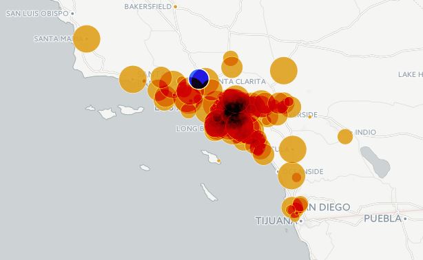
One of the main issues with waste is that it needs to be transported. Local landfills have long since been replaced by large, regional landfills where waste from more metropolitan areas is gathered and then sent to be landfilled or recycled at a faraway location. When a garbage truck picks up your weekly curbside waste, that waste will likely make its way to a landfill or recycling facility only after it has traveled many miles on interstate and highways, passing through several transfer stations, and then more roads. In some cases, your trash will cross multiple county lines, or perhaps a state line, before it is finally recycled or landfilled.
Using the region of Southern California as a case study, we would like to investigate the real environmental impact of transporting waste in the era of mega-landfills. Do waste-by-rail projects, such as Los Angeles' Mesquite Regional Landfill, result in lower greenhouse gas emissions and do they offer a less deleterious solution as we make our way toward a zero-waste society?
The process of sending waste to transfer stations and to other municipalities also has the effect of obscuring the waste picture for a town or city. This effect can be quite serious, since not knowing how much waste your town produces or knowing where it goes may result in difficulties when advocating for and implementing responsible waste policies. In practice, it can also present problems when researchers, agencies and individuals and interpret and respond to environmental impact reports, such as planning documents required for the California Environmental Quality Act, (CEQA).
This project mainly seeks to democratize data and data-visualization tools by documenting our process of waste-data analysis.
People who are involved
Project Lead: Sara Sage
Participants: If you are interested in being involved with this project, please comment below, contact the Project Lead, write a research note, join the LA Google Group and drop a note, or directly contribute to this wiki.
Groups: Students at Learn Beyond the Book in Santa Clarita, California, including instructor, Elizabeth Rydall, who teaches the class, "Art & Science of Recycling, Repurposing & Re-using"
Join us to chat here on the LA Google Group
Next steps and what are we working on now:
- Uploading and ongoing analysis of CalEPA/CalRecycle waste-origin data
- Inventory of waste disposal sites and transfer stations throughout Southern California
- Develop a unit lesson plan for educators who ware interested in investigating their local waste stream with students -- with hands-on educational activities and options by grade level
- Investigating the potential of GPS-tracking technology to analyze (near) real-time movement of waste in Southern California.
- Developing outreach and partnerships with organizations that promote understanding of waste and zero-waste policies
Updates
Subscribe to updates on this project
| Title | Author | Updated | Likes | Comments |
|---|---|---|---|---|
| Solid Waste Facilities in California | @herk | over 7 years ago | 2 | 3 |
| SoCal Waste Stream Mapping at Learn Beyond the Book in Santa Clarita | @sarasage | over 8 years ago | 3 | 0 |
| Regional Barnraising 2016: A Few Thoughts About Public Lab's Work | @sarasage | over 8 years ago | 5 | 2 |
Activities we’ve done in our project
| Purpose | Category | Status | Author | Time | Difficulty | Replications |
|---|---|---|---|---|---|---|
| Community-level Odor Mapping Site | - | - | @sarasage | - | - | 0 replications: Try it » |
Activities should include a materials list, costs and a step-by-step guide to construction with photos. Learn what makes a good activity here.
Data
List of Waste Facilities by County This list is a work-in-progress hosted on Google Sheets. Please contact the Project Lead for permission to edit this document.
Questions
- What is the definition of Southern California?
- Where do waste regions end and begin? How defined are they?
- What is the burden of industrial waste compared to consumer waste?
- What type of awareness/advocacy tools can we develop as a result of this project? (i.e. infographics, spreadsheets, long-form articles, animation).
- How do privately-run landfills compare to landfills run by government agencies?
| Title | Author | Updated | Likes | Comments |
|---|---|---|---|---|
| How does bio-waste move within the waste stream? | @sarasage | over 8 years ago | 1 | 0 |
Resources
Important Links for Obtaining Waste Data
CalRecycle Facility Search Entering the name of a landfill or waste-sorting facility in the field, SWIS site name, will bring up information for that particular facility. Please explore the tabs marked, inspection, enforcement, maps & documents.
Inflow-Outflow Map Generator at CalRecycle The State of California has its own map generator to track reported inflow and outflow for landfills, as well as for a jurisdiction. With this awesome tool, you can see where your own city sends waste, as well as see which jurisdictions send waste to a particular landfill.
We’re looking for:
- People with expertise in calculating and modeling GHG emissions of waste-industry traffic
- Individuals with Carto (CartoDB) skills to assist with data visualization
- Individuals who are interested in participating in a GPS-tracking project, introduce GPS devices into the waste stream
- Artists with film/animation skills, graphic design skills, as well as pen-and-paper skills
- Educators with experience writing lesson plans
- Individuals who are interested in gathering, sorting and analyzing state and local data
- Your ideas and feedback!
__ Our project tag: SoCalWasteStream
Others we follow: