Public Lab
Research note

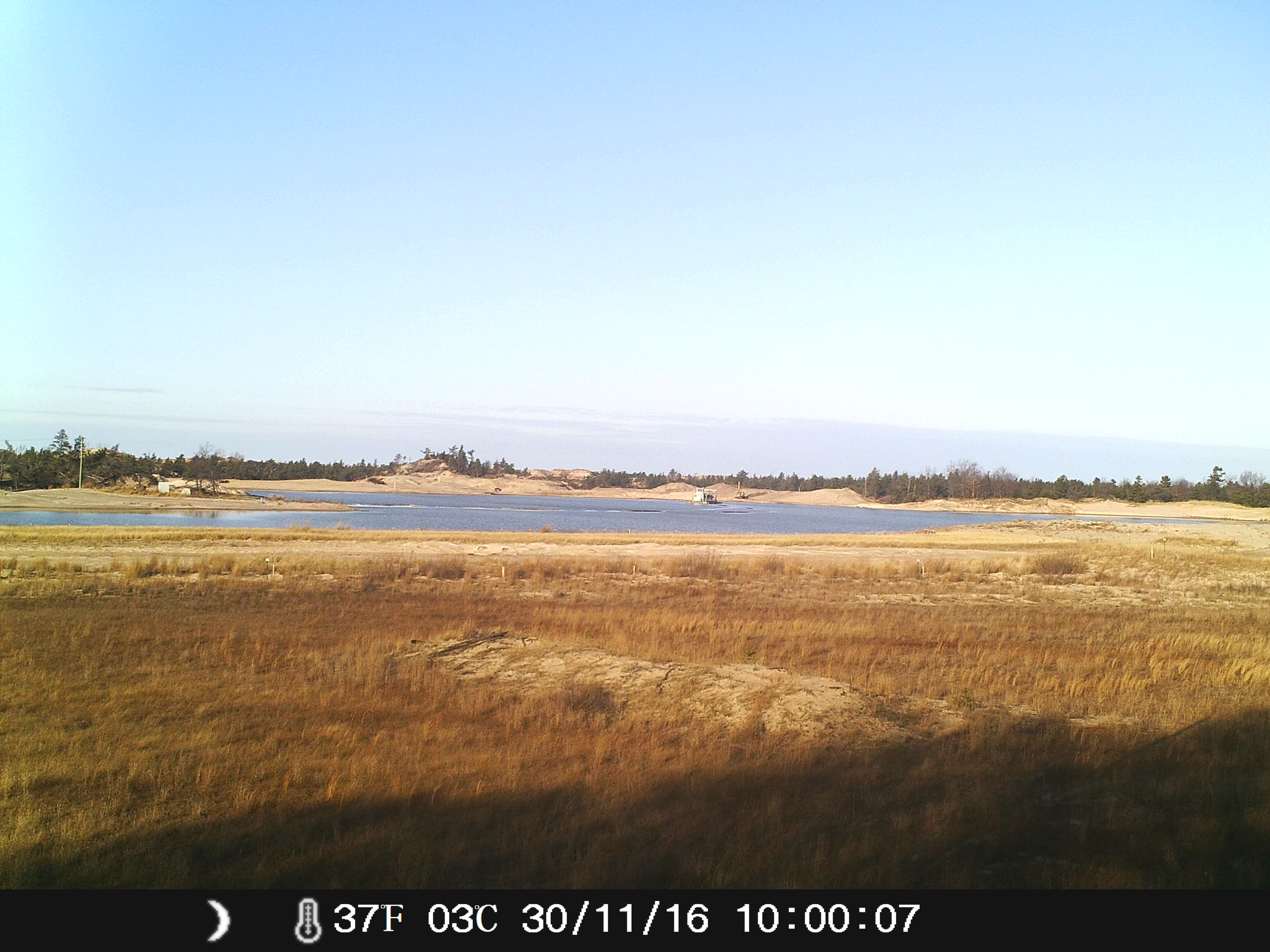
Monitoring Sargent Sand Mining operation in Ludington, Michigan
What I want to do: We are simply monitoring/watching for any egregious destruction ( outside of permit-allowed removal) of sand dunes at the Sargent Sand Co. Ludington, MI site.
My attempt and results: We have positioned a trail-cam approx. 200 yards from a vertical mining lake that is being created by dredging equipment
Questions and next steps: After reviewing images taken so far (twice daily at 10:00 am and 4:00 pm), I am considering moving the trail-cam closer to obtain better images. My worry, however, is the discovery or the theft of the trail cam.
Why I'm interested: We want to ensure that there will be a chronological record of the degree to which the dune landscape is being changed
24 Comments
Oh, this is great to see. I know that in this note, @cfastie made a video from his timelapse using the same Crenova trail camera. Chris, how did you do that? Was it a pretty easy conversion?
@DMerwitz @marlokeno @stevie @bkleist - encouraging to see this working out here -- take a look!
Is this a question? Click here to post it to the Questions page.
Reply to this comment...
Log in to comment
Video editing programs usually have some way of converting photos into the frames of a video.
In Adobe Premiere Elements if you click Add_Media/Files_and_Folders, the next dialog has an obscure check box called "Numbered Stills." If you check that and click on just the first photo in a directory, Premiere will make a video using all the photos as individual frames. This only works if the filenames of the photos have numbers in them and the numbers are consecutive (none can be missing). You can also have each photo repeated as two or more frames in the video, but that might work only in Premiere Pro, not Premiere Elements, and that variable must be set in the program preferences (Edit/Preferences).
Yes, Adobe programs really are that terrible.
Chris
Reply to this comment...
Log in to comment
Thanks, Chris - i figured it's a good idea to compile a bunch of options, so I posted a question and added your response as an answer, along with a link to some good-looking YouTube videos on how to do it in a few other programs. But I haven't done it myself!
Reply to this comment...
Log in to comment
Oops, link: https://publiclab.org/questions/warren/12-05-2016/how-do-i-make-a-video-from-a-series-of-photos
Reply to this comment...
Log in to comment
Hi Glenn! You can also use an unexpensive tool combined with your amazing monitoring on the ground that is using the Google Earth "map over time" feature Here are the steps to do it https://support.google.com/earth/answer/148094?hl=en
In the case you are a GNU/Linux user you can give a try to Kdenlive timelapse feature. Here a 3 minute video explaining how to do it ;) https://www.youtube.com/watch?v=VVqrxNV5Y_s
Is this a question? Click here to post it to the Questions page.
Reply to this comment...
Log in to comment
On mac, the easiest way is to use Quicktime 7, File --> Open Image Sequence
Is this a question? Click here to post it to the Questions page.
Reply to this comment...
Log in to comment
@xrose, https://www.mapillary.com/ is also an open source, OpenStreetMap based system for doing the same thing-- placing images on a map, with timelapse export options for historical data and and "streetview" style walkthroughs for geographically placed photos.
Reply to this comment...
Log in to comment
Wooow @mathew thanks a lot! It looks great! I understand this is a crowdsourced app to collectively create a map isn't it? (I'm downloading right now ;) I refer to the GoogleEarth feature not to upload the images but to check the existing ones in "sauron's database" as they constantly update geographic-satellite images. Download complete... ;)
Is this a question? Click here to post it to the Questions page.
Reply to this comment...
Log in to comment
Yes, OpenStreetMap is an open project to crowdsource a map (they have a lot of institutional partners too, like my fair city, Portland, OR). Mapillary is another layer to crowdsource streetview. It doesn't have to be on a street, however, and could be used to place images around a facility.
They have a few tutorials on using imagery that wasn't captured by their phone app too: http://blog.mapillary.com/news/2015/01/08/video-cutting.html http://blog.mapillary.com/update/2016/04/28/multiple-garmin-ios.html
Reply to this comment...
Log in to comment
Thank-you, xose! I will look into how I might be able to accomplish that over the next couple of days!
Reply to this comment...
Log in to comment
Just to put this out there, for folks who do have all the software set up and such, perhaps as more folks make timelapses, we could be mailing the SD cards around to those who can make videos. (probably making backup copies first, of course!)
Reply to this comment...
Log in to comment
Hey Glenn! Shooting word over from the Traverse City area. I'd love to collaborate and do some spatial/statistical analysis and get some quantitative results on Sargent's operation in Ludington. I'm guessing I'd use GIS as well as OpenStreetMap/Google Earth input.
I'd be doing this as work for an independent study that I'm taking, so bear in mind that I'm currently studying & learning the methodology and such that's involved. Let me know your thoughts! Hope all's coming along well.
Reply to this comment...
Log in to comment
That's great to hear, @tayreed.
I'm also asking around where I live to see if some folks are interested in putting together a guide on setting up these trail cameras, to try to get a lot more people doing so. I know some folks have had trouble with getting them into timelapse mode, so maybe we can make a video of that sequence to help.
Reply to this comment...
Log in to comment
Warren,
What a putz I am. When I set up our Trailcam, I just kinda followed the the set-up feature intuitively because I lost the manual (actually, it was discarded as unwanted trash by my wife). Therefore, I'd be almost NO help to you in programming a time-lapse mode feature, if one exists on our camera. I programmed it to simply take TWO PHOTOS per day...one at 10:00 am and one at 4:00 pm. It has the capability (obviously) to take pics hourly, but Sargent Sand's dredge mining has ceased since their "lake" froze in mid-December and they're doing no active surface mining these days...they are simply moving and removing/loading to trucks their Fall stockpiles. ( I've moved it to a different location for that reason...no sense in taking pics of a frozen lake, I guess!)
I'll attempt to attach a photo or two of how we set up our Cam as inconspicuously as was deemed possible (and productive enough) along the perimeter of their property line. It isn't "pretty", but it works.
Reply to this comment...
Log in to comment
@tayreed that sounds interesting! Would love to hear more.
@glennwalquist - great setup photos! Did you use the wooden block to camouflage it with the grass? Looks good!
Is this a question? Click here to post it to the Questions page.
Reply to this comment...
Log in to comment
Super photos, thank you! Have you retrieved images yet? I wonder how long it'll last at a lower capture rate, hopefully the battery will last longer that way. The box says it can go for a month or more!
Is this a question? Click here to post it to the Questions page.
Reply to this comment...
Log in to comment
I haven't had to change batteries (yet) since we set it up near the end of October...I do believe that the twice daily pic set-up is the main reason for the long battery life ( I recall the instructions noting that). It is producing what I consider to be very good quality shots( though there have been a couple of "misfires"-like the one in the middle- for whatever reason)...I'll attach a couple of THOSE shots here now. I'm convinced that this will be sufficient to gauge grossly obvious egregious or impermissible mining activity, should there ever be any.
Reply to this comment...
Log in to comment
@stevie
Yes, I guess I just kind of assumed that a 2x4 piece of treated wood would be less likely to stand out ( I wrote a fictional name on the post,too...."property of.... with MY own cell phone # on it to give it the appearance of a simple deer hunter's trail-cam in the event that it was discovered, also thinking that this would deter theft). The green fence post's flat face made it easy to attach the trail-cam using the zip-ties AFTER driving the post into the ground. It "works"!
Reply to this comment...
Log in to comment
That's so smart!
Reply to this comment...
Log in to comment
Hi, in case it's helpful, here are the instructions!
Reply to this comment...
Log in to comment
@warren Thanks for the copies of the trail cam instructions!
Reply to this comment...
Log in to comment
@glennwalquist
Hey Glenn,
Ah, I'm struggling to come up with options for analysis of Sargent's operations. The only thing I can think of is landscape metric type analysis based on satellite imagery over time, and I just don't think that information would be relevant for much of anything...
I'll keep turning it over in my head. Let me know if you, or anyone else, have any thoughts.
Be well, and keep the pictures coming-
Reply to this comment...
Log in to comment
@tayreed Thank-you for getting back to me regarding this subject and your thoughts on it. I think that any data that approximates the quantity of sand ( in tonnage or some other practical measure ) that is being removed above and beneath the surface of the mining site is really what groups like ourselves (and FracTracker Alliance) are striving to somehow obtain. Apparently NOBODY knows this information or it's nearly impossible to get...Privately held companies must feel that it is too sensitive of a subject to allow access to. If you can think of anything, it would be appreciated. And like I said, I'd be happy to help in any way that I am capable. Thanks again!
Reply to this comment...
Log in to comment
Hi @glennwalquist -- I'm curious if volume of sand could be measured using a 3d app like this:
http://www.123dapp.com/catch
Perhaps using some of the methods here:
https://publiclab.org/notes/patcoyle/03-27-2014/example-using-free-sfm-tools-for-calculation-of-volume-of-earth-mound-on-construction-site
https://publiclab.org/notes/cfastie/10-23-2016/3d-visualizations-from-aerial-photos-of-a-landfill-video
I just posted a question on this and hopefully Chris and Pat will have some thoughts:
https://publiclab.org/questions/warren/02-28-2017/calculating-volume-from-ground-level-photos
Reply to this comment...
Log in to comment
Login to comment.