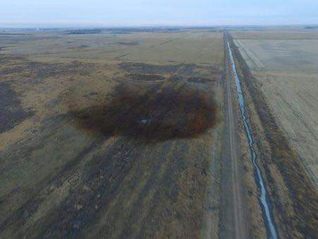
I'm looking to get water protectors involved in using the potentiostat and spectrometer to make a map of the Keystone leak by posting data to Twitter, flooding Trump's account, and mapping it.
"WikiArsenic Step 1: Posting GPS Coordinates from Android Phone to Twitter with Thunkable in One..." @erbil_dr https://medium.com/@kayaerbil/wikiarsenic-step-1-posting-gps-coordinates-from-android-phone-to-twitter-with-thunkable-in-one-2437f35a2d6c
Hi, I was thinking that one thing that might really help to:
would be to build out some guidance on taking the samples -- the scanning, testing etc can then happen in a coordinated way a bit later. Would this be helpful to you?
There are the beginning of some resources up at https://publiclab.org/wiki/sampling -- would this be for soil or water samples?
One thing this could enable is simultaneous testing using an established lab method and a lower-cost method, which can help to prove out the lower-cost methods (or, as the case may be, show that they need work!).
Is this a question? Click here to post it to the Questions page.
Reply to this comment...
Log in to comment
If you're in touch with water protectors, maybe there is already some documentation we can help compile based on their workflow?
Thanks for posting!
Is this a question? Click here to post it to the Questions page.
Reply to this comment...
Log in to comment
Interesting question! if you'd like to elaborate a bit more on your thoughts or talk about how the photo spectroscopy kit could be of help, please consider dropping into the weekly open hour https://publiclab.org/wiki/open-call
Reply to this comment...
Log in to comment
I am in touch with someone who lives in Standing Rock who used to work for the EPA and left because of corruption. She's talking about getting a jet ski to do mapping of water around the reservation next spring. I am looking to try getting the potentiometer and the spectrometer working and would like to talk to people about metals. I am also looking at mapping uranium runoff in Pine Ridge around the power plant that Georgia Power is planning to build here in Georgia. I am thinking about connect with labs at Emory or the CDC that have worked with Flint and other metals contamination sites. I'll try to meet about the weekly call in hour to talk more to you about it.
Reply to this comment...
Log in to comment
https://geosciencealliance.wordpress.com/ I am going to reach out to the geoscience alliance about this. It's something my friend suggested. Also, Flathead reservation, Navajo reservation, and sitting bull college.
Reply to this comment...
Log in to comment