Some background:
Cherokee Concerned Citizens has been an active community group fighting the ongoing industrial pollution that affects their community since 2014 (read an earlier post on our community here). The neighborhood in Pascagoula Mississippi is surrounded by several facilities (the Bayou Casotte Industrial Park), including Chevron which has been active for over 50 years, VT Halter Marine, LNG, BP Enterprise Gas Processing, and First Chemical. After years of individual complaints to the Mississippi Department of Environmental Quality, residents came together in 2013 to address their common issues relating to the sickening industrial odors and toxic particulate matter that they believed explained their health issues, including rashes, respiratory issues, asthma, chronic colds and sinus problems, burning eyes, nose, and throats, tingling and numbness, sleep disorders, memory problems, digestive issues, cancers, and more.
Over the years, the group has been documenting pollutants such as benzene, sulfuric acid, sulfur, particulate matter, manganese, and particulate matter. They have documented sandblasting overspray, industrial noise pollution, managed their own odor logs, and conducted health surveys. For years they’ve monitored, reported, and documented, to no avail. They’ve been kept out of federal processes for contributing through an EPA Community Advisory Committee, had their data ignored by their state Department of Environmental Quality, and waited 6 years for expired permits to come up for renewal so they can register comments on them, but none, save one, have. In fact, one company, Mississippi Phosphates, responsible for creating a superfund site, operated under and expired permit for 10 years before they went bankrupt, burdening the community with “700 million gallons of acidic, nutrient-rich wastewater” costing the federal government more than $34 million dollars as of 2019.
An Update:
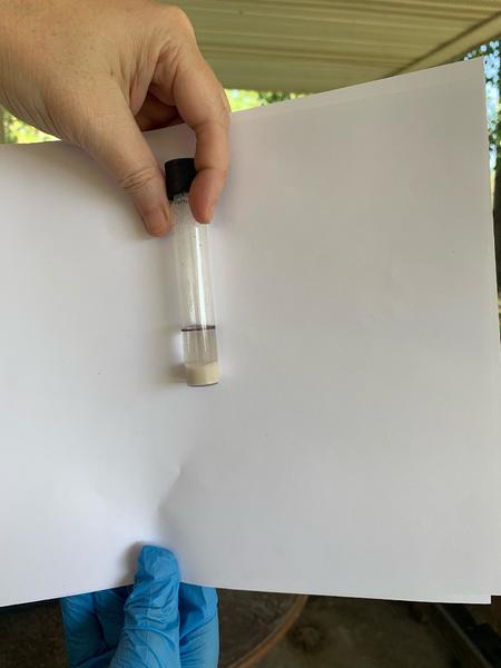
After being ignored for years by EPA and MDEQ, Cherokee Concerned Citizens (CCC) got in touch with the Agency for Toxics Substances and Disease Registry (ATSDR) who agreed to do an investigation into the existing data. However, ATSDR won’t do any testing themselves so CCC has been gathering some more data to share. In Spring 2020, CCC reached out to Public Lab to borrow a Hanby soil testing kit, and started testing. They took photos and tests, and working with a lab in Houston, were able to get some analysis and results. Of the tests conducted, Hanby said there’s a higher level of petroleum pollution in the samples than what you would want in a residential area, 5x the level of "healthy" soils for oil and gas related contamination. They said it’s concerning and CCC should get it tested with the EPA. ATSDR is going to take this data, along with all the other data and submit a report to the EPA with recommendations to the EPA on how they should handle the contamination.
 The photo is from soil testing in a neighborhood in Pascagoula, Mississippi. It shows 500ppm of oil related contamination.
How you can help us
Here are several questions we’re looking for insight on. Please click the links to help answer or pass along more information! Or comment on this post. Thanks so much!
- Chevron is up for a permit renewal again (under title 5 of the Clean Air Act), we have a 4800 page report on the company, how can we get through it and pull out the valuable info?
- What would be the petition process to the EPA? And what are the criteria for a strong petition?
- Is it illegal for the US EPA to deny the Community Advisory Group process because of a random, unnamed reporter claiming that the communities in the vicinity of the Superfund site are already engaged?
- For US Environmental Protection Agency Community Advisory Groups (CAGs): Does the EPA have to engage the local communities in the Superfund vicinity? And if so, what does that process need to look like?
- In terms of community science, MDEQ already discredited community based science, what might add legitimacy to our data?

3 Comments
@stevie has marked @cherokeeconcernedcitizens as a co-author.
Reply to this comment...
Log in to comment
@CherokeeConcernedCitizens Thanks for chatting with me the other day. Here are the general guides for soil testing that I mentioned. The notes in there about where to sample might be helpful for getting started with study design. More to come soon over the next couple months!
Soil testing guide from Statistics for Action: https://sfa.terc.edu/materials/pdfs/SfA_SoilGuide.pdf
Cornell Waste Management guide with strategies and general procedure for soil testing: http://cwmi.css.cornell.edu/guidetosoil.pdf
@CherokeeConcernedCitizens To help keep track of the samples you've already taken and see any patterns in the varied results you're getting, it might be helpful to create a map of your results? The map could also then be a visual tool to assist planning your next round of sampling.
Here are a couple activity posts on how to make these kinds of maps: + Host a collaborative map drawing workshop + Workshop guide: Mapping soil data
Is this a question? Click here to post it to the Questions page.
Reply to this comment...
Log in to comment
Login to comment.