[Photo Credit: Bridge the Gulf, from Article by Joe Womack "Africatown's Hog Bayou" 12/04/2014]
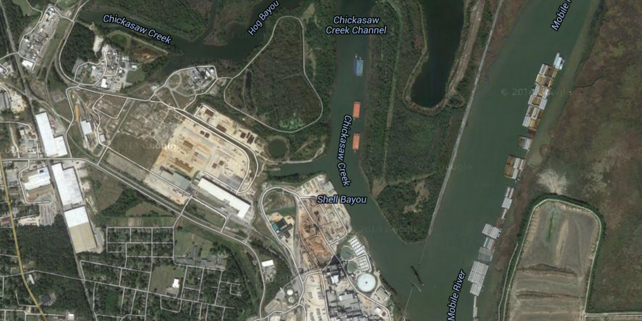
In preparation for the establishment of the Africatown Connections Blueway, a ten-mile water trail along Chickasaw Creek, that is being planned to connect historic Africatown, Alabama with the Africatown State Park in Prichard, Alabama, community residents have expressed an interest in identifying, monitoring and maintaining the sustainability of water quality for Chickasaw Creek and the adjacent Hog Bayou. The level of interest is particularly high given the community's long-term interest in safeguarding public health, environmental sustainability, recreational activities, local sustainable economic development and, ultimately, designating and promoting the Africatown Connections Blueway as a national or even international water trail destination for ecological-tourism and African-American cultural heritage tours.
The National Park Service (NPS) has been facilitating the planning and development of the Blueway Project, in collaboration with the Africatown and Prichard communities, the Mobile Area Environmental Justice Coalition (MEJAC), representatives of the Mayor's Office and City Council of Prichard, the Mobile County Training School Alumni Association, Groundwork - Mobile, the Alabama Coastal Foundation, Yorktown Church, Tuskegee University's Dept. of History and Political Science and their Remote Sensing & GIS faculty, Alliance Institute, Auburn University and the Public Laboratory for Open Technology & Science (Public Lab), among other stakeholders. The first of several Public Lab meetings focusing on the Blueway, supported by a grant from the National Academy of Sciences, was held at Prichard City Hall on August 29, 2017. A Public Lab Mapping Workshop for the Blueway will be held on Saturday, October 21, 2017 at the Robert L.Hope Community Center in Mobile, AL. A subsequent Workshop addressing water quality monitoring is being scheduled, all in preparation for the ribbon-cutting ceremony and associated celebratory events for the opening of the Blueway, scheduled for June 16 & 17, 2018, in conjunction with Juneteenth Day and Father's Day.
The mission statement developed by the community's planning committee for the Africatown Connections Blueway states:
"Our mission is to preserve the natural spaces, habitat, and waterways of historic Africatown in Mobile, AL, Africatown State Park in Prichard, AL and the 10 miles of Chickasaw Creek connecting the two, for the sustainability of healthy communities, educational enlightenment, and economic opportunities."
Some of the questions that have been asked by the community have included:
Will these water bodies continue to be safe for the following types of activities in future:
- kayaking and canoeing?
- swimming?
- fishing?
What affordable tools are available for the surrounding communities to test and monitor water quality?
Depending upon test results, what methods might be required for further water quality improvement?
What is the prior history of these waterways and shoreline activities that may have residual environmental impact, thereby requiring particular remediation, testing and monitoring?
What current riparian industrial facilities along these water bodies continue to require specific monitoring?
What riparian agricultural practices could be modified, so as to further protect the waterways from rainwater runoff (e.g. fertilizers and pesticides)?
Are there restoration and conservation initiatives (e.g. shoreline flora plantings, gravel placement) that could contribute to maintaining water quality?
How are these waterways protected by federal, state, county or municipal laws and regulations that could be better enforced or litigated?
Are these communities at risk for periodic flooding and, if so, can reasonable solutions be deployed?
Is there a need for and political potential for new legislation, regulatory policies or court judgements that could further protect these waterways, given Africatown's designation as National Historic Site, the waterways' protected status by the National Wildlife Federation and the Alabama Wildlife Federation, as well as the Blueway's potential as an attraction on the National African-American Freedom Trail and/or possible member of the Association of African-American Museums?
Your contributions to answering this questions, addressing these community concerns or posing new questions would be most welcomed.
BACKGROUND INFORMATION:
Africatown was founded by former residents of Ghana, who were taken to Alabama from the West coast of Africa illegally, aboard the slave ship Clotilde in 1860, notwithstanding the fact that in 1808, the United States government, under President Thomas Jefferson, had abolished the Atlantic slave trade. After manumission in 1863 by President Abraham Lincoln, they and their descendants built a community that continues to survive and is designated on the National Register of Historic Places.
Chickasaw Creek derives its name from the Chickasaw Nation. On August 31, 1830, "Representatives of the Chickasaw Nation signed the Treaty of Franklin with the United States, agreeing to cede their land in Alabama and Mississippi for an equal amount of land in the West. The treaty followed the passage of the Indian Removal Act earlier that year, but was soon voided due to the lack of suitable land. The two sides renegotiated in 1832 with the Treaty of Pontotoc Creek, in which the United States agreed to pay $3 million for Chickasaw land --- although payment stalled for 30 years. In 1837, most of Chickasaw Nation finally traveled to Oklahoma along the Trail of Tears, on which more than 500 died of dysentery and smallpox."
Mobile Bay National Estuary Program: A Division of the Dauphin Island Sea Lab. http://www.mobilebaynep.com/the_watersheds/eight_mile_creek_watershed/the_landscape
National Water Quality Monitoring Council Chickasaw Creek (NARS-OWW04440-0345) site data in the Water Quality Portal. https://www.waterqualitydata.us/provider/STORET/NARS/NARS-OWW04440-0345/
R.Peter Richards, Senior Research Scientist, National Center for Water Quality Research, Heidelberg University. "Analysis of Chickasaw Creek Concentrations and Loads: Summary of Major Findings, 2009-2011" USDA Natural Resources Conservation Service. https://www.nrcs.usda.gov/wps/portal/nrcs/detail/oh/technical/?cid=nrcs144p2_029524
Water Quality Standards for Clean Water Act Purposes. US EPA. Water Division, Alabama Department of Environmental Management (Rivers, Lakes, Creeks, etc. in Alabama)
https://www.epa.gov/sites/production/files/2014-12/documents/alwqs_chapter335611.pdf
Water Quality Samples for Alabama.
USGS 02471001 CHICKASAW CREEK NEAR KUSHLA AL. https://nwis.waterdata.usgs.gov/al/nwis/qwdata/?search_site_no=02471001&search_site_no_match_type=exact&sort_key=site_no&group_key=NONE&sitefile_output_format=html_table&column_name=agency_cd&column_name=site_no&column_name=station_nm&column_name=lat_va&column_name=long_va&column_name=state_cd&column_name=county_cd&column_name=alt_va&column_name=huc_cd&format=qw_sample_por_table&begin_date=&end_date=&inventory_output=0&rdb_inventory_output=file&date_format=YYYY-MM-DD&rdb_compression=file&qw_sample_wide=0&list_of_search_criteria=search_site_no
Chickasaw Creek. Mapcarta. (Map with commentary in Italian) https://mapcarta.com/it/20455688
In August of 1997, the Alabama Department of Environmental Management conducted a Survey of the Chickasaw Creek Watershed: An Overview of Land-use Practices and Examination of the Effects of Development on the Aquatic Resources of the Basin.
http://www.adem.state.al.us/programs/coastal/watershed/ChickasawWS.pdf
Africatown Boat Safari Passes the Chickasabogue CSX Turn Bridge. Mobile Area Environmental Justice Coalition (MEJAC) Published on Jul 13, 2015
https://www.youtube.com/watch?v=t5S5S_186CU
"In Alabama, a Community Founded by Slaves is Under Siege by Tar Sands". Bridge the Gulf Project - by Karen Savage, Aug. 2013: Voices from the Gulf Coast
AFRICATOWN BLUEWAY -PUBLIC LAB NAS WORKSHOP-PRICHARD, AL
by gilbert with stevie | 31 Aug 16:47
Africatown Neighborhood Plan, City of Mobile, Alabama. Jan. 7, 2016 https://www.cityofmobile.org/announcement_files/africatown_neighborhood_plan_final_draft.pdf
Mobile River at Chickasaw Creek. circa 1990
Source: U.S. Army Corps of Engineers Digital Visual Library https://commons.wikimedia.org/wiki/File:Mobile_River_at_Chickasaw_Creek.jpg
Africatown's Hog Bayou by Joe Womack Dec 04 2014, Bridge the Gulf http://bridgethegulfproject.org/blog/2014/africatown%E2%80%99s-hog-bayou
"...Hog Bayou is part of the Tensaw River Delta. The Tensaw River Delta is the largest river delta in the state of Alabama. It is protected by the National Wildlife Association and The Alabama Wildlife Association. Because of that protection status, the Tensaw River Delta is one of the most beautiful nature preserves in The United States..."
Hog Bayou Topo Map in Mobile County AL. https://www.topozone.com/alabama/mobile-al/slough/hog-bayou/
Hog Bayou Energy Center Gas Plant AL USA. Global Energy Observatory. http://globalenergyobservatory.org/geoid/3568
Hog Bayou Gas Power Plant. 04 April, 2015 http://www.industryabout.com/country-territories-3/873-usa/fossil-fuels-energy/20765-hog-bayou-gas-power-plant
Jeff Warren, Public Lab, Riffle: an Open Source Water Monitoring Approach.https://publiclab.org/wiki/riffle
Stevie Lewis. Public Lab, Water Sensors, https://publiclab.org/wiki/water-sensors
Earth Force(r) Low-Cost Water Quality Monitoring Kit. Item # 652567
Carolina Biological Supply Company. https://www.carolina.com/environmental-science-water-quality/lamotte-green-water-quality-monitoring-kit/652567.pr
Environmental Education Water Monitoring. LaMotte http://www.lamotte.com/en/education/water-monitoring
GREEN(tm) Low Cost Water Monitoring Kit. Flinn Scientific. https://www.flinnsci.com/green-low-cost-water-monitoring-kit/ap5290/
Acorn Naturalists. Additional Water Quality Monitoring Kits. http://www.acornnaturalists.com/store/Additional-Water-Quality-Kits-and-Testing-Supplies-C70..
Howard B Glasgow, JoAnn M Burkholder, Robert E Reed, Alan J Lewitus, Joseph E Kleinman. "Real-time remote monitoring of water quality: a review of current applications, and advancements in sensor, telemetry, and computing technologies." Journal of Experimental Marine Biology and Ecology. Volume 300, Issues 1--2, 31 March 2004, Pages 409-448
http://www.sciencedirect.com/science/article/pii/S0022098104001066
World Health Organization (WHO). Guidelines for Drinking-water Quality: Recommendations. 2004, 4th Edition.
Potable Water Test Kits. Hach. https://www.hach.com/kits/potable-water-test-kits/family?productCategoryId=35547105125
World Water Monitoring Challenge: EarthEcho International. 143 Countries; 76,790 Bodies of Water; 1,499,068 Participants. http://www.worldwatermonitoringday.org/
0 Comments
Login to comment.