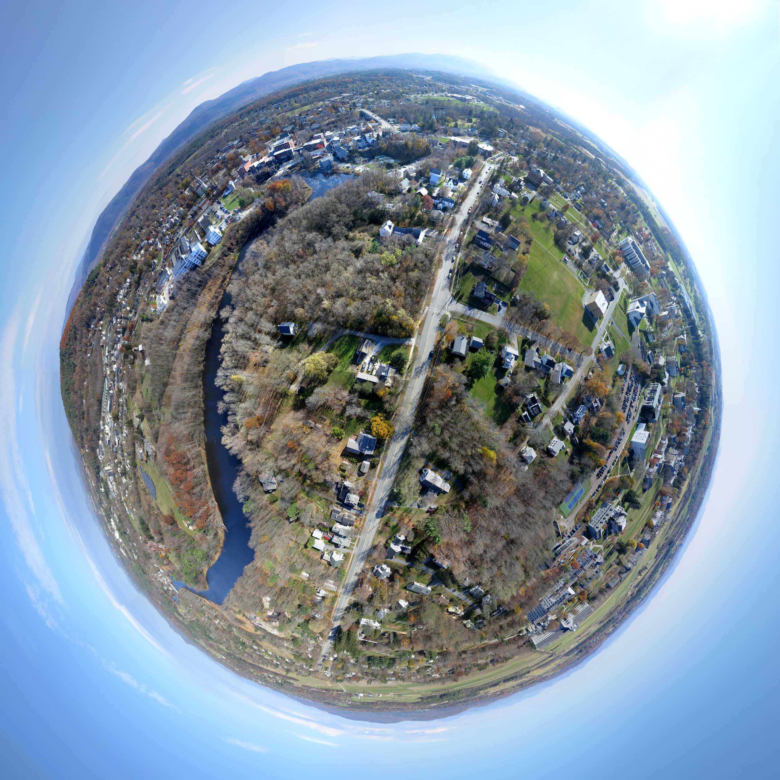
Above: Little planet projection of a panorama stitched from 22 photos taken from the wrong place at the wrong time in Middlebury, VT. Town on the left, gown on the right. November 3, 2015.
Yesterday's flight was mostly successful, but it won't be the last time I try to recreate the aerial view of Middlebury that L. R. Burleigh drew in 1886. I made several mistakes, both conceptual and logistical. I thought it would be good to get the camera closer to the village center than Burleigh imagined his bird's eye to be. I wanted to capture better detail of the buildings there, but that sacrificed the impact of creating an image that closely resembles the original.

Above: On the ground is the Fled which should have been in the air. One of many poor choices that day.
I also failed to get the camera high enough, because I selected the wrong kite. The Fled would have flown to 900 feet, but the Levitation Delta was sluggish when it got to about 600 feet, and I couldn't trust it to stay up there over people's houses with that much line out. Burleigh's view was probably from about 1000 feet, and you can tell that my camera needed to be higher. I made the flight in the morning, but the buildings at the heart of town were still backlit then, and the sky behind them was too bright. An hour later would have been better. So this was a reconnaissance flight. I now have a slightly better chance of nailing it next time.

Above: Burleigh's 1886 lithograph of Middlebury, Vermont (top), and my first attempt to reoccupy his mind's eye with my KAP camera. I should have been farther away, farther to the left, and higher. And later in the day would have been better. Burleigh obviously exaggerated the proximity and ruggedness of the Green Mountains.

Above: Detail of the views above. I really wanted to document what these buildings look like today, but the camera has to be much higher and farther away to recreate the view in Burleigh's lithograph.

Above: The nice thing about a 360° panorama is that the sun can be at the wrong angle for part of it, but it will probably be at the right angle for some other part. This is the Middlebury College campus to the southwest of the kite.

Above: GPS data recorded by the PowerShot S100 with 700 photos from the flight (workflow here). The red trace is on the way up and green is on the way down. The red trace seems to start in a tree, but that's because it starts in midair -- the camera did not start recording GPS data until a couple of minutes into the flight. In the distance are the traces from last week's flight in Bristol, nine miles away.

Above: Detail of the GPS traces. The blue segment is from 25 photos (one cycle of the Saturn V Rig) that were used to make the panoramas here. The camera did not move much during that 75 seconds.
The 360° panorama below can also be seen at photosynth.net.
Above: The full resolution half-spherical panorama stitched from 22 photos (three sky photos did not stitch). The same panorama is the source of all the views here.

Above: Burleigh was a contemporary of George Norris (of Bristol fame). Most of the views enumerated here were aerial views. Google Books makes a lot of this book available online.
Flight notes:
Camera:
- Model: PowerShot S100
- ISO: 80
- Shutter speed: 1/800 second (Tv)
- Focus: manual on infinity
- Focal length: 24mm (eq.)
- White balance: Sunny
- GPS: on
CHDK:
- Remote enabled: one push, quick
- The S100 has a shutter priority mode so CHDK is not needed for that
SkyShield:
- Version: 2.4 (3-switch DIP)
- Sketch: version 2.08sfm (beta)
- Mode: Mode 0 (for 24 mm lens, 25 photos/cycle)
- Power: 6 eneloop AAA
- Customization: The nadir tilt angle was changed from 20 to 11 so the camera was pointed straight down.
Flight:
- Kite: 9' Levitation Delta
- Wind: From S, 9 to 14 mph
- Duration: 38 minutes
- Photos taken: 741
Panorama stitching:
- Software: Microsoft ICE
- Post processing: ICE's "auto complete" feature was used to create extra sky to fill in missing areas in the Photosynth panorama. Some stitching errors in the little planet panorama were hidden in Photoshop. Panoramas at Photosynth cannot be passed through Photoshop so what you see there is what Microsoft ICE produced.
3 Comments
@cfastie- Have you or others done and/or documented any other work with historic aerial imagery? This is a subject I've been very much interested in for years. In fact my very first research note was for a project called the DIY Time Machine which proposed using a DIYBookscanner to digitize historic imagery to supplement grassroots mapping data. Also, somewhere I have a rough draft for a blog post covering the history of Kite Photography for panoramas etc... Anyway, I came across your post in the course of my current project wherein I'm trying to create a storymap to supplement a relative's experiences as a German refugee in WW2. Most of the material I've been trying to work with is in the form of wartime aerial reconnaissance imagery compiled by both sides. However, since such images were often taken from converted Spitfires or Mosquittos, they typically require orthorectification before they can be layered against modern satellite data. Warren and others will be happy to know that out of all available platforms, I've still found Mapknitter to be the best tool for this purpose. Has this been your experience as well? Are there other tools that you are aware of? Likewise, are you aware of any other current efforts within the PLOTS community that involves working with historical imagery?
Is this a question? Click here to post it to the Questions page.
Reply to this comment...
Log in to comment
Lots of people have used MapKnitter to place images that are not aerial photos they have taken. Some of these are older aerial photos which must be distorted to align with the ortho base image. The free distort tools in MapKnitter are good for this. I generally use PhotoShop to do that kind of thing so I have more control over blending photos together, but then I sacrifice georeferencing,
Google earth allows image overlays which can be scaled and rotated and stretched over the topography (main menu, Add/Image Overlay), but the images cannot be otherwise warped to compensate for an oblique angle of the photo. This could be done first and then overlain in Google Earth. That is inconvenient, but it then leverages Google Earth's powerful display and annotation capabilities.
Another Google Earth feature allows oblique photos to be viewed from the perspective of the camera that took them (main menu, Add/Photo). A dialog box opens so you can select a photo from your hard drive and then align it in 3D space to have it match the Google Earth landscape behind it. These alignment tools take some practice (okay, maybe a whole lot of practice). It helps if your location in Google Earth is close to the original camera location before you start the process, so it takes a few tries to dial it in. The photo will not align very well until you find the exact spot in the sky where the camera was and also adjust the field of view, tilt, and roll to match the camera.
Here is a kmz file of one oblique aerial photo of Middlebury that was added to Google Earth with Add/Photo. If you download this and click on it (and Google Earth is installed), Google Earth will show you the photo from the vantage point of the camera that took the photo. It does not match very well because I didn't spend enough time to make it match very well.
MiddFalls.kmz
I think this should work.
Chris
Reply to this comment...
Log in to comment
When the kmz file (attached in the previous comment) is loaded in Google Earth you must click "Exit Photo" to regain control of Google Earth. Then you can right click on the "MiddFalls" place in the places panel and click Properties and adjust the alignment of the photo. If you make it better, you can right click it again and "Save place as" a new name and share the new kmz around.
Reply to this comment...
Log in to comment
Login to comment.