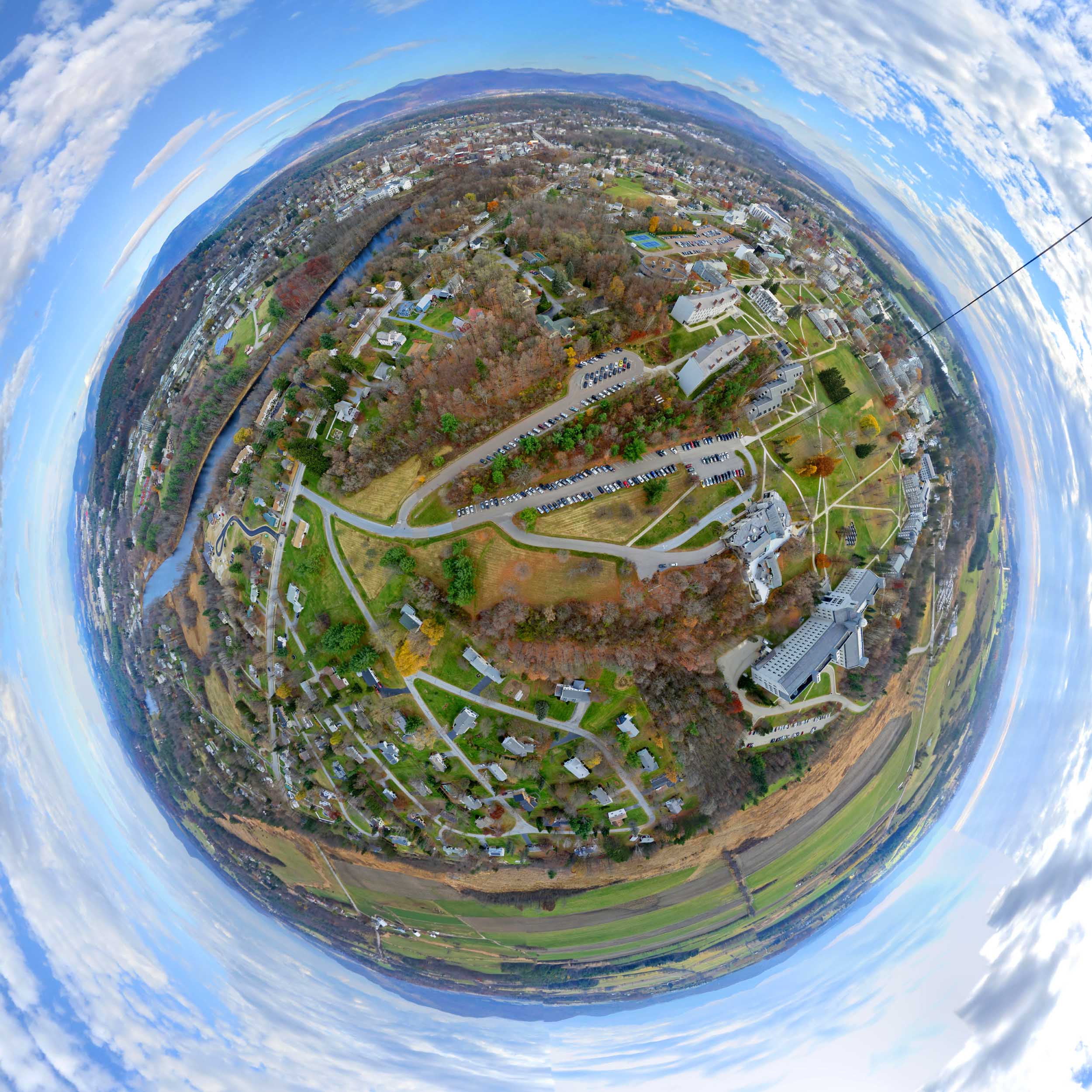
Above: Little planet projection of an aerial panorama stitched from 25 photos taken by a Canon S100 on a Saturn V Rig lofted by a Fled kite from the Middlebury College campus on November 5, 2015.
I took a closer look at L. R. Burleigh's 1886 bird's eye lithograph of Middlebury and decided that the northwestern corner of the Middlebury campus was the next place to try to reoccupy Burleigh's mind's eye. Thursday morning had another warm south wind, so I waited for the required afternoon sun and headed out.

Above: The temperature reached 70°F on Thursday with a lively 12-15 mph south wind.
Just as I was launching the Saturn V Rig a cloud bank moved in, so I moved the ISO from 80 to 200 and changed the shutter speed from 1/800 second to 1/640 second. All the photos were well exposed, but those settings resulted in soft images. The PowerShot S100 will produce some pretty nice photos, but it does not do its best work with those settings.

Above: The Fled lifted a Saturn V Rig with a PowerShot S100. The two servos pan or tilt the camera to a new position for each photo and cover the entire spherical scene (except the zenith) in 25 photos every 75 seconds. This was the first flight of the Saturn V Rig with the new case for six AAA batteries which is the standard configuration now.

Above: I launched from the biggest open area on the central campus (Battell Beach). The goal was to get the camera as far north (bottom of photo) as possible, and as high as possible. Note the lack of shadows – it was a pretty thick cloud bank. Stitched from 13 photos taken from the first blue man (see below). ICE's "perspective" projection was used.

Above: Burleigh’s 1886 lithograph (top) and a panorama stitched from three photos taken on Thursday from the northern extent of the flight. Burleigh’s view is from a higher perspective than my camera had, even though I had 950 feet of kite line out. But the azimuth is very close to the one Burleigh chose for his view. I tried all 10 projections Microsoft ICE allows, and Transverse Mercator made the best match.
Some of the details visible in both the old and new views are compared in an annotated version of this image at the KAPtery. That article also has a comparison of close ups of just the village in both views.

Above: Plan view of the camera tracks from the GPS data recorded with each photo (1421 data points). The kite was launched from the red man and walked to the lower blue man, the yellow man, the upper blue man, and then back to near the red man. The green track is when the kite was being hauled down. At each man, I waited for the Saturn V Rig to complete several cycles of 25 photos each before moving to the next location. That produced three clusters of photo locations (yellow circles). The spherical panoramas presented here were taken when the camera was near its northernmost extent (left, yellow trace). A KAPtery article includes an altitudinal profile of these GPS tracks.
Above: Full resolution spherical panorama stitched from all 25 photos of one pan/tilt cycle (yellow trace in previous graphics). These are the same 25 photos used to stitch the little planet panorama above.
So I know where the camera has to be to reproduce Burleigh’s view as closely as possible. It has to be a little farther north (maybe 100 feet) and quite a bit higher. The higher part just requires my really big spool of kite line (and the perfect wind). I might also have to change my strategy to increase the image quality. There is more information about how I might do this, and some additional images, in an article at the KAPtery.
Flight notes:
Camera:
- Model: PowerShot S100
- ISO: 200
- Shutter speed: 1/640 second (Tv)
- Focus: manual on infinity
- Focal length: 24mm (eq.)
- White balance: Sunny (didn’t think to change this)
- GPS: on
CHDK:
- Remote enabled: one push, quick
- The S100 has a shutter priority mode so CHDK is not needed for that
SkyShield:
- Version: 2.4 (3-switch DIP)
- Sketch: version 2.08sfm (beta)
- Mode: Mode 0 (for 24 mm lens, 25 photos/cycle)
- Power: 6 eneloop AAA
- Customization: The nadir tilt angle was changed from 20 to 11 so the camera was pointed straight down.
Flight:
- Kite: FLED
- Wind: From S, 10 to 17 mph
- Duration: 1 hour 14 minutes
- Photos taken: 1450 (1421 with GPS data)
Panorama stitching:
- Software: Microsoft ICE
- Post processing: There were lots of interesting clouds, so the sky stitched well and ICE stitched all 25 photos from almost every set I tried (about 10). Some stitching errors in the little planet panorama were hidden in Photoshop. Panoramas at Photosynth cannot be passed through Photoshop so what you see there is what Microsoft ICE produced. All 25 photos stitched into the big panorama by ICE were first brightened a bit in Lightroom, and a couple of the mostly sky photos were cropped to remove the underexposed ground surface below the horizon.
2 Comments
Recreating historical lithographs is a great application for KAP! The only one I could find for Cleveland is here: https://www.loc.gov/resource/g4084c.pm006872/ which would be a little challenging!
Reply to this comment...
Log in to comment
You don't have a boat? The wind should be great out there on the lake. Or it's the perfect application for your helikite. You might need to submit a NOTAM to fly that close to the airport though. Anyway, do you think much has changed since 1877?
Is this a question? Click here to post it to the Questions page.
Reply to this comment...
Log in to comment
Login to comment.