UPDATE Post-flight review of still and video imagery taken July 17, 2014.
Our Lighthawk flight on July 17th (thanks, pilot Jim Knowles!) has supplied us with 100s of photographs and a comparatively small amount of video footage. The overflight like last year, documented both the the GAC Chemical waste site and its surroundings and the greater West Penobscot Bay shore from Fort Point at the mouth of Penobscot River to Rockland Harbor - and back. The cooperating groundcrew on the flats didn't come happen. So it goes.
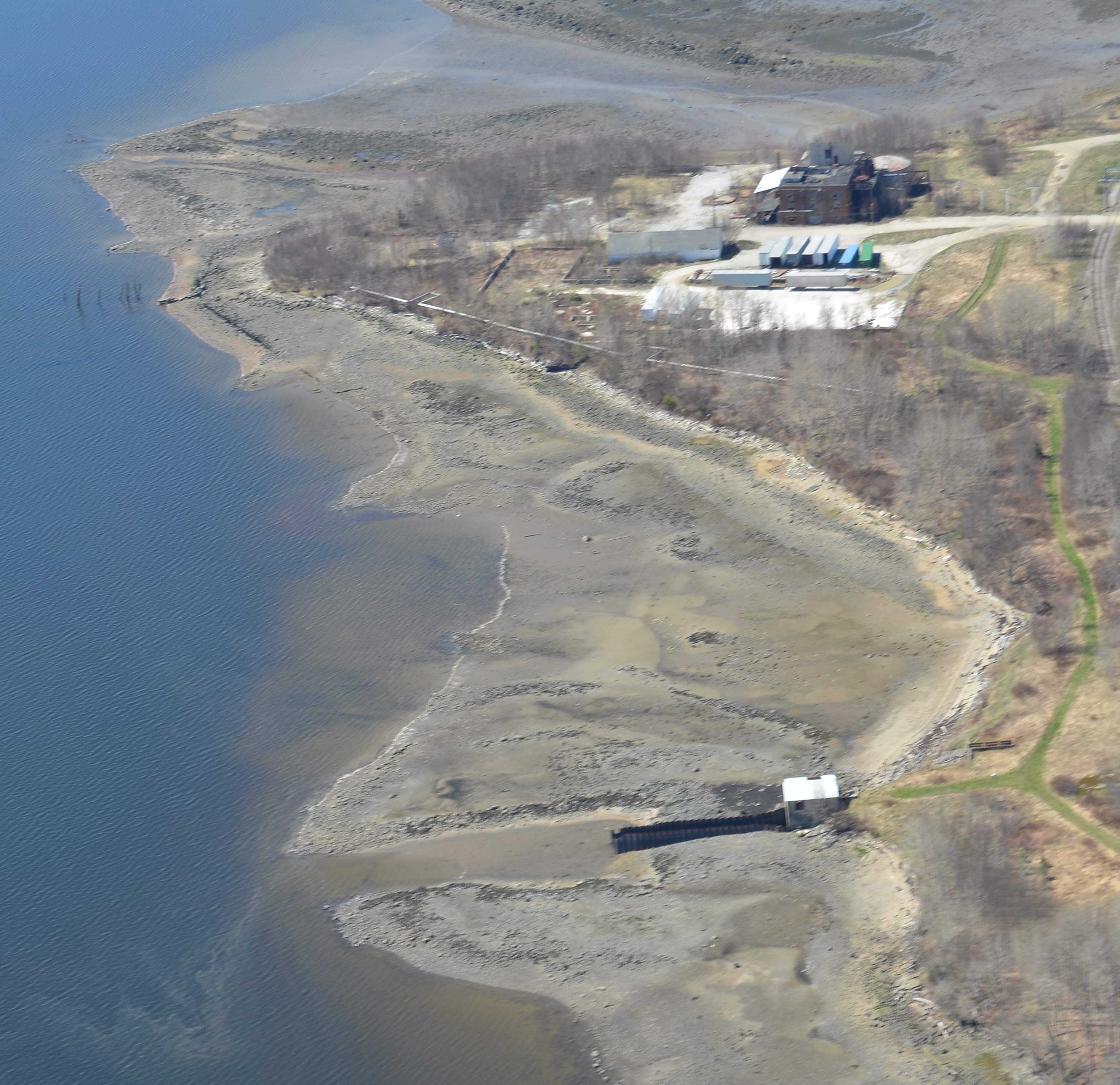
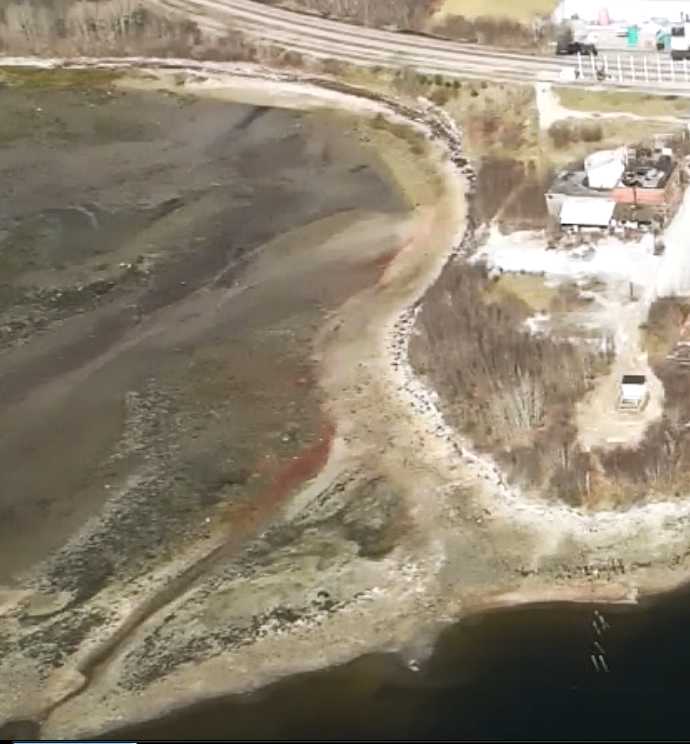
Observations with links to relevant photos (more to come!) Site overview: this 2013 aerial photo shows abandoned industrial waste covered peninsula at bottom, to left of RR line one of the plumes departing the south side of the peninsula, contained and channeled by old stonework ruins past the end of a rectangular sandbar protruding from the Sears Island causeway. * The waste plumes documented in this 2013 overflight photo are also found in this 2014 overflight photo See a Closeup image
Earlier posting:
WHAT
July 17th.from 8 am to noon .A LightHawk conservation pilot will fly us on repeated aerial mapping sensing runs over and around GAC Chemical's property and the adjoining cove, and greater Stockton Harbor. We'd like to deploy as many sensors from this aerial platform as possible in repeated runs around and over the site and the cove below.
This includes include coordinated air and ground activity. To wit, people on the intertidal flats scraping way the top 1/2" to one inch of sediments over a large rectangle along the three different mud flow channels that the eroding wastes travel within. So that the subsurface wastes become optically detectable, while paralleling undisturbed (by us) mud.
WHY
To date our aerial photography & videography of the site has been done with little to no systematics in mind. We propose to change that, thanks to what we're learning via PL about how people are developing & deploying DIY aerial sensors, are mosaicing photos together and more.
We will use the July 17th flight to systematically overfly the site and cove from as many angles and heights as allowed and deploy every information gathering device possible.
NEW INFO
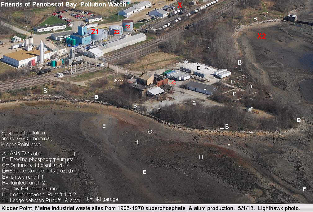
- NEW ACID HOTSPOT? a location was identified where, it is said, sulfuric acid tankers and tanker trucks are/were being rinsed out regularly into a gully leading straight to the beach then harbor. This is on the "cleaner" two-thirds of the GAC Shore, where the wooden walls are still holding up, more or less. See points X and X2 on this aerial photo Note the discoloration plume in the mud at X2
Of interest is that our January sediment testing had an anomalously low pH reading from a sample in its transect that was only a yard or two bayward of X2! We'd presumed this was a cleaner control area, as it is well around the point from the tainted cove. Surprise, surprise.
- BURIED WASTE OIL PIT ONSITE? Retirees say that a large waste oil lagoon was created behind an old repair shop onsite and then filled in with soil to a semisolid state, capped and forgotten. A now retired DMR marine ecologist, John Hurst, told me these "poison pockets" are regrettably common in Maine. Each unlined and slowly leaking into the local ecosystem. Question: Given a fair account of the location, can we detect from the air any signs of the wastes down gradient, as in altered vegetation, or discolored sand or mud? Old repair shop is labeled "J" in the aerial photo
NEXT STEPS
July 17th is not a very long from now. Let me know if you may be available or know someone who might. I will cheerfully bump myself from a flight if someone else has tech to deploy. Things to consider
A release form must be filled out, witnessed and sen to Lighthawk Emailed image of signed document is fine or mailed or faxed.
All flights are subject to last minute scrubbing if unsafe weather conditions occur.
Maximum passenger & gear weight per flight is 380 lbs. (3 thin folk or two of greater bulk or some mix thereof). If one person can operate two people's devices, that will increase the amount of sensing., too
Everyone will have an openable window to work from - possibly removable, which is better-if chillier.
The plane is a "wingover" configuration, so view down and obliquely is unobscured.
- As the flight begins before 9am, for those interested but a bit distant, sleeping bag and couch space and perhaps a spare bedroom or two, will be availabl.e should you prefer to arrive the night before.
There are many wastes leaking from the site - acids, phosphogypsum, bauxite red mud, petro-chemicals, Let's see if we can identify them by land air and mud.
1 Comments
hmmm... if its capped with soil, the waste pits should be subsiding-- especially if they're leaking. It's similar to identifying grave sites, where soil compaction and decomposition leads to pitting on the surface. https://publiclab.org/notes/eymund-diegel/11-9-2012/raising-dead-grassroots-mappers-help-look-america-s-first-veterans-cem
Reply to this comment...
Log in to comment
Login to comment.