WHY A VIRTUAL PENOBSCOT BAY?
Penobscot Bay is the heart of the New England lobster fishery, thanks to the fortunate coming-together at the mouth of Penobscot Bay of the Eastern Maine Coastal Current, the fresh waters of Penobscot River, and the Western Maine Coastal Current. The interplay of the three amid the complicated seafloors and archipelagos of this bay has made Penobscot Bay a lobster cornucopia; brackish at the narrow end, salty at its mouth See photo of two typical trawl survey catches at mouth of Penobscot Bay
Below are links to efforts at creating 3D representations of Penobscot Bay.It is my hope and anticipation that creating a 3D Penobscot Bay, properly populated with standard seasonal currents and thermoclines, updating monitoring data, seasonal inmigrations and outmigrations of present and historic fish invertebrate and unicellular species.
Maine DEP has already mapped nearly all recognized waste dumps, spills, wastewater treatment plantsand other ecologically impacting locations to google earth. MDEP updates it as they can.
Avatars would be important so that point of view fly-throughs are possible , with those avatars limited to organisms commonly found there,, with each species avatar being subject to limits of the type of bay animal they are, and to weather, currents and all the other variables. "Players" will have to learn how sense their prey and predators and landbased impacts like oil spill pollution within the virtual bay if they are to survive . To me the existing virtual efforts are rather primitive
More Simulations from woods hole -
A circulation animation I commissioned from a graphics designer to show the predominant currents of the Gulf of Maine, the flow of lobster larvae and the possible effect of putting floating windfarms in their path - instead of safely further out. (YOUTUBE)
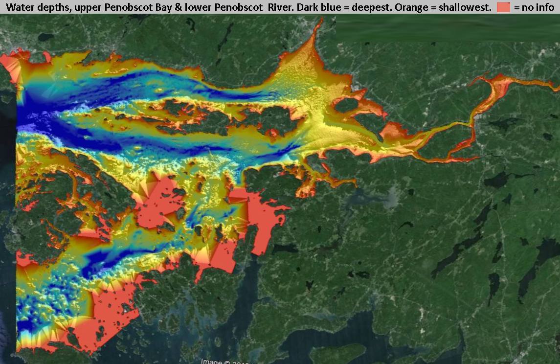
DATA FOR GULF OF MAINE that could be mapped to outer part of bay and nearby Gulf of Maine 1929 fishing ground data mapped for mid maine coast
Again,these are overly simple and lack interaction. We need a more "Game" style production with the greography populated by existing bathrymetry, then overlaid as above. Are there "game templates one can "fill in the blanks" with data and fill it with a vurtual ecosystem?
3 Comments
This would allow us to track impacts of chronic acid pollution, of the extent of dredging resuspension, of oil spill trajectories , historic dioxin and ongoing mercury waste spilling in a format where the impacts and potential ones can be seen at once. Thus better understood.
Reply to this comment...
Log in to comment
With or without participative avatars, the production and maintenance of animated 3D fly-thru bays or larger but semi-enclosed marine regions like the Gulf of Maine, that can be populated close to real time with seasonal species and water quality mixes and abundances - past and present - would answer limitations in the current delivery of GIS data applied to nature and pollution. In this era, slideshow and other linear presentations are unsatisfactory as the chief way of presenting data to non-scientists like our political decisionmakers. Instead, let's send them down and watch lobsters migrate , let them see the flow of mercury coming down Penobscot River and slowly entering the upper bay's surface sediments.. And all the good things too. I think Marshall McLuhan would've agreed.
Reply to this comment...
Log in to comment
Hello Ron, Check out the more recent comments on my KAP post- http://publiclab.org/notes/code4maine/06-25-2014/kap-test-for-invasives-monitoring-project as I may have stumbled onto an open source approach for incorporating 3D into grassroots mapping. I'm trying to figure out if its already been examined on PLOTs before, but I'll create a new research note if nobody else has.
Reply to this comment...
Log in to comment
Login to comment.