Staten Island's north shore
Staten Island's north shore is part of New York City and the Northeast region.
Concern about floodwater carrying pollution from former industrial and radioactive sites into adjacent neighborhoods has resulted in the Northshore Waterfront Conservancy and the City University of New York being awarded a 2014 Environmental Justice grant from NY State Dept Environmental Conservation. The project is to identify:
- which sites are actually contaminated,
- which sites are vulnerable to flooding,
- where contaminated floodwaters will / should flow after leaving those sites,
- what flood-resistant infrastructure has already been built, and
- what flood-resistant infrastructure is needed.
EJ orgs on Staten Island
North Shore Waterfront Conservancy
Reporting on Staten Island
The following articles are written by Melissa Checker:
“A Year After Superstorm Sandy, Turmoil Continues On Staten Island,” Gotham Gazette, October 23. 2014. http://www.gothamgazette.com/index.php/environment/4684-a-year-after-superstorm-sandy-turmoil-continues-on-staten-island
“Chicken Little, A Ferris Wheel and Disorderly Development on Staten Island’s North Shore,” Gotham Gazette, November, 2012 http://www.gothamgazette.com/index.php/topics/development/2133-chicken-little-a-ferris-wheel-and-disorderly-development-on-staten-islands-north-shore
“Another Natural Gas Controversy” Gotham Gazette, August 17 www.gothamgazette.com/article/environment/20100817/7/3337
“Staten Island's Toxic Stew”, Gotham Gazette, May 29 http://www.gothamgazette.com/article/environment/20090526/7/2923
“The Manhattan Project's Legacy on Staten Island” Gotham Gazette, June 4 http://www.gothamgazette.com/blogs/wonkster/2009/06/04/the-manhattan-projects-legacy-on-staten-island/
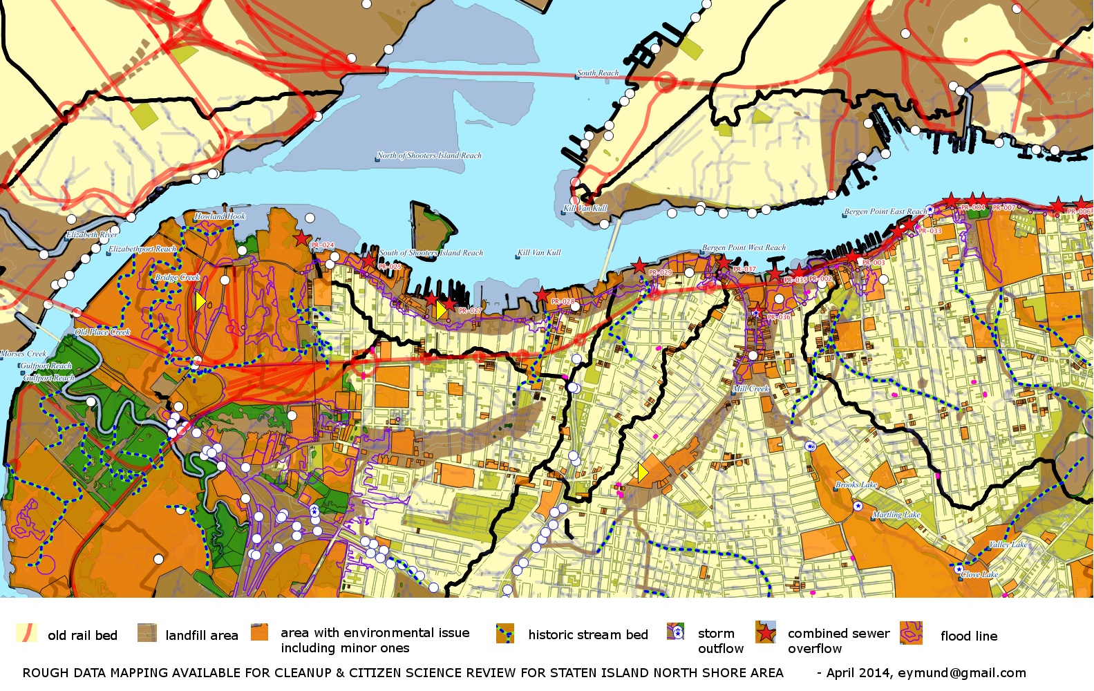
About the map at the top of this page:
Notes from the cartographer Eymund Diegel
- rough landfill areas
- rough buried stream beds
- old rail lines
- approximate wetlands
- FEMA flood lines
- surface runoff corridors
- partial water quality outflow points (sewers, storm drains)
- rough estimation of lots with environmental issues
Environmental "problem areas" includes ongoing remediation activities. "Problem Lots" were compiled by merging NYSDEC ( Dept of Environmental Conservation, NYCMOER (Mayors Office of Environmental Remediation) and USEPA (Environmental Protection Agency) listed environmental contamination or remediation site points with MapPluto NYCDCP (City Planning) lot lines. "Problem" data points include things like heating oil tanks and bridge repairs over sensitive wetland areas). The fact that a lot is colored orange does not mean that it is actually polluted (some of course definitely will be) or that pollution mapping is comprehensive. More detailed mapping would review source data and research each area to make appropriate data corrections. Map is purely meant to give rough idea of potential priority study areas.
Other data sources:
- Toxic Release Inventory, EPA, although it's self-reported, the pattern can also reveal where gaps are
- NY State Department of Environmental Conservation: Historical Brownfield Sites
- Mayor's Office for Environmental Remediation has another database of "problem" lots, tagged as "E" designation which requires action before being redeveloped.
- Library of Congress Museum of American Memory has historical photographs of major infrastructure and architecture projects, like the Bayonne Bridge. This may also show the original uses of the surrounding land. http://www.loc.gov/pictures/item/nj1025/
Bayonne Bridge, Staten Island North Shore, 1985

- Historical aerials: 1924, 1951, 1974, 1991, 2010
Bing 2010 Aerial

Bing 2010 Aerial zoomed in near foot of Bayonne Bridge:

Bing 2010 Aerial zoomed in near foot of Bayonne Bridge, color enhanced with free GIMP photo software to look at unusual color patterns in water:

Citizen Grassroots Mappers could use digital cameras tied to kites or balloons to gain a better understanding of potential unmapped outflow pipes or buried streams. Comparing them with the historical data will inform a better understanding of the site.
Below: 1894 Natural Science Association Map of Staten Island which shows now buried natural features.

Design Proposals for the Northshore
- Some interesting 2010 research for the Mariners Marsh Howland Hook area by dland studios gives good information on shoreline ecosystems: 2010_Howland_Hook_Sponge_Park_DLand_2010_P1018.pdf
- New York City Economic Development Coalition St. George Waterfont Redevelopment Project


