Staten Island northshore
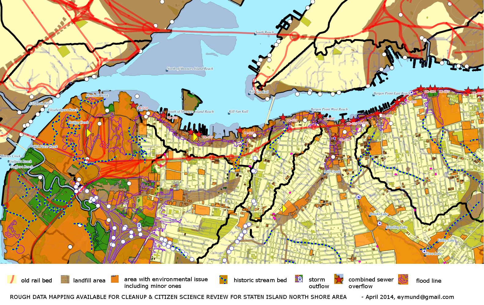
Concern about floodwater carrying pollution from former industrial and radioactive sites into adjacent neighborhoods has resulted in the Northshore Waterfront Conservancy and the City University of New York being awarded a 2014 Environmental Justice grant from NY State Dept Environmental Conservation. The project is to identify:
- which sites are actually contaminated,
- which sites are vulnerable to flooding,
- where contaminated floodwaters will / should flow after leaving those sites,
- what flood-resistant infrastructure has already been built, and
- what flood-resistant infrastructure is needed.
EJ orgs on Staten Island
North Shore Waterfront Conservancy
Reporting on Staten Island
The following articles are written by Melissa Checker:
“A Year After Superstorm Sandy, Turmoil Continues On Staten Island,” Gotham Gazette, October 23. 2014. http://www.gothamgazette.com/index.php/environment/4684-a-year-after-superstorm-sandy-turmoil-continues-on-staten-island
“Chicken Little, A Ferris Wheel and Disorderly Development on Staten Island’s North Shore,” Gotham Gazette, November, 2012 http://www.gothamgazette.com/index.php/topics/development/2133-chicken-little-a-ferris-wheel-and-disorderly-development-on-staten-islands-north-shore
“Another Natural Gas Controversy” Gotham Gazette, August 17 www.gothamgazette.com/article/environment/20100817/7/3337
“Staten Island's Toxic Stew”, Gotham Gazette, May 29 http://www.gothamgazette.com/article/environment/20090526/7/2923
“The Manhattan Project's Legacy on Staten Island” Gotham Gazette, June 4 http://www.gothamgazette.com/blogs/wonkster/2009/06/04/the-manhattan-projects-legacy-on-staten-island/
Other data sources:
- Toxic Release Inventory, EPA, although it's self-reported, the pattern can also reveal where gaps are
- NY State Department of Environmental Conservation: Historical Brownfield Sites
- Mayor's Office for Environmental Remediation has another database of "problem" lots, tagged as "E" designation which requires action before being redeveloped.
- Library of Congress Museum of American Memory has historical photographs of major infrastructure and architecture projects, like the Bayonne Bridge. This may also show the original uses of the surrounding land.
Design Proposals for the Northshore
- 2010_Howland_Hook_Sponge_Park_DLand_2010_P1018.pdf
- New York City Economic Development Coalition St. George Waterfont Redevelopment Project


