After a long wait, I've finally integrated @xvidun's feature of automatically placing images on a MapKnitter map if they have GPS EXIF metadata -- that is, if they've been taken from a smartphone or camera with a GPS. I implemented only placement in latitude/longitude so far, but we should be able to expand this to figure out rough compass heading and altitude with a bit of extra work.
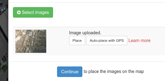
To use this new feature, just drag images which have GPS EXIF data in them onto a MapKnitter map, then click "Auto-place with GPS". MapKnitter does the rest!
Watch this video to see it in action, or try it yourself:
8 Comments
I was very excited to try this, but MapKnitter gave an error because I did not enter a lat and lon for the map. That seemed to defeat the purpose.
Reply to this comment...
Log in to comment
Ah, you do have to create a map first. Then you can start dragging in images. Do you think that could be more clear?
Is this a question? Click here to post it to the Questions page.
Reply to this comment...
Log in to comment
It sort of re-orders things to be able to upload an image before defining a map to upload it to, but I think we could do some trickery to have it create the map and place the first image in the same step... is that worth it?
Is this a question? Click here to post it to the Questions page.
Reply to this comment...
Log in to comment
Any workflow will be great. The workflow that I imagine is usually not the one that is available. That is probably good for the rest of the world. I just entered 1, 1 for lat and lon and it let me drag in an image and then it correctly auto placed it. So that is almost as good as I imagined.
Reply to this comment...
Log in to comment
:-) glad to hear it!
Reply to this comment...
Log in to comment
I'm a little worried that MapKnitter will always think that lat =1 and lon=1. But it seems to find the map the next time it is opened.
Reply to this comment...
Log in to comment
In a dream universe, I'd love to see the altitude information compared against local altitude data from the USGS so that images were dropped with the appropriate scaling. That's probably a whole new feature though.
even more complicated: a take at a quick projection given the camera orientation data.
Posted to github as feature request!
Reply to this comment...
Log in to comment
Done! Auto-scaling and auto-compass now work. @liz check it out!
Reply to this comment...
Log in to comment
Login to comment.