Image Credit: USGS
What I want to do
I want to understand where frac sand is being mined and why. I started from the Iowa Policy Project Project document Digging Deeper on Frac Sand Mining because I was intrigued by this map I found in there from the Iowa Geologic Survey:

It looked like the exposed sandstone follows river valleys. which makes sense, they're major points of erosion.
The same pattern is visible in Minnesota.

Tony Runkel, Minnesota Geological Survey, Via the Sandpoint Times
My attempt and results
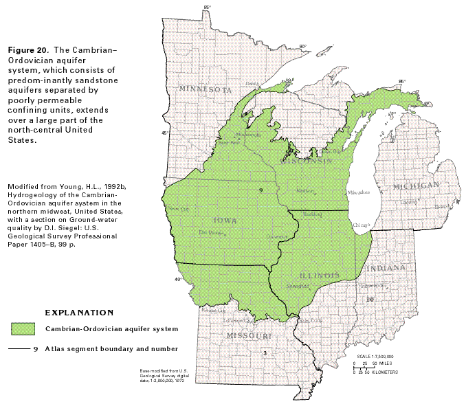
Through the US Geological Survey's Groundwater Atlas, I discovered is that the Upper Midwest contains a large sandstone aquifer made up of interlinked sandstone deposits from the Cambrian & Ordivician periods, and appropriately called the Cambrian-Ordivician Aquifer System. The aquifer is especially permeable because the limestone is made of fine, well-ground sand. These same properties make the sand valuable as frac sand.
The deposits are known as the St. Peter, Jordan, and Wonewoc deposits, visible in this USGS Map:

Wisconsin Watch's map shows that the upper edge of the Cambrian-Ordivician is being mined heavily:

Questions and next steps
I want to share a few notes from the same Iowa Policy Project Project's Digging Deeper on Frac Sand Mining
The bluffs are near streams, these streams are the bedrock of the local trout fishing tourist industry.
The Wisconsin DNR has sent noncompliance letters to 80-90% of mines they have visited.
"the entire area where sand might be mined is underlain by permeable rocks with only a few remnants of glacial material atop them, so the groundwater is very vulnerable to contamination." --Iowa State Geologist Bob Libra
A closed-loop (water recycling) industrial frac sand facility operating will require well capacity ranging from 700 to1380 gallons per minute, and an open loop system will require 2000-3700gpm.
Large water withdrawals may have regional effects, such as those used to wash sand.
Ironically, water recycling uses polyacrylamide as a settling agent, and it breaks down into acrylamide, a "probably carcinogenic" chemical, according to the EPA.
3 Comments
It's nearly impossible to separate the effects of irrigation hi-cap wells from the silica wash plants. Also, withdrawing large amounts of water for sand mining or industrial farming increases the flow of groundwater, both speed and quantity, and so, groundwater under these conditions is much more likely to pick up bacteria, nitrates, atrazine, and, worst of all, arsenic. The St. Peter sandstone has spots of concentration of arsenic; there's a lot more in Eastern Wisconsin. Nevertheless, arsenic is showing up in some places-anecdotal evidence.
Reply to this comment...
Log in to comment
Wisconsin watch railway map:
Reply to this comment...
Log in to comment
Minnesota DEP maps:
Reply to this comment...
Log in to comment
Login to comment.