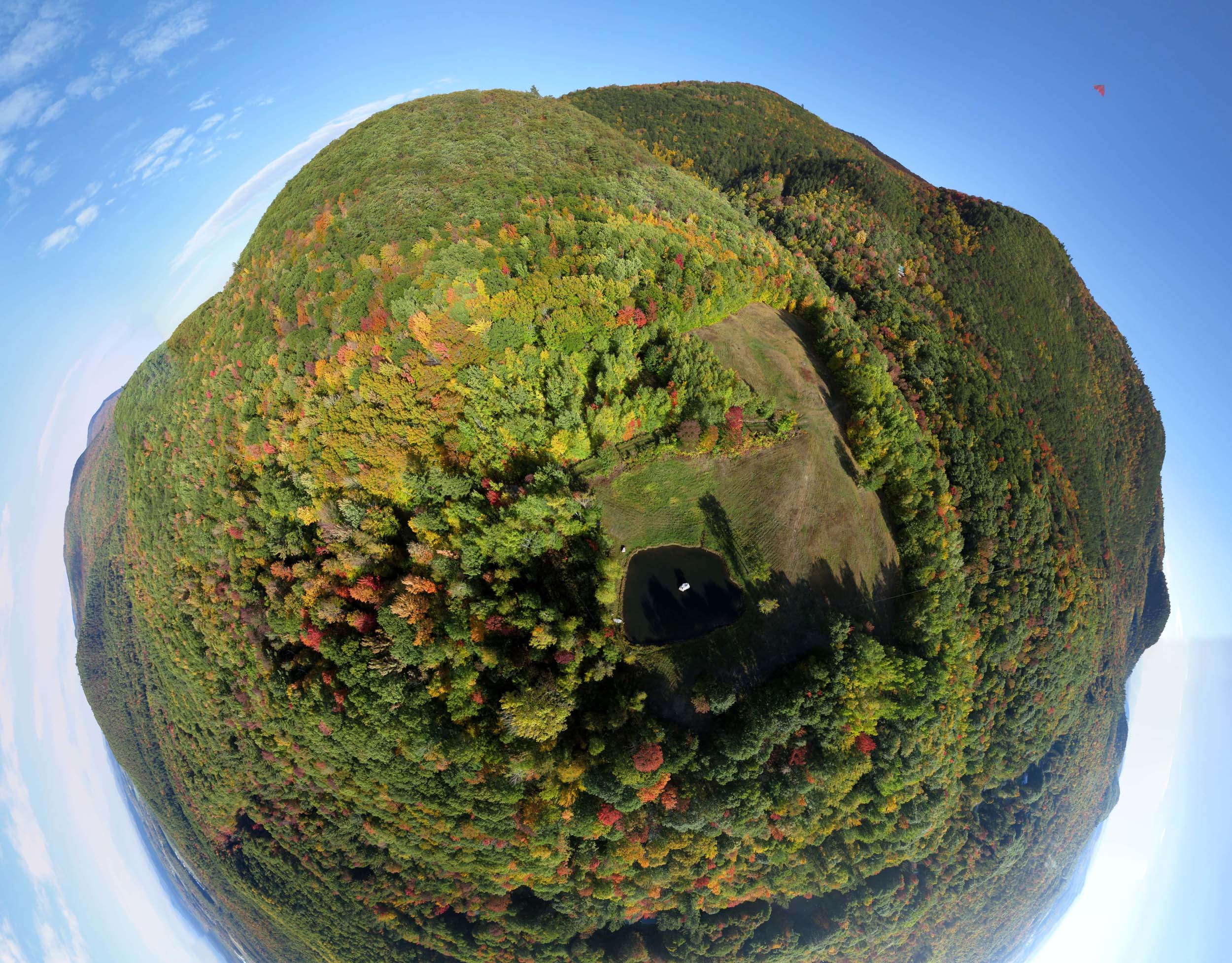
Above: Planet LEAFFEST. A stereographic projection of a half spherical panorama above Lone Rock Pond.
Sunday's practice flight of the Nighthawk delta from Paul's Fishing Kites returned some nice photos. I flew a Saturn V Rig with a PowerShot S100 for an hour and 15 minutes an captured 1474 photos. The SD card filled about five minutes before I landed the rig. That happened at 5:15 PM and the low sun was behind clouds, so many of the later photos are underexposed.

This could not have been a more perfect day for kiting, except that most of the LEAFFEST people had already headed back to Boston.
For the first time, I had the S100 record GPS coordinates for each photo. I have kept the GPS feature turned off previously because it uses extra battery power and I didn't know how much it would shorten the session. CHDK says the camera battery is still at about 40%, so it appears that the GPS does not use very much power. I will probably have it on by default from now on.

The Saturn V Rig with SkyShield autoKAP controller and PowerShot S100.
The pan/tilt mode running on the SkyShield autoKAP controller was capturing 25 photos during each cycle which covered everything except the zenith. Each cycle took 72 seconds, so a photo was taken about every three seconds.

Mount Moosalamoo beyond Lone Rock Pond. Stitched from three photos. The red maples are at their peak color, but most other trees have a long way to go. This is the latest fall color I can remember.
Below is a stitched spherical panorama from one cycle of 25 photos. There are 59 of these cycles from this flight so many other panoramas are possible.
Google Chrome does not properly display these embeds from Photosynth (Photosynth is a Microsoft project). Other browsers work better.
Flight notes:
Camera:
- Model: PowerShot S100
- ISO: 80
- Shutter speed: 1/800 second (Tv)
- Focus: manual on infinity
- Focal length: 24mm (eq.)
- GPS: on
SkyShield:
- Version: 2.4 (3-switch DIP)
- Sketch: version 2.08sfm (beta)
- Mode: Mode 0 (slower version of mode with 4 tilt angles, 8 pan positions at and above the horizon, 6 below the horizon, and 3 at nadir, 25 photos per cycle)
- Customization: The nadir tilt angle was changed from 20 to 11 so the camera was pointed straight down.
Flight:
- Kite: PFK Nighthawk with kite line attached to apex grommet
- Wind: From south, 15-18 mph with 20-25 mph gusts
- Duration: 75 minutes
- Photos taken: 1474
Panorama stitching:
- Software: Microsoft ICE
- Post processing: No adjustments were made to any photos before stitching.
- I have lots of other sets of 25 photos (one full pan/tilt cycle) to try.
4 Comments
Very nice results Chris. Good to learn that the gps isn't a big power drain. Having the GPS turned on, not so much for panoramas, but for use in Mapknitter where the GPS tagged images can be autoplaced can be very powerful.
Reply to this comment...
Log in to comment
Wow, this makes me really nostalgic about home!
Reply to this comment...
Log in to comment
@dbenjamin You mean you hail from Planet LEAFFEST? @patcoyle I guess I will have to try the new MapKnitter feature. I couldn't get very many nadir photos to stitch in ICE. I walked all around that clearing, so I have a little bit of coverage.
Is this a question? Click here to post it to the Questions page.
Reply to this comment...
Log in to comment
Well, I've never been to LEAFFEST but I grew up in the Mad River Valley :D
Reply to this comment...
Log in to comment
Login to comment.