We're happy to announce that Patagonia will be supporting a proposal that we submitted, Gulf Coast Restoration--monitoring wetlands through community-led aerial imaging, between October 2013 and October 2014.
There will be a number of opportunities to get involved in this project including participating in mapping trips and helping to stitch maps. If you're interested in getting involved, please 1) join the plots-gulfcoast@googlegroups.com list and 2) send an email to shannon@publiclab.org. We'll be using a wiki page to post updates and track the different mapping sites: http://publiclab.org/wiki/barataria-bay-mapping-project. A full list of current Gulf Coast projects can be found here: http://publiclab.org/wiki/gulf-coast.
Basics of the project:
Summary: Public Lab will be working on a dedicated restoration monitoring of the Barataria wetlands area, a socially and ecologically important region of the Gulf Coast impacted by the BP oil spill, using low-cost, open-source technology. This project will allow the Public Lab community to further develop the Gulf Coast restoration monitoring archive while expanding the support and volunteer base in the Gulf Coast, renewing our commitment to the communities that brought Public Lab together and continue to inspire our work.
Four anticipated results: 1) Twenty sites mapped and annotated with on the ground/water observations and indicators with leadership from Public Lab community members; maps will be georectfied to allow for easy comparison with maps made of the same sites in the immediate wake of the BP oil disaster. 2) Twenty maps created and hosted online by Public Lab; Public Lab community members will be trained on the open source map making software, MapKnitter, by Public Lab staff; community members will also learn the steps for posting completed maps on the Public Lab Map Archive for easy public access. 3) Twenty maps posted to Google Maps and Google Earth via existing relationship with Google Earth Outreach team with public domain licensing. 4) 10+ Public Lab community members will be trained on aerial imaging, map making and infrared techniques based on Public Lab’s DIY, open source tools and techniques.
Proposed Timeline
October 2013: Initial community planning session and review of existing Barataria Bay maps and data.
October-December 2013: One trip per month with three sites mapped per trip. During this time, ten sites will be mapped. There will be three MapKnitter trainings held during this period.
January-February 2013: Stitching of first ten sets of imagery.
March-May 2014: One trip per month with three sites mapped per trip. During this time, ten sites will be mapped. There will be three MapKnitter trainings held during this period.
May 2014: Final work on stitching maps and accompanying narrative information.
June 2014: Online archive and completed narratives of maps published at www.publiclab.org
July/August 2014: Creation of Fall 2014 issue of Grassroots Mapping Forum, dedicated to coverage of the project; paper copies distributed to area libraries, community centers, etc.
Beyond August 2014: We will work to establish this as a yearly project so that 1) changes over time can be documented at 20 locations in Barataria Bay and 2) people can use technical skills learned during the Patagonia funded phase of the project to map self-determined sites of community concern.
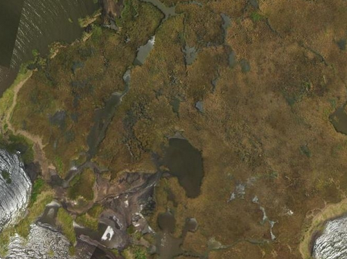
Importance of this site and project history: Located 40 mile south of New Orleans, the Barataria Bay wetlands are an important resource providing habitat to rare wildlife, recreational opportunities to people, and water filtration to the Gulf of Mexico. The Bay is essential locally as fish habitat, a site of water denitrification, and a tropical storm buffer for millions of Gulf Coast residents. Globally, Barataria Bay’s wetlands are important for sequestering carbon and as a layover for migratory birds. Between 2010 and 2011, Public Lab worked with the Louisiana Universities Marine Consortium (LUMCON) to track wetland loss and recovery in Barataria Bay using open-source, low-cost aerial photography techniques. However, since our initial imaging, our surveying of the Bay has been ad-hoc. With the support of Patagonia, Public Lab will be able to systematically survey the Bay and empower our collaborators with the tools and skills to maintain and expand their own aerial surveying and ground truthing efforts. This project will monitor rates of wetland loss versus recovery in Barataria Bay using our DIY aerial photography and near-infrared camera technologies, enabling local conservation organizations to advocate for the use of additional resources to rebuild the fragile wetlands, as well as measure progress of ongoing restoration efforts.
Building a long-term aerial image record of Gulf wetlands is crucial to understanding the dynamics of wetland loss and recovery. However, building these records has traditionally relied on skilled professionals, expensive equipment, and proprietary methodologies which, even in the best cases, result in infrequent, low-resolution images. Public Lab’s aerial imaging tools and techniques stand in stark opposition to these traditional methods, relying instead on inexpensive, simple balloon and kite photography techniques. Our DIY approach to aerial imaging allows conservation and community organizations to build image records of specific sites at specific points in time, illustrating wetland loss and recovery at high resolution, with richer context and timelines.
Sites at Barataria Bay are particularly appropriate for this project as they received varying amount of damage from the BP Oil Disaster and have become parts of various recovery projects since then. Systematically monitoring these sites over time will provide valuable information on the recovery of these areas, providing important ecosystem-wide information. Additionally, we work with the Gulf Restoration Network (GRN), using the maps to help communicate to the public more effectively about wetlands. A birds’ eye perspective is needed to see the wetlands because the land’s low relief prevents a clear view from any position on the ground. Our long-term map series will be a vital resource for GRN as they advocate for the recovery of Barataria Bay as an important ecological, economical and cultural resource for the Gulf Coast.
0 Comments
Login to comment.