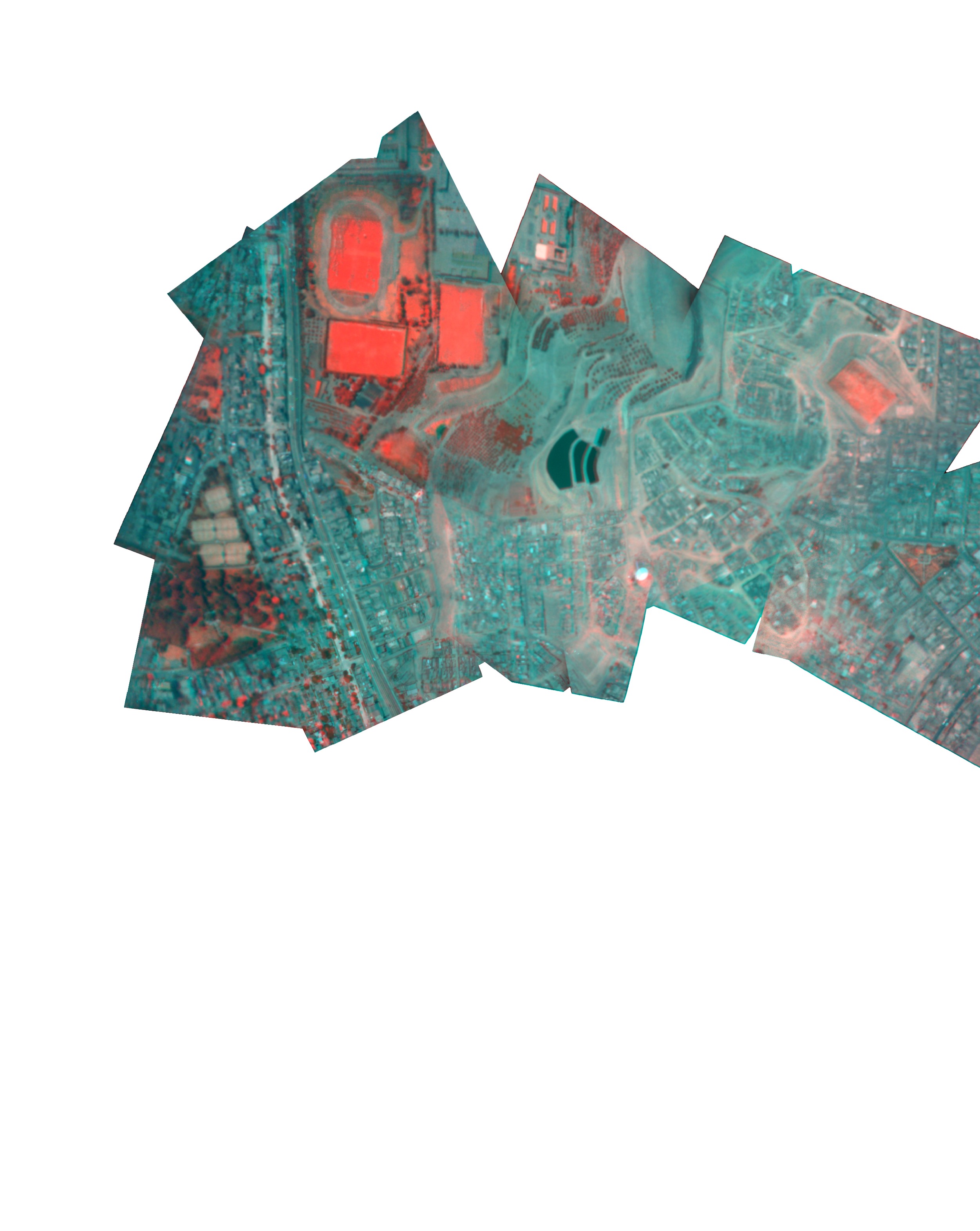
Lima, Peru (Infrared)
Mapped by Jeffrey Warren, Roxana Garrido, Morflex, Diego Rotalde, FabLabLima
Cartographer: Jeffrey Warren
Published by warren
-12.136478977990128 N, -76.97399975585003 E
355 views
Capture date: 2011-01-18T00:00:00
Publication date: 2011-01-26T00:00:00
License: Public Domain
Mapped by Jeffrey Warren, Roxana Garrido, Morflex, Diego Rotalde, FabLabLima
Cartographer: Jeffrey Warren
Published by warren
-12.136478977990128 N, -76.97399975585003 E
282 views
Capture date: 2011-01-18T00:00:00
Publication date: 2011-01-26T00:00:00
License: Public Domain
Notes
We flew at the athletic fields of Ricardo Palma University, on east side of Lima, and after a turbulent flight, the string broke, and the camera flew off, leaving us depressed and exhausted.
We had built a large airfoil-shaped balloon from three sleeping bags tied together with a 2 meter wide, 1/2 inch thick PVC tube which we found near the field. It generated so much lift in the light winds that it broke right through the 50-pound dacron kite string and flew away.

Luckily we'd put Beno's name and phone number on the camera rig, and he got a call that night; a friend picked up the camera 15 miles south of the launch site, and it was full of imagery from around 2 miles up (estimate). Amazing!
This camera had a bifocal filter, half infrared pass, half visible light pass. You can read more about this infrared balloon technique here:
http://publiclaboratory.org/tool/near-infrared-camera http://publiclaboratory.org/wiki/ndvi
Cartographer notes
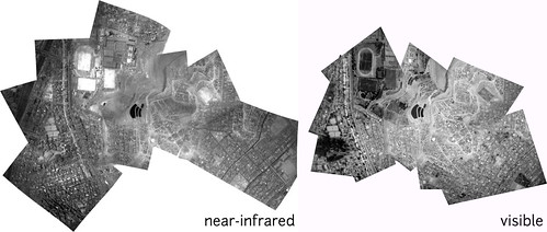
This flight was unique because it was the first infrared/visible multispectral camera we'd attempted to fly on a high altitude flight. With the lucky break of recovering the camera even though the string broke, this dataset was amazing to work with -- I spent some hours making both an infrared and a visible stitched image, shown here:
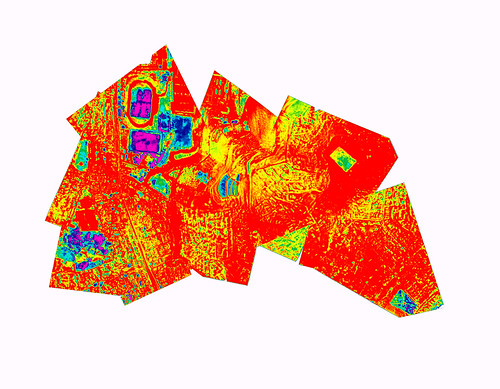
An alternate version of this is viewable here, using a heat-map color gradient to represent the data using the NDVI, or Normalized Differential Vegetation Index technique:
Notes
We flew at the athletic fields of Ricardo Palma University, on east side of Lima, and after a turbulent flight, the string broke, and the camera flew off, leaving us depressed and exhausted.
We had built a large airfoil-shaped balloon from three sleeping bags tied together with a 2 meter wide, 1/2 inch thick PVC tube which we found near the field. It generated so much lift in the light winds that it broke right through the 50-pound dacron kite string and flew away.
Luckily we'd put Beno's name and phone number on the camera rig, and he got a call that night; a friend picked up the camera 15 miles south of the launch site, and it was full of imagery from around 2 miles up (estimate). Amazing!
This camera had a bifocal filter, half infrared pass, half visible light pass. You can read more about this infrared balloon technique here:
http://publiclaboratory.org/tool/near-infrared-camera http://publiclaboratory.org/wiki/ndvi
Cartographer notes
This flight was unique because it was the first infrared/visible multispectral camera we'd attempted to fly on a high altitude flight. With the lucky break of recovering the camera even though the string broke, this dataset was amazing to work with -- I spent some hours making both an infrared and a visible stitched image, shown here:
An alternate version of this is viewable here, using a heat-map color gradient to represent the data using the NDVI, or Normalized Differential Vegetation Index technique:
0 Comments
Login to comment.