Chandeleur Islands (Northeast), Louisiana
Mapped by Adam Griffith
Cartographer: Stewart Long
Published by warren
29.958998788212572 N, -88.81829998470626 E
154 views
Capture date: 2010-05-18T00:00:00
Publication date:
License: CC-BY
Mapped by Adam Griffith
Cartographer: Stewart Long
Published by warren
29.958998788212572 N, -88.81829998470626 E
116 views
Capture date: 2010-05-18T00:00:00
Publication date:
License: CC-BY
This imagery was contributed by Adam Griffith on behalf of the Program for the Study of Developed Shorelines, Western Carolina University
http://psds.wcu.edu http://www.coastalcare.org
Notes
Adam Griffith, of the Program for the Study of Developed Shorelines at Western Carolina University, conducted several Gulf of Mexico aerial overflights and shared aerial imagery with the mapping project.
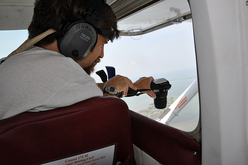 The flights were typical of DIY Cessna imagery collection. The Camera is held in approximate “geodata position” by a rubberized cabinet clamp. The camera operator stays quite busy though by holding the rig to dampen vibrations, shooting images, and communicating with the pilot. All this is happening with the window wide open and the plane travelling 90-150 MPH, making it quite noisy in the cabin.
Cartographer notes
Here is a great video of Stewart Long actually stitching these images together into a map in Photoshop. He later used GDAL to georectify it:
Notes
Adam Griffith, of the Program for the Study of Developed Shorelines at Western Carolina University, conducted several Gulf of Mexico aerial overflights and shared aerial imagery with the mapping project.
The flights were typical of DIY Cessna imagery collection. The Camera is held in approximate “geodata position” by a rubberized cabinet clamp. The camera operator stays quite busy though by holding the rig to dampen vibrations, shooting images, and communicating with the pilot. All this is happening with the window wide open and the plane travelling 90-150 MPH, making it quite noisy in the cabin.
Cartographer notes
Here is a great video of Stewart Long actually stitching these images together into a map in Photoshop. He later used GDAL to georectify it:
1 Comments
I added a timelapse video of Stewart stitching this map together -- it's amazing to see the process occurring before your eyes. Make no mistake, it took hours.
Reply to this comment...
Log in to comment
Login to comment.