The Mission of GLAM: Gowanus Low Altitude Mappers
Published in 2013 Grassroots Mapping Forum#4.
Order a copy or subscribe online.
written by GLAM members
photo credit: Gena Wirth
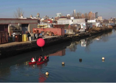
In line with the Conservancy’s mission to provide the community with accessible information related to the Gowanus Canal Superfund, the Gowanus Low Altitude Mapping (GLAM) project aims to collect accurate and current base information for the canal and adjacent areas. Since January of 2011, we have hosted seasonal mapping ventures jointly with the local chapter of Grassroots Mapping and community members. These efforts contribute to monitoring water quality, surveying surrounding vegetation, and documenting the evolving scenery of the Gowanus Canal and its environs; these data additionally inform the Conservancy of potential green spaces surrounding the canal.
To date, the Conservancy has completed a four-part set of seasonal imagery, available in our archive on Public Laboratory’s website. We’ve established a number of gardens along the canal as part of our stormwater management initiative; using an Infragram, we’ll be able to identify vegetative areas that are flourishing, in addition to spaces that need improvement.
GLAM can be summed up by its provision of environmental justice through crowd-sourced initiatives. A notable major breakthrough occurred in October of 2012, during a Clean & Green volunteer event at the Salt Lot. After a day of kite mapping and sorting through photos, volunteers found a milky white plume emitted near the Whole Foods shopping center and public waterfront park construction site. The Conservancy immediately notified Whole Food building contractors, the New York State Department of Environmental Conservation (NYSDEC) who are responsible for water pollution, and the Environmental Protection Agency (USEPA) who were managing a pipe outflow and pollution mapping survey for the Superfund cleanup. All parties quickly responded to the alert, epitomizing the important role of grassroots mapping as a watchdog medium.
GLAM, like all of the Conservancy’s projects, incorporates community involvement. We are fortunate to have dedicated mapping volunteer coordinators who develop and lead mapping efforts. Our volunteers have ranged from individuals who have had no prior association with the Gowanus Canal Superfund, to community members who are heavily involved in public discussions of the Proposed Cleanup Plan.
The Conservancy hopes to develop a more accessible and visually interactive map archive, providing a timeline of photos that the public can easily reference. Canal cleanup is slated to occur within the next few years, not only changing the historically industrial landscape drastically, but also affecting surrounding neighborhoods. Now more important than ever, the Conservancy will further establish itself as a watchdog entity, ensuring the cleanup process is as transparent as possible. Using community driven grassroots mapping, we hope to further promote public awareness of the potential to revive an otherwise neglected canal in Brooklyn.