Connecting with our Landfills by Nicholas Johnson
by Nicholas Johnson
Published Q3 2014 in the Grassroots Mapping Forum #6 Order online
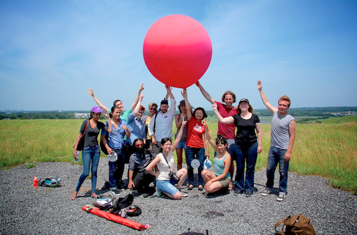
Image Credit: Shastine Van Vugt. ITP Camp 2013 balloon mapping excursion at Freshkills Park, Staten Island, June 24th, 2013.
For most of us, a landfill is a far away place that we know exists and we think we understand its purpose, but we never give it a second thought. For others, landfills lie close to home, literally. They are seen just beyond the tree line or beyond the litter filled fence that separates the public from the landfill. But what do we really know about our landfills and their presence in this country?
This was my underlying question when I first traveled to Freshkills Park (formerly Freshkills Landfill located on Staten Island in New York City) to balloon map the area. As a first-timer the data I collected was subpar, as my camera rig did not fit snuggly into the housing and shifted mid-flight due to high winds. More important than the data collection was my interest in seeing the former landfill,one of the most infamous landfills in the country, which left a tremendous impression. The vastness of the park was breathtaking and my hope to map the entire park that day was naive. Opened in 1947, the former landfill is three times the size of Central Park, greater in volume than the Great Wall of China, and visible from space! Though to my surprise, the park seemed more like an endless prairie than a landfill due to the ongoing park conversion.
I was determined to create a high quality map of the park, so I organized a second outing with a group of graduate students, who after an afternoon of mapping produced a much higher quality map, though again only covering a very small portion of the park. Just being on site, however, created the most interest from the group. Looking just beyond the grass covered mounds one could see a collection of housing subdivisions adjacent to the park. We all confessed it was impossible to imagine what it would have been like to live a stone’s throw away from a towering mountain of trash. Inspired by these conversations, a question began to surface: where are all of the landfills in this country?
To the EPA! In 1976, the federal government passed the Resource Conservation and Recovery Act, which among other things required that all landfills be licensed and report various data to the EPA. This data is publicly available and can be found in the Environmental Compliance History Online (ECHO) database on the EPA website. Available? Yes. Easily available? No. Navigating the ECHO database to find ‘all’ of the landfills in the country is a challenge. In order to search landfills on the ECHO database, one must first know that landfills can be found through two classification systems. Under the Standard Industrial Classification (SIC) system landfills can be found using the code 4953, and if searching under the North American Industry Classification System (NAICS) the code is 562212 (which is actually just for municipal solid waste, never mind the other landfill types!). I captured and compiled data for each state (because there is no ‘download all’ ability) which included the landfill name, location, inspection dates, toxic release inventory and current violations. By plotting the latitude and longitude of each landfill on a Google map we could finally see the thousands of landfills scattered throughout the country.
After spending weeks examining this interactive Google map, I began to notice some interesting things. First, many of the plotted landfill coordinates did not actually represent a landfill. The coordinate was in the middle of nowhere—this led to the discovery of many other data inconsistencies within the EPA ECHO database, which will be discussed another day. Secondly, the locations of the landfills were astounding. Rivers, lakes, golf courses (a popular land reclamation idea), neighborhoods, and even high schools surround landfills. Landfills are everywhere.
Others are curious about landfills and have created online projects to further understand their presence. One such project, developed during EcoHack 2014 and titled Landfill Club, uses online crowdsourcing techniques to draw an outline around each individual landfill in order to calculate the total area of each landfill. Using this data, the group began to visualize the collective size of all the landfills in the country in hopes to better illustrate the impact of landfills.
Balloon mapping in Freshkills Park is continuing in collaboration with the New York City Parks Department with the mission to map an invasive plant species called phragmites, which is plaguing the native plant life of the park. The data collected is not only helping the Parks Department better manage this invasive species, but also to engage communities to better understand the consequences of consumption and what the afterlife of our trash really looks like. Through balloon photography, we’re not only participating in biological research, we’re helping connect people with their landfills to realize the impact of their waste.