I originally learned of using side scan sonar/side imaging/fish sonar from a kayak fisherman tinkering around with a Side Scan Sonar/fish sonar device.
I found more academic literature as I dived deeper:
-
Assessment of Deadhead Logs and large Woody Debris using Side Scan Sonar and Field Surveys in American Fisheries Society
A Novel Approach to Surveying Sturgeon Using Side-Scan Sonar and Occupancy Modeling in Marine and Coastal Fisheries: Dynamics, Management, and Ecosystem Science
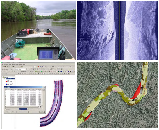
My header image is from Adam J. Kaeser and Thom L. Litts, An Illustrated Guide to Low-cost, Side Scan Sonar Habitat Mapping in Marine and Coastal Fisheries: Dynamics, Management, and Ecosystem Science

What I want to do
Information on benthic substrate is often gathered through methods with fast spatiotemporal decay. One might sample by transect in the summer, then floods & hurricanes change the nature of substrate by winter.
I want to explore using a Side Scan Sonar to map changing substrates over time to track changes in land use/real estate development patterns upstream or possibly find some relationship between dam removal and sediment transport downstream.
I would like to eventually make a lower cost tool. And given that one of my initial sources has already done some tinkering around with side imaging, this may be more than a moonshot.
Why I'm interested
Mapping information tends to stop at a body of water.

Gathering information and data on what is under the water requires high cost or high time costs to gather transects and extrapolate. High resolution data like topobathy & bathymetric lidar is obtained through expensive, time consuming methods--large flight planning crews, flight crews, airplanes, etc.
The work by Kaeser & Litts has been presented & workshopped numerous times since 2010 featuring the need for a remote sensing technique needed for riverscape research in stream systems.
One current project using Side Scan Sonar for substrate mapping is the Chipola River Applied Habitat Benthic Mapping Project in northwest Florida led by Southeast Aquatics Resource Partnership.

The Chipola River Applied Habitat Mapping Project with investigators, Jennifer Bock and Beth Stys, was featured earlier in 2014 in the Fisheries & Information Technology section of the American Fisheries Society as well: Landscape Level In-Stream Habitat Mapping Using Side Scan Sonar.

Low-cost benthic habitat mapping is highly important and cheaper than flying a lidar mission. However, devices for side scan sonar are still in the four-figure range ($2000+).
My attempt and results
I am identifying needs and user scenarios for a lower cost side scan sonar.
I will keep watching for an after market device, troubleshooting guide, or teardown review to make an inventory the components in the device. From there, I can identify potential sellers of the components and see where I can view existing software or papers covering the software used to produce the images.
Questions and next steps
- Read through the Sonar Imagery Geoprocessing Workbook.
- Gather resources, equipment, information, code, etc.
- Gather users & collaborators as there has been mention of a need for repurposing fish sonar.
All images from Adam J. Kaeser and Thom L. Litts, An Illustrated Guide to Low-cost, Side Scan Sonar Habitat Mapping
8 Comments
this is excellent!
Reply to this comment...
Log in to comment
seems like there's some interest, though I don't see any movement, in the AUV crowd: http://www.societyofrobots.com/robotforum/index.php?topic=158.0 http://www.homebuiltrovs.com/rovforum/viewtopic.php?f=16&t=570
Is this a question? Click here to post it to the Questions page.
Reply to this comment...
Log in to comment
The one from Society of Robots right here from 2006. Better than the retail & academic search I started with, I'm impressed you found a forum from 2006. I'm going to cross post this on EnviroDIY.org, maybe in the Commercial Sensors forum, along with some of the AUV crowd's thoughts.
I'll start a note on more use cases, like Side scan sonar in oyster management by Diaz, Cuevas, Buchanan, Gordon, and Perret:
"Information acquired from side scan sonar provides a long-term record, which can be used to detect changes due to environmental catastrophes, vessel groundings and/or harvest pressure."
Is this a question? Click here to post it to the Questions page.
Reply to this comment...
Log in to comment
My search was really quick, the terms I used were "DIY sidescan fish finder." a little deeper digging found that the hummingbird forum has a bunch of DIY "towfish" which are the housing for the hummingbird transducer. While not the actual sonar itself, the housing and tow system are a major part of the design problem. http://forums.sideimagingsoft.com/index.php?board=41.0
Is this a question? Click here to post it to the Questions page.
Reply to this comment...
Log in to comment
I'm in the process of building an autonomous boat and came across this blog. The author is using an Intelliducer from Garmin, which is around $200.00. http://diydrones.com/profiles/blogs/the-ardupilot-controlled-transducer-boat
Reply to this comment...
Log in to comment
You might be interested in an open-source software project I have started for analysis of imagery from the Humminbird low-cost sidescan sonar.
https://github.com/dbuscombe-usgs/PyHum
https://pypi.python.org/pypi/PyHum
Unlike in a GIS, this software is designed to be completely automated. It reads the raw binary files, properly spatially references each beam, carry out radiometric corrections, and texture segmentation. Lots still to do. It is very much work in progress, but please check it out and contribute if you're interested!
Dan
Reply to this comment...
Log in to comment
Todd D Robbins brought this up on the public lab list a few days ago. here's his comment:
I'm not sure if this project has been discussed here previously, but here's an innovative way for measuring the topologies of lake/river beds:
http://letsmakerobots.com/node/21098
Andersen's work has been featured on Hackaday and the Arduino blog:
http://hackaday.com/2015/05/25/project-sea-rendering-autonomously-renders-sea-bottoms/ http://blog.arduino.cc/2015/04/14/lets-make-robots-exploring-lake-depths/
Reply to this comment...
Log in to comment
I have ben conducted a literaturere view of this subject when I encountered this source article, in which I am now responding. The two listed below are quite instructive. MBTElectronics has an embedded link to a free PDF of the studied DIY SSS (Side Scan Sonar) unit.
YES, a DIY SSS unit you can build yourself. This article looks pre-Duino, as it currently is in Rev 1, post initial issue it has a current publishing of 2010, but as an Electronics Archeologist i can honestly assess the original design as pre-Atari. Most of the parts ( Ihavent researched them all) can still be found, and engineering substitutuions are available for anything shown. A duino would EASILY pass for the rolling graph (sooooo Hipster retro, I want one in my refrigerator to tell me how many times I open my fridge for illicit snacking after the dorm ma'am closes down the soup kitchen line.) Anyway..........., the pdf has a fully functioning diy SideScanSonar that ole Doc Edgerton would gladly sit in the middle of the Mystic River with.
http://www.mbtelectronics.com/side-scan-sonar.php Aaaand
http://www.submarineboat.com/scanning_sonar.htm
Reply to this comment...
Log in to comment
Login to comment.