
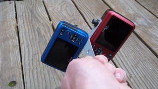
Here's the rig setup I'm attempting to launch. 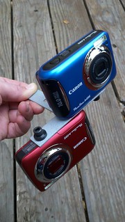
Aspiring balloon mappers - do your research on total setup cost. Helium is expensive.

But I went for it and bought some helium, borrowed the tank through the weekend.
Still doing some prep...laying out the materials..doing research on CHDK. UPDATE CHDK took me a while. Great help on this page http://publiclaboratory.org/notes/warren/3-1-2012/triggering-a495-buttonusb
I was struggling to get into the CHDK < Alt > mode - this doc pushed me over the edge finally http://chdk.wikia.com/wiki/File:CHDK_UserGuide_April_2009_A4.pdf .. since I'm using Mac OS X, I simply used http://www.zenoshrdlu.com/clickpansdm/sdminst.html to load my SD card with the build I downloaded with same authors Acid.app, locked my SD card before inserting back in camera, enter Camera mode, press Playback (you should then see 'Alt') then Menu to see CHDK options.
After many hours of struggling with CHDK - I've learned to use the loader (already linked above)...I've also learned that my Transcend 4GB SDHC cards don't work w/ CHDK for some reason. I had a Toshiba and a SanDisk 2GB micro w/ sd-adapters that DO work...now off to buy new (and bigger) cards.
Bad news: The two places I was thinking of mapping are within 5 miles of our local airport AND right along the primary approach path. 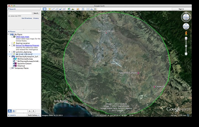
Looking for other vineyards around area...might capture the SLO Marathon on Sunday http://www.slomarathon.com/the-races/marathon I sent out some last minute requests and Ancient Peaks Winery gave me the go-ahead! The balloon took more helium than I expected, still waiting to see how much I actually used - and I unfortunately wasn't able to save any after the 2.5 hour flight.
I learned:
+ Think about building a shield. A couple times my camera lens got close to things.
+ Tweak IR camera. My IR camera seems "too pink".
+ Does IR camera use batteries faster? I put brand new batts in each camera - when I pulled down IR it was powered off for some reason.
+ I was a little early in green-up season for grapes. Shoots were 2-4", small.
6 Comments
Awesome write-up, and great job on the site planning- you really did your homework!
how many cubic feet of helium did you get? $119 is an awefully painful price tag.
Is this a question? Click here to post it to the Questions page.
Reply to this comment...
Log in to comment
Great notes. I think you are OK to fly at low altitude, I would recommend calling the FAA flight service hotline and they can give you official clearance: http://publiclaboratory.org/wiki/mapping-curriculum-regulatory-situation
And as for the $$$helium I source helium nearby in the bay area and the cost has gone up around 60% since I purchased 6 months ago. My supplier seems to think that the price will come back to that level by the end of this year. I want to keep track of what others are seeing and hearing out there.
Reply to this comment...
Log in to comment
Hey JL - Just posted some ideas and tests for a casing for the dual cam rig:
http://publiclaboratory.org/wiki/juice-jug-rig
Reply to this comment...
Log in to comment
Hi Joe - is the map you're working on in MapKnitter the vineyard map? How did that flight go?
https://mapknitter.org/map/view/santa-margarita-ranch-v2-0
I'm really eager to see how folks from vineyards see DIY infrared maps. I think it's an exciting opportunity for grassroots mappers to provide key info to growers, and maybe a chance to earn some $ to pay for our balloon habit :-)
Is this a question? Click here to post it to the Questions page.
Reply to this comment...
Log in to comment
Hey Jeff - that is the map I am working on. I have a lot of work to do still, but I also was trying to get that TMS thing going (thank you and Corey for the progress on that ticket yesterday, by the way!) before I started rectifying.
After my outing, I had some personal issues that kept me from following through on my findings, results and improvements...but things are good now & thanks for lighting the fire beneath me with this comment, to finally do so.
Briefly, I believe that the IR data I captured may not be very useful unfortunately - one of the things I learned is that a lower altitude may be necessary. But also, it was early in the growing season. The grape leaves/buds were quite small. And this was my first time out - I have much to improve upon. I will document my lessons-learned in length, soon - re: CHDK settings, altitude, etc.
Anyway - here are the photos for anyone to see:
Obliques (which the landowner who provided me access wanted): http://sdrv.ms/JVZyeY
Top-down normals: http://sdrv.ms/KwEcpQ
Top-down IR's: http://sdrv.ms/JTERPE
Reply to this comment...
Log in to comment
Wow!!! I don't know -- i see what you mean about the pinkness (what film/filter did you use?) but i think they look pretty good! Do you think there are exposure issues? I think the altitude looks great, though -- what is your concern?
Don't worry, we'll get the TMS thing working. I can try adding a feature to the tms-filter tool soon, and then we have to figure out the zoom-level issues.
Is this a question? Click here to post it to the Questions page.
Reply to this comment...
Log in to comment
Login to comment.