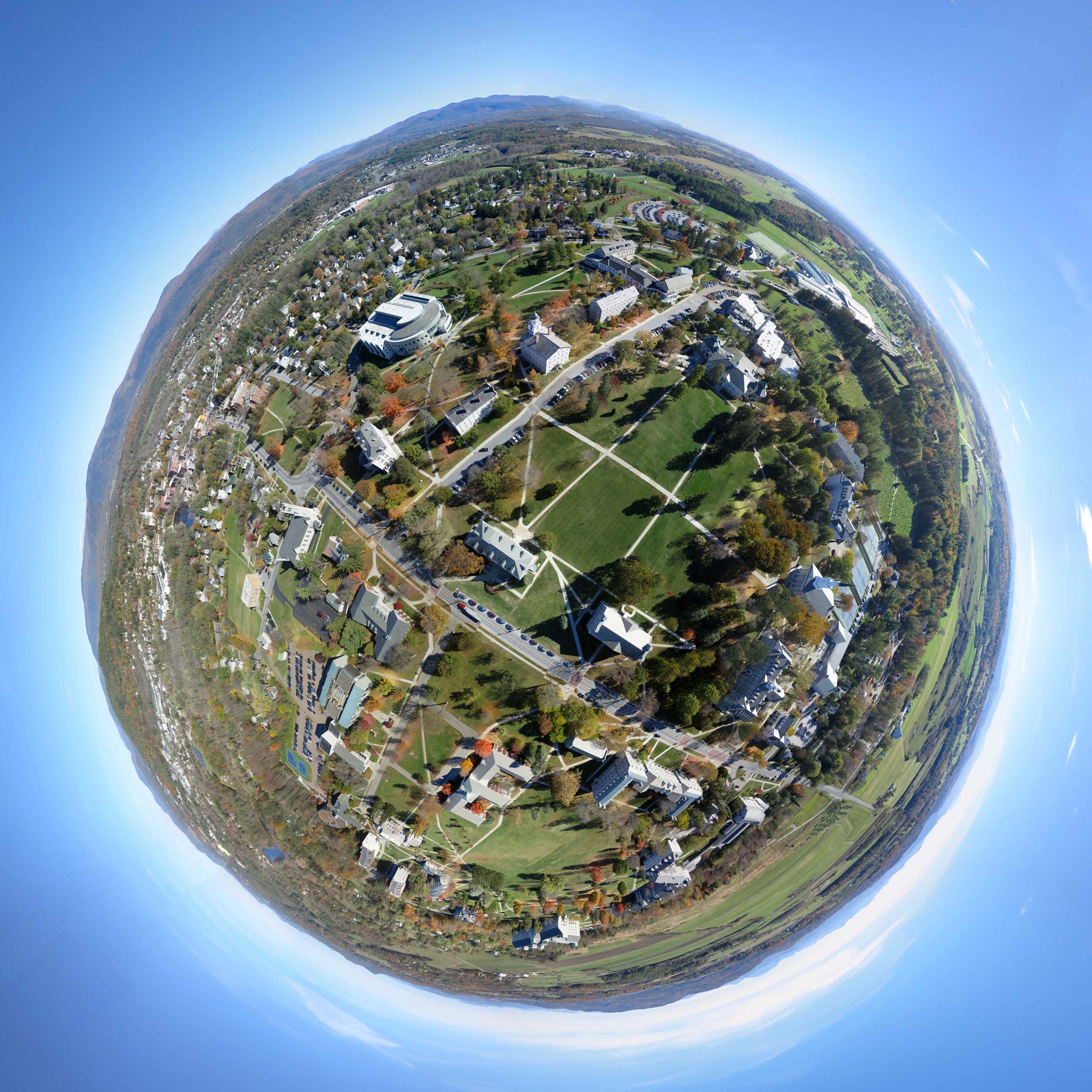
Above: Stereographic projection of a spherical KAP panorama from a few hundred feet above the center of the Middlebury College campus. Stitched from 24 photos.
The only other time I tried to fly a kite on the Middlebury College campus in Vermont there was not enough wind. A 10 mph south wind was forecast yesterday, and that is the best direction for flying in the middle of the campus. There is a mostly treeless quadrangle 500 feet long oriented north-south that can deliver the best views of the iconic academic buildings. It is surrounded by lots of tall trees and five story buildings so there is not much room for error. In fact it's the second most scary place I have ever tried to fly a kite. But there was sun and foliage color in addition to the perfect wind, so I launched $400 worth of gear.

A lot of the leaves have already fallen, so buildings are less hidden from aerial cameras. Mead Memorial Chapel on the main quad, October 19, 2015.
The Fled was in the air continuously between 11:30 AM and 3:00 PM. The first hour there was not enough wind to lift a camera, but that gave me plenty of time to get comfortable with the tight space. The wind slowly picked up all day until it was a real effort to haul in the kite a 2:30. It took me a half an hour to land it.

A Canon S100 on a Saturn V Rig with SkyShield autoKAP controller as it launched for the second session.
As usual, the PowerShot S100 was on the Saturn V Rig capturing 25 photos every 75 seconds in every direction but up. The primary technical difference between this flight and the ones last week was temperature. The previous night was in the 20s (°F) and it did not make it to 40° until afternoon. That turned out to be an important difference. After 65 minutes I pulled down the rig to change the batteries and found that they were already too low to drive the servos correctly. I replaced them, along with the camera battery and SD card, all with spares that were warm in my pockets.

This might be more clothes than I have ever worn to do KAP.
I then sent up the rig for another 65 minutes. During that time I had almost 1000 feet of line out for a while, so I was anticipating good coverage of the campus. When I retrieved the rig I was surprised to see that the servos were suffering from low power again. I later learned that the batteries had lasted for 55 minutes during the first session and only 40 minutes during the second session. I am not sure how to explain the shorter duration in the warmer afternoon. It is possible that the shutter cable and lanyard were restricting the tilt motion and making the servos labor more than necessary (before the camera mostly stopped tilting, sometimes only one or two of the nadir photos got taken). But regardless, less than an hour of operation is not so good. So for cool weather autoKAP, another power supply is called for.
"Above the Quad" at 360cities.net
The above panorama was stitched from 23 photos captured when the rig was a little lower than it was for the little planet panorama in the lead image. Move around in the image. Hold the shift key to use a scroll wheel for zooming. Remove some clutter with a toggle at upper right. Or go full screen.
Today I soldered two battery cases together so I could try the SkyShield with six AAA batteries instead of four. The SkyShield has an LDO voltage regulator that outputs 5 volts but can take inputs of up to 17 volts. Four alkaline AAA batteries are nominally 6 volts, and when their output drops below about 5 volts the servos don't operate correctly. Six AAA batteries provide 9 volts so provide a much greater margin. I was about to go fly the new setup when it got cloudy and still. So I hung it outside my window and turned it on. The six batteries in it are the used ones that would not drive the servos yesterday. So far those batteries have not missed a tilt position in 3.3 hours of continuous operation at 50° F. [Update: I stopped the trial after 5.3 hours of error free operation. That was all I needed to know.] I think I will be flying with six batteries from now on.
Flight notes:
Camera:
- Model: PowerShot S100
- ISO: 80
- Shutter speed: 1/800 second (Tv)
- Focus: manual on infinity
- Focal length: 24mm (eq.)
- White balance: Sunny
- GPS: on
SkyShield:
- Version: 2.4 (3-switch DIP)
- Sketch: version 2.08sfm (beta)
- Mode: Mode 0 (for 24 mm lens, 25 photos/cycle)
- Customization: The nadir tilt angle was changed from 20 to 11 so the camera was pointed straight down.
Flight:
- Kite: Fled
- Wind: From S, 7 rising to 20 mph
- Duration: 3.5 hours
- Photos taken: 1286 (first session), 1418 (second session)
Panorama stitching:
- Software: Microsoft ICE
- Post processing: ICE's "auto complete" feature was used to create extra sky to fill in missing areas in the 360Cities panorama. Panoramas exported from ICE were modified in Photoshop including creating sky to make the 360cities panorama exactly half as high as wide (360Cities requires that for viewing in their spherical viewer).
0 Comments
Login to comment.