What I want to do or know
I'd like to hear advice and find resources that can help us investigate the thermal properties of paved surfaces on a boarding school campus, to inform decisions about materials upgrades in future years.
Background story
A group of students at this high school -- mostly seniors --will be taking on aerial mapping projects on a variety of topics, to gain experience designing, executing, and communicating results of a project.
I have been canvassing the community for ideas about what projects would be useful, and the Director of Facilities had this idea about paved surfaces.
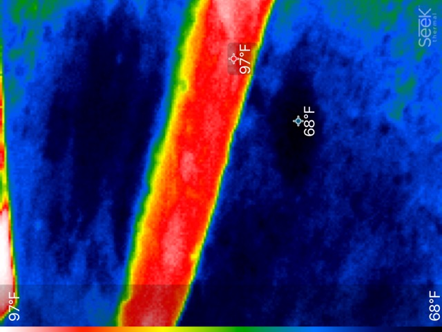
We recently acquired a Seek Thermal Compact XR camera, which plugs into an iPhone (http://www.thermal.com/products/compactxr/). I've attached a test photo taken from a second floor balcony, which shows a paved pathway with lawn on either side, and give the min/max temperatures detected in the image.
I believe that detecting the temperature differences in the evening should be pretty straightforward, if we can solve the problem of how to safely fly the camera (mounting an iphone with fragile attachment), and maintain enough stability to gather clear images.
But I don't know much about how to translate that into more sophisticated concepts such as "urban heat island."
And I would be interested to know of any tips, or warnings about undertaking a project like this.
Many thanks.
Ryan
This is a really intriguing project. The Seek camera makes possible a lot of otherwise very difficult investigations. It should be straightforward to quantify how much hotter roads are compared to lawns. I am not sure what question you hope to ask, so it’s hard to know how to design your study.
Flying the camera is a possibility, but maybe not important enough to expose the equipment to considerable risk. Doing transects on the ground could provide plenty of data to quantify the dramatic differences in temperature between different surfaces. Existing maps of the campus could then be used to determine the area of each type of surface present.
Flying the camera involves expense and a level of risk that will depend on your experience and the proximity of trees, overhead lines, and buildings. The choice among helium balloons, kites, or drones will depend on all of these things. Using a long pole could be a good compromise between risk and ground coverage.
The temperature of a ground surface is a function of several things and can change rapidly. Your measurements will have to control for these variables.
If your observation protocol is likely to provide different answers on different days, you will have to repeat it on multiple days.
To quantify how your campus is contributing to a heat island, you could establish a control area with no (or with fewer) roads and buildings. Similar measurements in both areas could be compared.
Measuring temperature does not tell you much about how much “heat” there is. You also have to know how much mass is at each temperature. That is a much more complicated modeling exercise. It can be simplified by determining how much ground area is at each temperature, but a hectare of parking lot and a hectare of three-story building at the same temperature will emit heat to the environment differently because the building has more mass, more surface area, and may be generating its own heat.
There should be plenty for your students to think about.
Chris
Thank you so much, Chris! Indeed, lots to think about. Will let you know what sort of first steps we come up with, and where it goes from there.
Reply to this comment...
Log in to comment