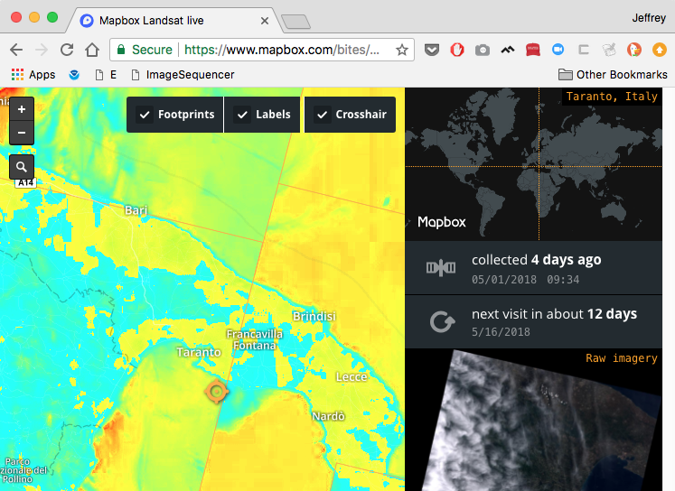
I've been working with the new Image Sequencer, a Public Lab project, to try see how it works as a "filter" for map tiles on another site. Working with Mapbox's Landsat Live site, which shows the most recent Landsat satellite images for anywhere on the earth, I created a browser bookmarklet which accepts an Image Sequencer "command string" and runs it on all the tiles currently shown.
This is a great use case for Image Sequencer, a project I've been working on with @ccpandhare and @tech4gt, which is supported in part by NASA's AREN project and by Google Summer of Code.
When you click the bookmarklet, you're prompted for a command string:

It's a little slow, but I ran the NDVI equation with the command ndvi,colormap (inappropriately, since the imagery shown is just RGB, not infrared, but just as a test) and you can see the results in the lead image and in this video:
Some caveats:
- it needs some tweaking to "detect" the right layer of tiles to apply to, or it'll apply to the labeling layers too
- it needs CORS permissions set on the tile server or JavaScript will be denied access to modify the images
- we haven't yet allowed setting options via the string syntax, but will in this issue and that'll allow things like choosing different color maps
- we're working on doing the processing on another thread here
- we could to run the tile processing sequentially because it'd look cool... boop boop boop boop! (the sound of each tile getting converted)
I'm reaching out to MapBox to see if they have infrared bands available, so we can do true NDVI! Any help appreciated!
MapKnitter
This is the same kind of filtering we're now enabling in MapKnitter; update on that coming soon:

7 Comments
@ccpandhare @tech4gt exciting!
@jbreen - you'd know this... are there any tiles available for LANDSAT's near-infrared bands? Especially like NGB type tiles where infrared is in the red channel and visible in the blue? I always ask you these kinds of questions like you're a GIS Gandalf, but it's because you always know!!!
Is this a question? Click here to post it to the Questions page.
Reply to this comment...
Log in to comment
@wward1400 @adam-griffith @MicheleTobias @lprashad @eustatic @nedhorning @cfastie you might like this little experiment too!
Reply to this comment...
Log in to comment
@warren I think you may have stumped me. Have you looked at GloVis? glovis.usgs.gov
Is this a question? Click here to post it to the Questions page.
Reply to this comment...
Log in to comment
@warren wow this looks very promising!! :-D
Reply to this comment...
Log in to comment
hunh, can you do this with MODIS?
Is this a question? Click here to post it to the Questions page.
Reply to this comment...
Log in to comment
Probably! Can you point me at a MODIS source with bands youre interested in?
Is this a question? Click here to post it to the Questions page.
Reply to this comment...
Log in to comment
@jywarren this is awesome!!! :D
Reply to this comment...
Log in to comment
Login to comment.