Passenger Pigeon
This is a revision from November 04, 2017 13:40.
View all revisions
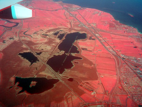
Passenger Pigeon is a project/concept for collecting aerial imagery from passenger plane windows with handheld digital cameras. To make a map, just take photos out the window of your commercial flight. Then use the free and open source MapKnitter.org to align the images with a map as soon as you land.
Examples (click links for TMS/Geotiff downloads)
- Utah (shown below): http://publiclab.org/notes/eustatic/5-10-2012/hills-have-acne-passenger-pigeon-photos-drill-sites-out-west
- Manhattan/Brooklyn: https://mapknitter.org/map/view/newtown-creek-docsearls
Tips for photographers
- point the camera as straight downwards as possible
- hold the camera as stably as you can - brace it against the window
- try not to sit behind the wing, where the engine exhaust blurs the air
- take note of where the photos are, if you anticipate difficulty in placing them on a map later
- check flight-tracking websites ahead of time to plan when you'll be able to take good photos (possibly during landing or takeoff, if you're allowed to use your camera)
Questions
| Title | Author | Updated | Likes | Comments |
|---|---|---|---|---|
| Nothing yet on the topic "passenger-pigeon" -- be the first to post something! |
Activities
| Purpose | Category | Status | Author | Time | Difficulty | Replications |
|---|---|---|---|---|---|---|
| Infragram test photos from a plane window | - | - | @warren | - | - | 0 replications: Try it » |
| Flightstats.com for Passenger Pigeon | - | - | @mathew | - | - | 0 replications: Try it » |
| Passenger Pigeon methods: getting your location, the hacky way | - | - | @eustatic | - | - | 0 replications: Try it » |
Activities should include a materials list, costs and a step-by-step guide to construction with photos. Learn what makes a good activity here.
Maps
Advanced
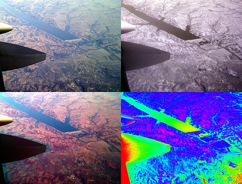
Some Public Lab folks have done multispectral imaging from a plane window -- see the near-infrared camera page for details on how to collect/produce infrared imagery with less than $150 of equipment.