|
11
CURRENT
|
liz |
June 10, 2013 18:27
| almost 11 years ago
It's easy to add your MapKnitter exported map as a background layer when editing OpenStreetMap. This wiki page explains how to connect to Potlatch 2 and iD editor. This slide show from State of the Map US 2013 may help illustrates these workflows: http://www.slideshare.net/LizBarry/2013-0609-sotmussf
There is also a case study of an earlier method at the bottom of this wiki page.

Potlatch 2
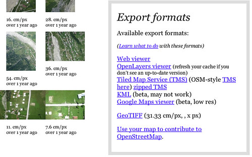
With help from Andreas Trawoeger from the OSM-talk list, we set up a "deep link" underneath the Export formats area, so you can open your map directly in OpenStreetMap's Potlatch 2 editor by clicking "Use your map to contribute to OpenStreetMap in Potlatch":
Note: this is only available for maps which have been released under open licenses, such as CC-BY or public domain.
iD Editor
In Mapknitter.org, there is a "deep link" underneath the Export formats area so you can click "Use your map to contribute to OpenStreetMap in iD". This will open the iD editor hosted on openstreetmap.us.
Manual method for adding a TMS layer on openstreetmap.org: you can click the Edit tab, choose the iD editor, then click the background tab to add a custom layer. The URL you paste in will be formatted like this: https://mapknitter.org/tms/2011-7-31-brooklyn-gowanus-vis/alt/{z}/{x}/{y}.png


Old technique (no longer necessary)
In this example I'm using a map of Mestia, a city in the Svaneti region of Georgia.
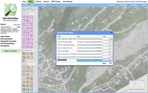
First, open the "backgrounds" menu and choose "Add":
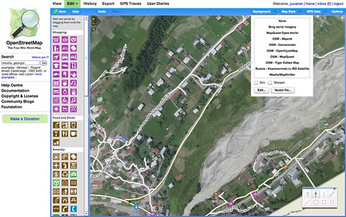
Then, add a new background layer, using your map's "OSM-style TMS" link, with added z,x,y like this:
https://mapknitter.org/tms/mestia/alt/$z/$x/$y.png
Where "mestia" is your map's name. See screenshot:
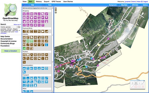
You can turn off "dimming" to see the map more clearly:
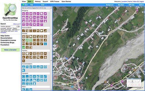
Zoom in and see how well your balloon map fits existing data. Then trace to add more features:
|
Revert |
|
|
10
|
liz |
June 08, 2013 19:29
| almost 11 years ago
It's easy to add your MapKnitter exported map as a background layer when editing OpenStreetMap. This wiki page explains how to connect to Potlatch 2 and iD editor. There is also a case study of an earlier method at bottom.
Potlatch 2
With help from Andreas Trawoeger from the OSM-talk list, we set up a "deep link" underneath the Export formats area, so you can open your map directly in OpenStreetMap's Potlatch 2 editor by clicking "Use your map to contribute to OpenStreetMap in Potlatch":
Note: this is only available for maps which have been released under open licenses, such as CC-BY or public domain.
iD Editor
In Mapknitter.org, there is a "deep link" underneath the Export formats area so you can click "Use your map to contribute to OpenStreetMap in iD". This will open the iD editor hosted on openstreetmap.us.
Manual method for adding a TMS layer on openstreetmap.org: you can click the Edit tab, choose the iD editor, then click the background tab to add a custom layer. The URL you paste in will be formatted like this: https://mapknitter.org/tms/2011-7-31-brooklyn-gowanus-vis/alt/{z}/{x}/{y}.png
Old technique (no longer necessary)
In this example I'm using a map of Mestia, a city in the Svaneti region of Georgia.
First, open the "backgrounds" menu and choose "Add":
Then, add a new background layer, using your map's "OSM-style TMS" link, with added z,x,y like this:
https://mapknitter.org/tms/mestia/alt/$z/$x/$y.png
Where "mestia" is your map's name. See screenshot:
You can turn off "dimming" to see the map more clearly:
Zoom in and see how well your balloon map fits existing data. Then trace to add more features:
|
Revert |
|
|
9
|
liz |
June 08, 2013 19:27
| almost 11 years ago
It's easy to add your MapKnitter exported map as a background layer when editing OpenStreetMap. This wiki page explains how to connect to Potlatch 2 and iD editor. There is also a case study of an earlier method at bottom.
Potlatch 2
With help from Andreas Trawoeger from the OSM-talk list, we set up a "deep link" underneath the Export formats area, so you can open your map directly in OpenStreetMap's Potlatch 2 editor by clicking "Use your map to contribute to OpenStreetMap in Potlatch":
Note: this is only available for maps which have been released under open licenses, such as CC-BY or public domain.
iD Editor
In Mapknitter.org, there is a "deep link" underneath the Export formats area so you can open your map directly in OpenStreetMap's iD editor editor by clicking "Use your map to contribute to OpenStreetMap in iD". This will open the iD editor hosted on openstreetmap.us.
If you want to use openstreetmap.org, you can click the Edit tab, choose the iD editor, then click the background tab to add a custom layer. The URL you paste in will be formatted like this: https://mapknitter.org/tms/2011-7-31-brooklyn-gowanus-vis/alt/{z}/{x}/{y}.png
Old technique (no longer necessary)
In this example I'm using a map of Mestia, a city in the Svaneti region of Georgia.
First, open the "backgrounds" menu and choose "Add":
Then, add a new background layer, using your map's "OSM-style TMS" link, with added z,x,y like this:
https://mapknitter.org/tms/mestia/alt/$z/$x/$y.png
Where "mestia" is your map's name. See screenshot:
You can turn off "dimming" to see the map more clearly:
Zoom in and see how well your balloon map fits existing data. Then trace to add more features:
|
Revert |
|
|
8
|
liz |
June 08, 2013 00:23
| almost 11 years ago
It's easy to add your MapKnitter exported map as a background layer when editing OpenStreetMap in Potlatch 2. In this example I'm using a map of Mestia, a city in the Svaneti region of Georgia.
Potlatch 2
With help from Andreas Trawoeger from the OSM-talk list, we set up a "deep link" so that simply by clicking Use your map to contribute to OpenStreetMap underneath the Export formats area, you can open your map directly in OpenStreetMap's Potlatch 2 editor by clicking "Use your map to contribute to OpenStreetMap":
Note: this only works for maps which have been released under open licenses, such as CC-BY or public domain.
iD Editor
By clicking the Edit tab on openstreetmap.org, you can choose the iD editor, then click the background tab to add a custom layer. The URL you paste in will be formatted like this: https://mapknitter.org/tms/2011-7-31-brooklyn-gowanus-vis/alt/{z}/{x}/{y}.png
Also, you can use the openstreetmap.us installation of iD editor, and provide a URL similar to the one below:
http://openstreetmap.us/iD/release/#background=custom:https://mapknitter.org/tms/2011-7-31-brooklyn-gowanus-vis/alt/{z}/{x}/{y}.png&map=16.56/-73.98934/40.67737
Old technique (no longer necessary)
First, open the "backgrounds" menu and choose "Add":
Then, add a new background layer, using your map's "OSM-style TMS" link, with added z,x,y like this:
https://mapknitter.org/tms/mestia/alt/$z/$x/$y.png
Where "mestia" is your map's name. See screenshot:
You can turn off "dimming" to see the map more clearly:
Zoom in and see how well your balloon map fits existing data. Then trace to add more features:
|
Revert |
|
|
7
|
liz |
June 07, 2013 23:50
| almost 11 years ago
It's easy to add your MapKnitter exported map as a background layer when editing OpenStreetMap in Potlatch 2. In this example I'm using a map of Mestia, a city in the Svaneti region of Georgia.
New technique
With help from Andreas Trawoeger from the OSM-talk list, we set up a "deep link" so that simply by clicking Use your map to contribute to OpenStreetMap underneath the Export formats area, you can open your map directly in OpenStreetMap's Potlatch 2 editor by clicking "Use your map to contribute to OpenStreetMap":
Note: this only works for maps which have been released under open licenses, such as CC-BY or public domain.
Old technique (no longer necessary)
First, open the "backgrounds" menu and choose "Add":
Then, add a new background layer, using your map's "OSM-style TMS" link, with added z,x,y like this:
https://mapknitter.org/tms/mestia/alt/$z/$x/$y.png
Where "mestia" is your map's name. See screenshot:
You can turn off "dimming" to see the map more clearly:
Zoom in and see how well your balloon map fits existing data. Then trace to add more features:
|
Revert |
|
|
6
|
liz |
June 07, 2013 23:47
| almost 11 years ago
It's easy to add your MapKnitter exported map as a background layer when editing OpenStreetMap in Potlatch 2. In this example I'm using a map of Mestia, a city in the Svaneti region of Georgia.
New technique
With help from Andreas Trawoeger from the OSM-talk list, we set up a "deep link" so that simply by clicking Use your map to contribute to OpenStreetMap underneath the Export formats area, you can open your map directly in OpenStreetMap's Potlatch 2 editor by clicking "Use your map to contribute to OpenStreetMap":
Note: this only works for maps which have been released under open licenses, such as CC-BY or public domain.
Old technique (no longer necessary)
First, open the "backgrounds" menu and choose "Add":
Then, add a new background layer, using your map's "OSM-style TMS" link, with added z,x,y like this:
https://mapknitter.org/tms/mestia/alt/$z/$x/$y.png
Where "mestia" is your map's name. See screenshot:
You can turn off "dimming" to see the map more clearly:
Zoom in and see how well your balloon map fits existing data. Then trace to add more features:
|
Revert |
|
|
5
|
warren |
March 13, 2012 22:04
| about 12 years ago
It's easy to add your MapKnitter exported map as a background layer when editing OpenStreetMap in Potlatch 2. In this example I'm using a map of Mestia, a city in the Svaneti region of Georgia.
New technique
With help from Andreas Trawoeger from the OSM-talk list, we set up a "deep link" so that simply by clicking Use your map to contribute to OpenStreetMap underneath the Export formats area, you can open your map directly in OpenStreetMap's Potlatch 2 editor:
Note: this only works for maps which have been released under open licenses, such as CC-BY or public domain.
Old technique (no longer necessary)
First, open the "backgrounds" menu and choose "Add":
Then, add a new background layer, using your map's "OSM-style TMS" link, with added z,x,y like this:
https://mapknitter.org/tms/mestia/alt/$z/$x/$y.png
Where "mestia" is your map's name. See screenshot:
You can turn off "dimming" to see the map more clearly:
Zoom in and see how well your balloon map fits existing data. Then trace to add more features:
|
Revert |
|
|
4
|
warren |
March 13, 2012 22:04
| about 12 years ago
It's easy to add your MapKnitter exported map as a background layer when editing OpenStreetMap in Potlatch 2. In this example I'm using a map of Mestia, a city in the Svaneti region of Georgia.
New technique
With help from Andreas Trawoeger from the OSM-talk list, we set up a "deep link" so that simply by clicking Use your map to contribute to OpenStreetMap underneath the Export formats area, you can open your map directly in OpenStreetMap's Potlatch 2 editor:
Note: this only works for maps which have been released under open licenses, such as CC-BY or public domain.
Old technique (no longer necessary)
First, open the "backgrounds" menu and choose "Add":
Then, add a new background layer, using your map's "OSM-style TMS" link, with added z,x,y like this:
https://mapknitter.org/tms/mestia/alt/$z/$x/$y.png
Where "mestia" is your map's name. See screenshot:
You can turn off "dimming" to see the map more clearly:
Zoom in and see how well your balloon map fits existing data. Then trace to add more features:
|
Revert |
|
|
3
|
warren |
March 13, 2012 22:03
| about 12 years ago
It's easy to add your MapKnitter exported map as a background layer when editing OpenStreetMap in Potlatch 2. In this example I'm using a map of Mestia, a city in the Svaneti region of Georgia.
New technique
With help from Andreas Trawoeger from the OSM-talk list, we set up a "deep link" so that simply by clicking Use your map to contribute to OpenStreetMap underneath the Export formats area, you can open your map directly in OpenStreetMap's Potlatch 2 editor:
Note: this only works for maps which have been released under open licenses, such as CC-BY or public domain.
Old technique (no longer necessary)
First, open the "backgrounds" menu and choose "Add":
Then, add a new background layer, using your map's "OSM-style TMS" link, with added z,x,y like this:
https://mapknitter.org/tms/mestia/alt/$z/$x/$y.png
Where "mestia" is your map's name. See screenshot:
You can turn off "dimming" to see the map more clearly:
Zoom in and see how well your balloon map fits existing data. Then trace to add more features:
|
Revert |
|
|
2
|
warren |
March 09, 2012 15:12
| about 12 years ago
It's easy to add your MapKnitter exported map as a background layer when editing OpenStreetMap in Potlatch 2. In this example I'm using a map of Mestia, a city in the Svaneti region of Georgia.
First, open the "backgrounds" menu and choose "Add":
Then, add a new background layer, using your map's "OSM-style TMS" link, with added z,x,y like this:
https://mapknitter.org/tms/mestia/alt/$z/$x/$y.png
Where "mestia" is your map's name. See screenshot:
You can turn off "dimming" to see the map more clearly:
Zoom in and see how well your balloon map fits existing data. Then trace to add more features:
|
Revert |
|
|
1
|
warren |
March 09, 2012 14:54
| about 12 years ago
It's easy to add your MapKnitter exported map as a background layer when editing OpenStreetMap in Potlatch 2.
First, open the "backgrounds" menu and choose "Add":
Then, add a new background layer, using your map's "OSM-style TMS" link, with added z,x,y like this:
https://mapknitter.org/tms/mestia/alt/$z/$x/$y.png
Where "mestia" is your map's name. See screenshot:
You can turn off "dimming" to see the map more clearly:
Zoom in and see how well your balloon map fits existing data. Then trace to add more features:
|
Revert |
|
|
0
|
warren |
March 09, 2012 14:52
| about 12 years ago
It's easy to add your MapKnitter exported map as a background layer when editing OpenStreetMap in Potlatch 2.
First, open the "backgrounds" menu and choose "Add":
https://www.flickr.com/photos/jeffreywarren/6966926691/in/photostream/
Then, add a new background layer, using your map's "OSM-style TMS" link, with added z,x,y like this:
https://mapknitter.org/tms/mestia/alt/$z/$x/$y.png
Where "mestia" is your map's name. See screenshot:
You can turn off "dimming" to see the map more clearly:
Zoom in and see how well your balloon map fits existing data. Then trace to add more features:
|
Revert |
|