Public Lab respectfully draws on multiple rich lineages of organizing with a site-specific focus for community self-determination.
>_We lift up indigenous movements for land defense, poor people's struggles for land reform / tenure, the lived expertise of HIV patients that changed medical research, and Public Lab's own predecessor organization Grassroots Mapping as ancestors in this work. We lift up the methods and ethics of Freirian organizing, action research, participatory planning, and public participation geographic information systems (PPGIS) as we develop methods and ethics._
**Public Lab's community science projects are place-based and led by local residents**. This is for several reasons, including: 1) people near the site through time have priceless lived experience; 2) governance is geographic by what environmental regulations are in effect and which electoral district you're a constituent in; and 3) place offers a container for multiple standpoints to offer views on the same place. **Stand for what you stand on!**
This page is a place to collect and organize resources on organizing. Visit the [organizing tag page](https://publiclab.org/tag/organizing) to see the latest community posts about organizing on Public Lab, and get updates on this topic by following:
Follow Organizing
On this page you can:
Learn about different methods for community organizing, including tactics for place-based organizing and organizing-related activities
Join the conversation
- Ask a question, answer a question, or follow future questions on organizing
- Post an issue brief that describes your local place-based concern
Read stories from organizers doing community science
Find further reading and resources on organizing
# Methods for community organizing
## Tactics for place-based organizing
We recommend this sequence of steps, even if you skip a few, for attracting and organizing a group of people around place-based research.
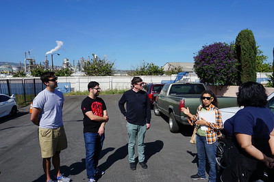
### Tour the area
Move through the area together
+ [How to organize walking tours](https://www.canr.msu.edu/news/how-to-organize-walking-tours) from the School of Planning, Design and Construction at Michigan State University
+ [Benefits of a community bus tour](https://www.canr.msu.edu/news/benefits-of-a-community-bus-tour)
+ [How to make a Green Map cycling tour](https://www.youtube.com/watch?v=Wb-O-es1bkI) video (and [in Chinese here](https://www.youtube.com/watch?v=yVC3nAER0lk))
 _Image: [Emmett Institute at UCLA School of Law](https://www.flickr.com/photos/156678922@N05/47595310591), [CC BY NC](https://creativecommons.org/licenses/by-nc/2.0/)_
### Mental mapping
Invite each person to draw a mental map of landmarks, personal situated memories, infrastructure
+ [Host a collaborative map drawing workshop](https://publiclab.org/notes/liz/04-05-2017/host-an-event-to-draw-a-picture-of-your-place-as-a-group)

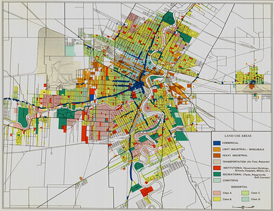
### Historical land use mapping
Start investigating what's happened previously on this site as the best way to focus future study designs
+ [How to find out past and current uses for an area of land](https://publiclab.org/notes/bhamster/02-19-2021/how-to-find-out-past-and-current-uses-for-an-area-of-land)
 _Image: [Manitoba Historical Maps](https://www.flickr.com/photos/11496488@N07/2235371897), [CC BY](https://creativecommons.org/licenses/by/2.0/)_
### Aerial mapping
Capture a portrait of the landscape with you and the group in it. Bonus, this is really fun!
+ [How to decide on a tool for mapping](https://publiclab.org/notes/stevie/04-26-2019/how-to-decide-on-a-tool-for-mapping)
+ [Host a balloon mapping workshop](https://publiclab.org/notes/liz/03-15-2017/host-a-balloon-mapping-workshop)

### Annotating aerial maps
Add the points that emerged from touring the site, drawing mental maps, and overlaying the historical maps
+ [How to make your own community annotated map!](https://publiclab.org/notes/julia_e_masters/06-09-2021/how-to-make-your-own-community-annotated-map)
+ [Grassroots Mapping in Butte Goes Analog](https://publiclab.org/notes/mathew/12-13-2011/grassroots-mapping-butte-goes-analog)
 _Image: by @eustatic_
Now you've got a base upon which to explain how you see the environment to others and invite them to "see alongside" as well.
This content will likely elicit the next round of questioning, which will provide some direction for your group to:
+ Design future studies. See https://publiclab.org/wiki/study-design.
+ Taking action with your maps: see how you can use your maps for advocacy [LINK to come]
## More methods for organizing
+ [How to facilitate a meeting](https://publiclab.org/wiki/facilitation)
+ [Host a community organizing event ](https://publiclab.org/wiki/host-an-event#1.+Community+organizing+events)
+ [How to host a barnraising](https://publiclab.org/wiki/barnraising-host)
+ How to make a power map: LINK to come
Methods published on Public Lab and tagged with `organizing` will appear on the organizing methods page at https://publiclab.org/methods#organizing
## Activities
Activities on Public Lab that have been tagged with `activity:organizing` will appear here
[activities:organizing]
## Join the conversation
### Questions from the community
+ See if other community members are asking questions like yours
+ Ask a question so other community members can offer support
+ Sign up below to be notified when someone asks an organizing-related question
Questions tagged with `question:organizing` will appear here
[questions:organizing]
### Post an Issue Brief
Share information about a local environmental health concern and get support from the Public Lab community by writing and posting an Issue Brief. Visit “[Write an Issue Brief](https://publiclab.org/wiki/issue-brief)” to find information on what an issue brief is, see examples, and learn how to write one.
## Stories from community organizers
+ [Stories from the Public Lab community](https://publiclab.org/wiki/stories)
+ [Community Science and Monitoring Networks in Central California](https://publiclab.org/notes/amocorro/03-11-2021/community-science-and-monitoring-networks-in-central-california)
+ [What fuels a movement?](https://publiclab.org/notes/stevie/12-01-2016/what-fuels-a-movement)
## Further reading and resources
+ [Tools for equitable climate resilience--Fostering community-led research and knowledge](http://www.rivernetwork.org/wp-content/uploads/2021/02/rivernetworkcommunityledresearchtoolkit.pdf): a comprehensive toolkit from [River Network](http://rivernetwork.org/) on how to organize and facilitate community-led research. Also includes information about community mapping (pg. 13) and case studies.
+ [Mapping for Community Organizing](https://hc-v6-static.s3.amazonaws.com/media/resources/tmp/Community_Organizing.pdf): From the [Advancement Project](http://www.advancementprojectca.orgh/), this guide explains how maps can be used in community organizing, especially when planning a campaign.
Join us for a training on the Sand Sentinel Program!
Have you seen sand blowing off a frac sand pile? A stream cloudy with sediment coming off a mine? These are potential permit violations that need to be reported. The Sand Sentinel program was created to make identifying and filing suspected permit violations easier to do.
Reporting environmental concerns when you see them is an important part of the accountability process for any industry. Permits are required for operating any industry including frac sand mines. They are in effect both when the industry is operating, and when they are closed. However, permit violations often go unchecked if no one reports them. Learning how to identify potential permit violations will help our communities to ensure pollution events are caught and dealt with!
##Join us for an online training on the The Sand Sentinel program on Thursday, February 18, at 1pm CT.
At this training you will:
- Learn how to identify observable permit violations of the frac sand mining industry,
- Practice gathering the information required for reporting,
- Identify where permit violations can be reported to, and
- Learn about the value in logging nuisance observations.
###Where:
Online, the link to the event will be sent to those who register ahead of time
###When:
Wednesday February 18, 1pm to 3pm CT
###Who should join:
Anyone with interest in reporting observable environmental permit violations, specifically those in Wisconsin in regards to the fracing industry.
###Registration
**Register by February 8 to ensure there's enough time for us to mail you the training packet!** Please include an address we can ship the training materials to in your registration.
_Sponsored by Frac Sand Sentinel: Project Outreach and Public Lab Informational Materials will be available._ 

 _Image: by @eustatic_