The Public Laboratory for Open Technology and Science (PLOTS) collaboratively develops and publicizes accessible technologies for investigating and reporting on local environmental health and justice issues. PLOTS provides an online research space for citizens, linking them to scientists, social scientists, and technologists. PLOTS is an expansion of Grassroots Mapping, where citizens use helium-filled balloons and digital cameras to generate high resolution “satellite” maps. Using these tools, scores of independent citizens generated some of the highest quality map data of the Deepwater Horizon oil spill. By releasing the data into the public domain to ensure open access, we made it possible for organizations such as CNN, the New York Times, the Boston Globe, and even Google Maps to republish our data during the BP media blackout. PLOTS builds on this success to generate a tool kit and online community for citizen-based, grassroots environmental and public health data gathering and research.
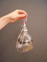
PLOTS asks: How can we diversify, support, sustain and aggregate community-led information gathering to transform the way local geographic communities investigate environmental issues? PLOTS answers: we work in collaboration with local groups to generate citizen science tools that are responsive and adaptable to local needs and constraints. We are already developing and testing new DIY tools. Our first set includes a thermal imaging camera for detecting heat leaks from buildings for only $200 (compared to a typical $5,000 for an off-the-shelf version), a toxin hunting tool adapted from the Roomba vacuum cleaner, and an inexpensive portable spectrometer for analyzing environmental contaminants adapted from a digital camera.
Our tools are already being published and shared online, as well as in face-to-face workshops in communities we are working with along the Gulf Coast, in West Virginia, Wisconsin, New York, and Colorado. A more structured online space, however, will allow us to scale up our outreach and documentation efforts and generate communication and collaboration between regional groups. Communities will be able to analyze and visualize their data, publish their results, and share new techniques. Many of our tools already include an online component -- for example, users of our spectrometry tool upload their spectrometer data to an online analysis site, now under development. All our tools and analysis software are open source -- as is the data we publish. Beyond building research and communication within grassroots communities, our web portal will offer easy and comprehensive access to citizen-sourced data for local and national news agencies, many of whom republished our oil spill imagery in the absence of similar quality imagery from traditional sources.
PLOTS’ core research team combines expertise in digital media, programming, anthropology, citizen science, biology, geology, geography, art and design. Our interdisciplinary group integrates lay and expert initiatives in social and scientific fields into lasting research and data gathering collaborations. Communities affected by the problems of climate change, contamination, environmental justice, and corporate responsibility are often key innovators in solving these problems; PLOTS empowers hyperlocal, community-led efforts with DIY research tools, online data collection and analysis.