 Good example in GDAL/Python: http://www.gis.usu.edu/~chrisg/python/2009/lectures/ospy_slides5.pdf
Script for GDAL: http://www.jeremymsmith.us/davidson/NDVI.py
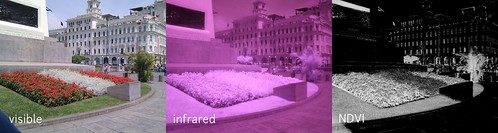
Remember, NDVI is:
*Infrared - Visible / Infrared + Visible*
##GDAL commands##
Splice out a single band and save as independent geotiff:
Good example in GDAL/Python: http://www.gis.usu.edu/~chrisg/python/2009/lectures/ospy_slides5.pdf
Script for GDAL: http://www.jeremymsmith.us/davidson/NDVI.py
Remember, NDVI is:
*Infrared - Visible / Infrared + Visible*
##GDAL commands##
Splice out a single band and save as independent geotiff:
gdal_translate -of GTiff -b 2 morflex-freeflight-geo.tif morflex-freeflight-green.tif
On using NDVI.py, I got this error:
nautilus-2:morflex-lima-freeflight warren$ python NDVI.py
Traceback (most recent call last):
  File "NDVI.py", line 31, in
    var1 = subtract(band4, band3)
ValueError: shape mismatch: objects cannot be broadcast to a single shape
Perhaps we can use this GDAL crop script to make both images the same shape: http://www.enricozini.org/2010/tips/gdal-crop/