*As part of the [Grassroots Mapping Curriculum](/wiki/mapping-curriculum) series.*
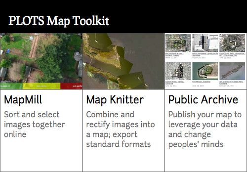 1) MapMill
[About MapMill](/wiki/mapmill)
2) MapKnitter map project creation
[About MapKnitter](/wiki/mapknitter)
3) Map making with Knitter, adding local images, mapmill images
4) Export
5) Publish in the Public Laboratory archive.
- "Want to make a point with your map? Change peoples' minds, challenge the public's attitude about a place? Contact PLOTS staff to have your map featured in the PLOTS Archive."
##PLOTS Map Toolkit 1.0##
Release date: Sept 30
[MapKnitter at GitHub](github.com/jywarren/mapknitter/issues)
##PLOTS Map Toolkit 2.0##
Release date? 2012
* x/y coordinate notes inside of maps
* smartphone app?
1) MapMill
[About MapMill](/wiki/mapmill)
2) MapKnitter map project creation
[About MapKnitter](/wiki/mapknitter)
3) Map making with Knitter, adding local images, mapmill images
4) Export
5) Publish in the Public Laboratory archive.
- "Want to make a point with your map? Change peoples' minds, challenge the public's attitude about a place? Contact PLOTS staff to have your map featured in the PLOTS Archive."
##PLOTS Map Toolkit 1.0##
Release date: Sept 30
[MapKnitter at GitHub](github.com/jywarren/mapknitter/issues)
##PLOTS Map Toolkit 2.0##
Release date? 2012
* x/y coordinate notes inside of maps
* smartphone app?
Mapmill.org
currently in development:
wish list: https://github.com/jywarren/mapmill/issues
- exif data
- sort by time, sort by rank
-connection to /raw datasets for each map in the archive, upload once and done.
Knitter
currently in development: masking
wish list: https://github.com/jywarren/cartagen/issues
- rotate only, apart from rescale only
- activity notification (split second feedback, letting user know to wait for tool to complete current task)
Archive
currently in development:
wish list: connection to knitter, but how? export to archive?