by Phil Silva and Liz Barry
Published originally in 2013 Grassroots Mapping Forum #4.
Order a copy or subscribe online. Only $15/year!
It probably comes as no surprise to read that good things are happening in the hundreds of community gardens throughout NYC and beyond. From growing fresh veggies to composting kitchen scraps to providing city dwellers with beautiful public spaces, these gardens do lot of heavy lifting with little help from city government. But just how much of an impact are these gardens having on quality of life in the city? How do gardeners know if they’ve succeeded in changing their little corner of the urban environment?
Over the summer, gardeners across the city set out to measure some of the outcomes of their work with help from Five Borough Farm, an initiative aimed at supporting urban agriculture in New York. Public Lab co-founder Liz Barry, along with longtime collaborator Philip Silva, worked with gardeners to develop a toolkit of methods for measuring the impacts of an eclectic mix of activities. We began with a daylong workshop giving gardeners a chance to craft their own approaches to collecting data on the impacts of their work.

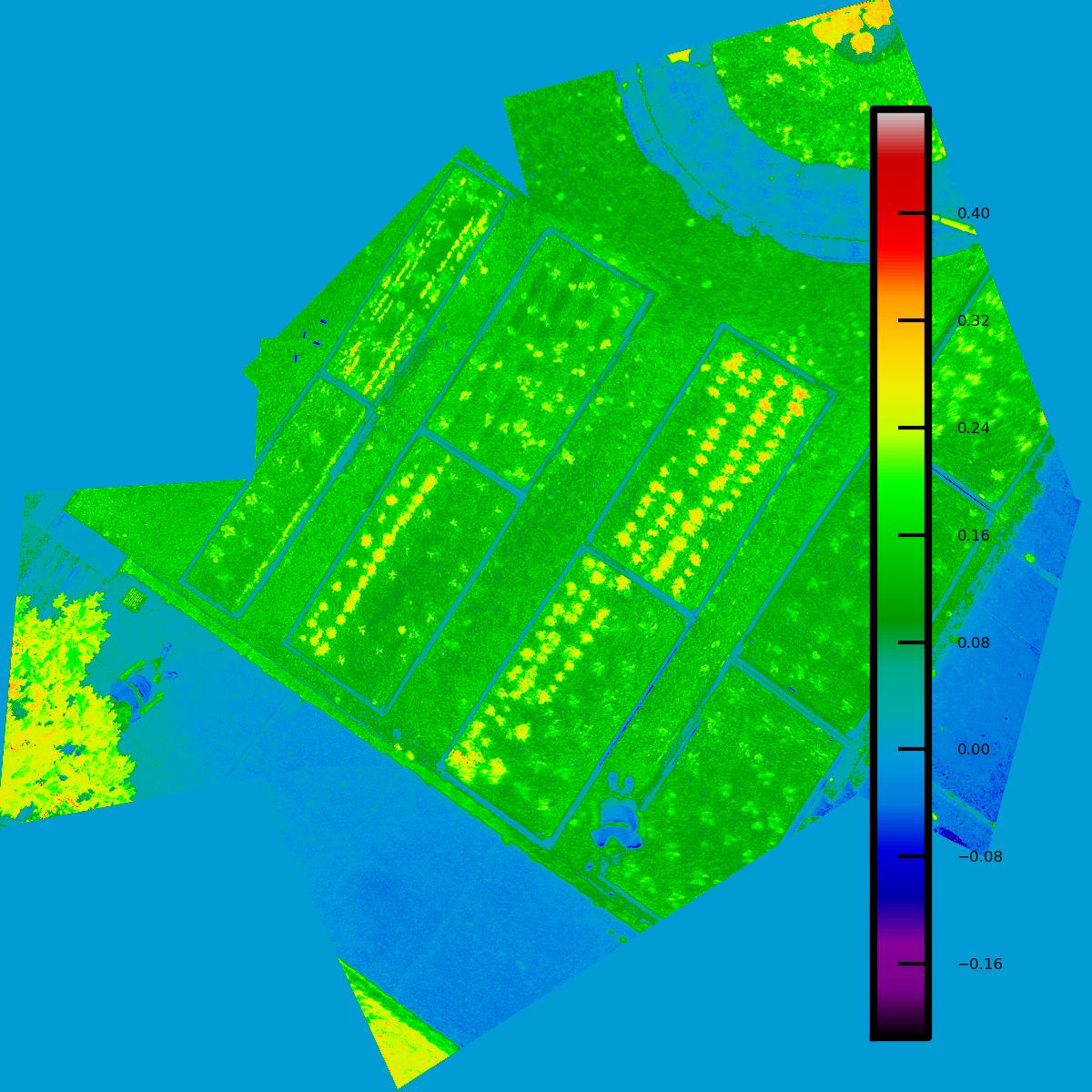
July 2013 - Infragram pole aerial map of DOE Fund Garden, upper Manhattan. (photo by Liz Barry)
The results were anything but predictable. While some gardeners set out to measure the basics—how many pounds of vegetables they grow or gallons of compost they produce—others grappled with concepts that were, on the whole, much more complex. How much volunteer effort goes into a garden? How does a garden lift the spirits of a neighborhood? Can gardens change the way kids think about eating healthy foods? What skills and knowledge does the garden community have to offer?
Site visits featured pole aerial photography and an Infragram to document photosynthetic activity in garden beds. Using a 40’ long lightweight fishing pole made of carbon-graphite means that a single aerial photo can capture the width of a narrow urban lot, making a small scale site documentations a “snap” ;-)
http://publiclab.org/tag/5BF
by Phil Silva and Liz Barry
**Published originally in 2013** [Grassroots Mapping Forum #4.](http://publiclab.org/forum)
[Order a copy or subscribe online.](http://store.publiclab.org/products/grassroots-mapping-forum-issue-4) Only $15/year!
It probably comes as no surprise to read that good things are happening in the hundreds of community gardens throughout NYC and beyond. From growing fresh veggies to composting kitchen scraps to providing city dwellers with beautiful public spaces, these gardens do lot of heavy lifting with little help from city government. But just how much of an impact are these gardens having on quality of life in the city? How do gardeners know if they’ve succeeded in changing their little corner of the urban environment?
Over the summer, gardeners across the city set out to measure some of the outcomes of their work with help from Five Borough Farm, an initiative aimed at supporting urban agriculture in New York. Public Lab co-founder Liz Barry, along with longtime collaborator Philip Silva, worked with gardeners to develop a toolkit of methods for measuring the impacts of an eclectic mix of activities. We began with a daylong workshop giving gardeners a chance to craft their own approaches to collecting data on the impacts of their work.
[](https://i.publiclab.org/system/images/photos/000/008/990/original/DOE-Fund-stitch1_small-original-NDVI.jpg)
_July 2013 - Infragram pole aerial map of DOE Fund Garden, upper Manhattan. (photo by Liz Barry)_
The results were anything but predictable. While some gardeners set out to measure the basics—how many pounds of vegetables they grow or gallons of compost they produce—others grappled with concepts that were, on the whole, much more complex. How much volunteer effort goes into a garden? How does a garden lift the spirits of a neighborhood? Can gardens change the way kids think about eating healthy foods? What skills and knowledge does the garden community have to offer?
Site visits featured pole aerial photography and an Infragram to document photosynthetic activity in garden beds. Using a 40’ long lightweight fishing pole made of carbon-graphite means that a single aerial photo can capture the width of a narrow urban lot, making a small scale site documentations a “snap” ;-)
[http://publiclab.org/tag/5BF](http://publiclab.org/tag/5BF)