Public Lab has developed a number of open source software platforms to assist in the collection, analysis, storage, sharing, and conversion of data from our open source tools. The data storage and sharing websites MapKnitter.org, SpectralWorkbench.org, and Infragram.org provide long-term storage for locally produced data, and convert and present that data in open, standard formats which are easy to use for the press, "scientists", and other advocacy groups while providing community researchers with a forum to discuss, interpret, and compare their data. For example, activists mapping oil contamination from the BP oil spill and those mapping water pollution in the Gowanus Canal have thoroughly documented their work on the Public Lab platform, publishing research notes as well as embeddable web maps at MapKnitter.org. They have also achieved widespread media attention for their work, as well as, in NYC , a place on the EPA community committee involved in the canal cleanup project. _For more detail, visit https://publiclab.org/software-overview. All codebases are available on Github as linked below; the main Public Lab Github account can be found at https://github.com/publiclab_ **** [](https://i.publiclab.org/system/images/photos/000/002/610/original/mapknitter.png) ###MapKnitter [MapKnitter](https://mapknitter.org) is our oldest codebase, since 2014 has provided a free and open source means to place, rectify, and stitch aerial photographs together; in particular those collected using Public Lab's open hardware Balloon Mapping Kit. Users upload images one by one onto a base reference map, and align them in a web-based GIS system. Completed maps are exported into standard formats including TMS, GeoTiff and more. https://github.com/publiclab/mapknitter/ **** 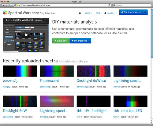 ###Spectral Workbench [SpectralWorkbench.org](http://SpectralWorkbench.org) hosts an archive of open source spectra collected with Public Lab's open source spectrometer. The website enables collaboration to refine and improve sample collection and analysis techniques to identify a growing number of materials. We imagine eventually hosting a comprehensive open library which can help to investigate chemical spills, diagnose crop diseases, and identify contaminants in household products. https://github.com/jywarren/spectral-workbench/ ****  ###Infragram.org [Infragram.org](http://infragram.org), our newest open source codebase, provides real-time multispectral image compositing for crop and vegetation analysis, as well as hosting of resulting open source images for the Public Lab collaborative research community. Users can upload images for analysis or even directly connect modified multispectral cameras and composite live video. https://github.com/p-v-o-s/infragram-js/ ****  ###PublicLab.org The online research sharing platform we’ve created at [PublicLab.org](http://publiclab.org) provides a powerful -- and free -- means for local groups to publish and promote their work, and supports their advocacy by helping to organize events, coordinate data collection, storage, publication, and outreach. https://github.com/publiclab/plots2/ **High priority issues:** https://github.com/publiclab/plots2/issues?labels=priority&page=1&state=open ...
| Author | Comment | Last activity | Moderation | ||
|---|---|---|---|---|---|
| mathew | "How to address Chris's concerns on imagery adding/editing/sharing seems like a tough nut to crack. Is there any way to overlay different mapknitte..." | Read more » | over 9 years ago | |||
| warren | "ooh yeah, lock by default is nice. Basically an extra interaction to put the image in edit mode would be great. " | Read more » | over 9 years ago | |||
| mathew | "I really dig the sidebar concept, full screen map, and loading straight to the edit screen! I agree with Liz, this differs from a Wiki in the cruc..." | Read more » | over 9 years ago | |||
| warren | "Oh sorry, Justin - do you mean the part about But those two views will never change unless edited or deleted by the person who saved them. For th..." | Read more » | over 9 years ago | |||
| warren | "Yeah that's pretty much it -- and if you don't want what other people have added to a given area (an area you're working in, say) you can display o..." | Read more » | over 9 years ago | |||
| justinmanley | "Hmmmm. That's not at all what I had understood from Jeff's comments. Jeff? Could you clarify? " | Read more » | over 9 years ago | |||
| cfastie | "I think (hope) Jeff is describing something like this: I make a map by carefully aligning photos, writing a description, and annotating it. I save..." | Read more » | over 9 years ago | |||
| justinmanley | "Liz - I see. Sure, I can make annotations deletable only by their owners. Ultimately, though, I really think that annotations should be just as f..." | Read more » | over 9 years ago | |||
| warren | "protect carefully constructed maps from careless interference agreed - it was a relatively crude way to do this and there are better means, for su..." | Read more » | over 9 years ago | |||
| liz | "Ah, that hasn't been in line with previous ideas about annotation permissions. We don't want carefully added annotations to be deletable. Based on ..." | Read more » | over 9 years ago | |||
| justinmanley | "Jeff - I have given some thought to edit history. I think that will be a somewhat substantial upgrade, so it may be outside the scope of my projec..." | Read more » | over 9 years ago | |||
| liz | "are you planning to make annotations editable? " | Read more » | over 9 years ago | |||
| warren | "Also, if you merge your branch in and give people an alternate "beta" interface, we can compare them directly, by using /maps/foo (current version..." | Read more » | over 9 years ago | |||
| warren | "This is so great. Yes, current MapKnitter is a Frankenstein of many changes and revisions over the years. Sweep it clean and make it better! One n..." | Read more » | over 9 years ago | |||
| anishshah101 | "This looks like a really good upgrade. Mapknitter would become really user-friendly if we can do this. " | Read more » | over 9 years ago | |||
| liz | "This is super exciting! I have experienced some of these issues when trying to explain how to use mapknitter. So I totally agree with your observat..." | Read more » | over 9 years ago | |||
| nedhorning | "When I created the images above I scaled the output so and NDVI or DVI values less than 0 were set to 0. To include the full range of possible valu..." | Read more » | almost 10 years ago | |||
| sabinozootec | "The images created on ImageJ/Fiji generate values from -1 to 1, although being in the range from 0 to 1. Creating images as figures 0-1? " | Read more » | almost 10 years ago | |||
| warren | "Awesome, great work Ned! " | Read more » | almost 10 years ago | |||
| patcoyle | "Thanks for all the work you've done on this amazing tool. Nice enhancements, put in context. " | Read more » | almost 10 years ago | |||
| daniedb68 | "JIm, Yes, me too. Also very new to NDVI. I post a Update on the NDVI App soon, which have more LUT comparisions aswell as some examples, and fixes...." | Read more » | almost 10 years ago | |||
| headj | "Danie, thank you for the insight. I will keep learning. I find this area interesting. " | Read more » | almost 10 years ago | |||
| daniedb68 | "Jim Thanks. I'm also in a Learning Curve. But according to what I understand 0.1-0.6 is very green. Plants/vegetation is between 0.2 to 0.8. I migh..." | Read more » | almost 10 years ago | |||
| headj | "Sir, this is very nice tool. I used it with some raw images I took a few years back. I can understand better what I am looking at, grass, sky, tree..." | Read more » | almost 10 years ago |