Public Lab has developed a number of open source software platforms to assist in the collection, analysis, storage, sharing, and conversion of data from our open source tools. The data storage and sharing websites MapKnitter.org, SpectralWorkbench.org, and Infragram.org provide long-term storage for locally produced data, and convert and present that data in open, standard formats which are easy to use for the press, "scientists", and other advocacy groups while providing community researchers with a forum to discuss, interpret, and compare their data. For example, activists mapping oil contamination from the BP oil spill and those mapping water pollution in the Gowanus Canal have thoroughly documented their work on the Public Lab platform, publishing research notes as well as embeddable web maps at MapKnitter.org. They have also achieved widespread media attention for their work, as well as, in NYC , a place on the EPA community committee involved in the canal cleanup project. _For more detail, visit https://publiclab.org/software-overview. All codebases are available on Github as linked below; the main Public Lab Github account can be found at https://github.com/publiclab_ **** [](https://i.publiclab.org/system/images/photos/000/002/610/original/mapknitter.png) ###MapKnitter [MapKnitter](https://mapknitter.org) is our oldest codebase, since 2014 has provided a free and open source means to place, rectify, and stitch aerial photographs together; in particular those collected using Public Lab's open hardware Balloon Mapping Kit. Users upload images one by one onto a base reference map, and align them in a web-based GIS system. Completed maps are exported into standard formats including TMS, GeoTiff and more. https://github.com/publiclab/mapknitter/ **** 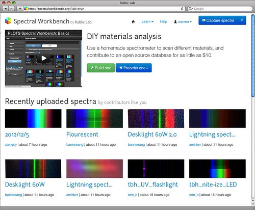 ###Spectral Workbench [SpectralWorkbench.org](http://SpectralWorkbench.org) hosts an archive of open source spectra collected with Public Lab's open source spectrometer. The website enables collaboration to refine and improve sample collection and analysis techniques to identify a growing number of materials. We imagine eventually hosting a comprehensive open library which can help to investigate chemical spills, diagnose crop diseases, and identify contaminants in household products. https://github.com/jywarren/spectral-workbench/ ****  ###Infragram.org [Infragram.org](http://infragram.org), our newest open source codebase, provides real-time multispectral image compositing for crop and vegetation analysis, as well as hosting of resulting open source images for the Public Lab collaborative research community. Users can upload images for analysis or even directly connect modified multispectral cameras and composite live video. https://github.com/p-v-o-s/infragram-js/ ****  ###PublicLab.org The online research sharing platform we’ve created at [PublicLab.org](http://publiclab.org) provides a powerful -- and free -- means for local groups to publish and promote their work, and supports their advocacy by helping to organize events, coordinate data collection, storage, publication, and outreach. https://github.com/publiclab/plots2/ **High priority issues:** https://github.com/publiclab/plots2/issues?labels=priority&page=1&state=open ...
| Author | Comment | Last activity | Moderation | ||
|---|---|---|---|---|---|
| stevie | "Justin! I am SOO excited about this post! These are great reflections and ideas. Let me know if the community development team can help in anyway @..." | Read more » | over 9 years ago | |||
| btbonval | "Justin, this is a great step you've taken. From my own experience with companies that pay me for open source software, there tends to be this disc..." | Read more » | over 9 years ago | |||
| airfix4 | "Thank you. " | Read more » | over 9 years ago | |||
| nedhorning | "At this time it is not possible to use geo-reference data. If there is sufficient interest in that functionality I could try to add it but it's not..." | Read more » | over 9 years ago | |||
| airfix4 | "Hello, I'm new to the organization...and NIR technology in general. I have played some with the Photo-monitoring plug in. Great too by the way! Is ..." | Read more » | over 9 years ago | |||
| theowallis | "Thanks for your reply Chris! " | Read more » | over 9 years ago | |||
| cfastie | "Theo, I have gotten that error too, even when using my own pairs of simultaneous photos (I think the cameras' clocks were way off). I forget what I..." | Read more » | over 9 years ago | |||
| unsignedint | "Hello liz, I think B&W+Green reveals the presence of IR very clearly. The problem is that the intensity is hard to tell, so other color schemes..." | Read more » | over 9 years ago | |||
| theowallis | "Hi I am trying to process two images in Fiji, one raw infrared, one visible spectrum. When choosing the two image files from which to create a tex..." | Read more » | over 9 years ago | |||
| cfastie | "I don’t quite understand how this subtraction would work. When using a red filter, we expect the blue channel to record mostly near infrared light ..." | Read more » | over 9 years ago | |||
| liz | "This B&W and green image is so striking! " | Read more » | over 9 years ago | |||
| nedhorning | "Hi Alan, That sounds good. The first thing your son will realize is that I'm not a very talented programmer. I'm traveling until early next week b..." | Read more » | over 9 years ago | |||
| unsignedint | "Hello Chris! Answering your question What is the "A" in RGBA? Alpha. For this application, it probably does not make any difference whether I pas..." | Read more » | over 9 years ago | |||
| cfastie | "Blender looks to be quite capable. I have some questions about your 3 step process to make the color mapped image: What is the "A" in RGBA? You s..." | Read more » | over 9 years ago | |||
| alanw | "Hi Ned, I have a son who is a pretty good programmer and knows Java. I talked to him and he is seeing if he can use your plugin and add a piece to..." | Read more » | over 9 years ago | |||
| nedhorning | "Hi - At this point the plugin does not subtract the NIR from the red. I've been doing this subtraction as part of my calibration tests: http://publ..." | Read more » | over 9 years ago | |||
| aswicks | "Ned, Using a red filter, does the plugin subtract the blue (NIR) band from the red (red + NIR) to get a red band and then do the NDVI & DVI mat..." | Read more » | over 9 years ago | |||
| warren | "Justin, this is ambitious and super duper. Thanks and I'm excited to see things progress! Commenting has been a need for some time, but do consider..." | Read more » | over 9 years ago | |||
| mathew | "So excellent! I think it is prudent to integrate and streamline the features already spec'ed and leave supermap functionality for another day. " | Read more » | over 9 years ago | |||
| justinmanley | "All - thanks for a really great conversation about the future of MapKnitter. Here's how I've decided to proceed for the time being: I am focusin..." | Read more » | over 9 years ago | |||
| warren | "That has a real nice positive ring to it, mathew, thanks :-) I had actually thought of the Enterprise but was trying to hide my inner nerd. Never ..." | Read more » | over 9 years ago | |||
| mathew | "I agree with Justin's terminology and view plan. a double slider would be ideal for the history: in following Jeff's suggestion, I propose that ..." | Read more » | over 9 years ago | |||
| warren | "Haha, well, the power's in your hands here, Justin, as nobody else is likely to be coding on MapKnitter :-) -- I've definitely not had time in the ..." | Read more » | over 9 years ago | |||
| justinmanley | "It seems like everyone is not on the same page re: Jeff's vision for the future of MapKnitter. Mathew: as I understand it , Jeff is proposing that..." | Read more » | over 9 years ago |