At the end of September I had the pleasure of working with some folks from the Thousand Islands Biological Station (TIBS - http://www.esf.edu/tibs/) which is run by the State University of New York's College of Environmental Science and Forestry. The mission was to do some balloon mapping of wetlands that they are monitoring in and around Clayton, New York. The study site is being monitored to better understand the effects of wetland restoration and enhancement techniques, including channel excavations and water level control structures.
We inflated two 5.5' balloons (from a PLOTS balloon kit) using 60 cubic feet of helium in each. That seemed to be a decent volume for the payloads we were lifting and it happened to be the size of the gas cylinders.

We used a Canon S100 with a built in GPS and a Canon S110 that we flew with a Garmin eTrex GPS and a home-built Arduino GPS logger. Each camera was running a CHDK scrip developed by ESF colleagues to control the shutter interval, focus, shutter speed and ISO speed. Having the GPS built into the S100 was a great convenience. The S100 gave us some problems since it didn't seem to focus properly. The script was designed to set the cameras to focus at infinity but the images were all blurry. It's possible the problem is related to the S100 recall for stuck lenses. The S110, running the same CHDK scrip, produced very crisp photos.

We flew the balloons at an altitude of roughly 200m above the ground. Balloon altitude was determined using a Nikon Forestry Pro laser rangefinder. The altitude changed over time depending on the wind (greater wind speed = lower balloon) but knowing the approximate altitude of the photos and keeping it relatively stable helped in the creation of orthophotos at a resolution that was ideal for interpreting types of vegetation. The first day was nearly wind free but there was a steady breeze on the second day.

At the end of the first day we loaded the balloons on a pickup truck and covered them with a tarp to transport back to the Station. That setup worked well although we were driving 25 miles per hour or slower. We took one of the balloons out to the station (in the middle of the Saint Lawrence River) by boat and stored it in the boat house.


On the second day, just as we were bringing the balloon down the pendulum holding the camera snapped. The shaft of the pendulum was made of aluminum tubing and it snapped in two, apparently from too much bending. My guess is that the camera was swaying back and forth from the wind and also the jerky motion from hauling in the line. The next pendulum I make will use a carbon fiber tube instead of aluminum. Fortunately we had the safety line attached so the camera and GPS didn't fall. The image below was taken before the rod broke.

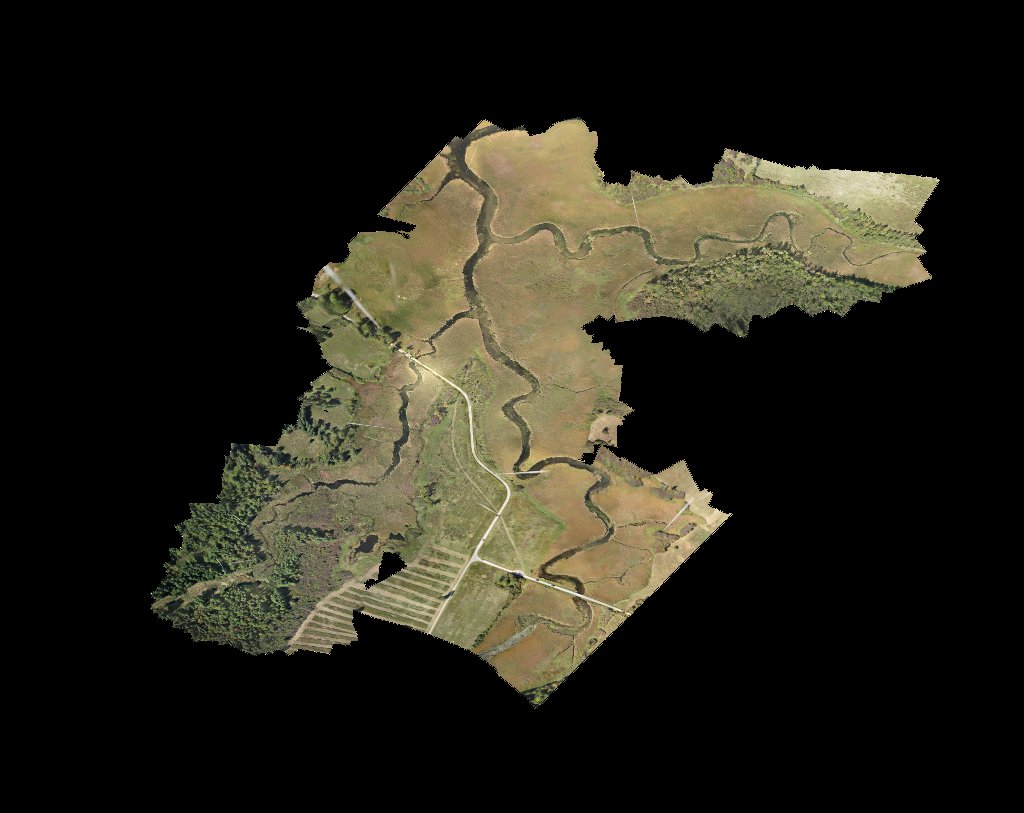
I am using PhotoScan Pro to produce orthophotos from the images and so far the results are quite good. The initial runs were done without adding any ground control points to refine the georeferencing accuracy and no attempt was made to improve the results by tweaking parameters and selecting the best photos. Below are a few examples of the orthomosaics. The first mosaic was created from 660 photos the second was nearly 300 and the island (the research station) was a few dozen.
Thanks to all the folks who helped with the mapping especially the following who are continuing to collect aerial imagery. : Jacob Runner - Senior Research Support Specialist Brandeis Brown - Senior Research Support Specialist Stewart LaPan - Graduate Research Assistant
5 Comments
Ned, Those orthomosaics are terrific. There sure were a lot of canoes on the river that day.
Was the big one made using the GPS data in the EXIF header of the photos? Could Photoscan do it without any GPS data?
The S100 and S110 have good built-in manual control of ISO, shutter, focus, aperture, etc. What was the advantage of using a CHDK script, other than as an intervalometer?
Most importantly, are those channels to the marsh ponds in the second image maintained by otters?
Is this a question? Click here to post it to the Questions page.
Reply to this comment...
Log in to comment
The big mosaic was a combination of three different missions. Two were geotagged using GPS coordinates and the third was just images without any coordinate information. PhotoScan does a good job even without GPS data but the end result will not be geocoded so it won't overlay on a map and it takes longer since the software to do the stitching since it lacks information about how the photos are ordered.
The main advantage for me using a script is that I don't have to worry about forgetting to set something right and everyone will use the same settings. The script still take some tweaking each day depending on lighting conditions so I'm not sure it the benefit is real.
I think those channels were created by Deere and Caterpillars and to some extent are maintained the same way. Maybe one of the ESF folks can chime in with more details on the channel dynamics. That is part of what they're monitoring.
Reply to this comment...
Log in to comment
Very nice results from PhotoScan. Have you used the non-pro version to know how well it does with the autostitching? 600 or 300 images represent a lot of info.
Is this a question? Click here to post it to the Questions page.
Reply to this comment...
Log in to comment
I have not used the non-pro version but it should perform equally well as far as the stitching goes but my understanding is that it won't handle coordinate data so you can't benefit from geotagged photos or output an orthopohoto
Reply to this comment...
Log in to comment
The channels were excavated by the US Fish and Wildlife Service using an aquatic excavator in partnership with the SUNY College of Environmental Science and Forestry, Ducks Unlimited, NOAA, and the NYS Department of Environmental Conservation. The channels were excavated to establish connectivity between the main stem of French Creek and tributaries or potential spawning areas. These meandering channels are believed to enhance fish passage.
Reply to this comment...
Log in to comment
Login to comment.