Here I archive the signature development for human classification of abandoned gravel mines on the Tangipahoa and Amite Rivers in Louisiana. This was published as part of Basics of the Basin in the years after the 2016 flood.
Federal Mine reclamation sidelines gravel mines, and the Louisiana Lege is structured to oppose wetland restoration on mining rivers--Senator Body White, in particular, district 6, commands a district that only includes these areas, and stonewalls any reclamation efforts via agnotological techniques.
Organizations like Nature Conservancy also oppose Mine Reclamation as "too difficult" and politically "impossible." Louisiana Wildlife Federation supports these efforts, but, because Senator Cassidy opposes them, cannot make progress.
And yet, Denham Springs flooded in the 2016 rains because of the loss of Floodplain Forests to gravel mines, costing Louisiana on the order of $10 Billion for that one event.
Gulf Restoration Network attempted to pick up where LDNR abandoned the abandoned mines. Our publications will be referenced in a future research note.
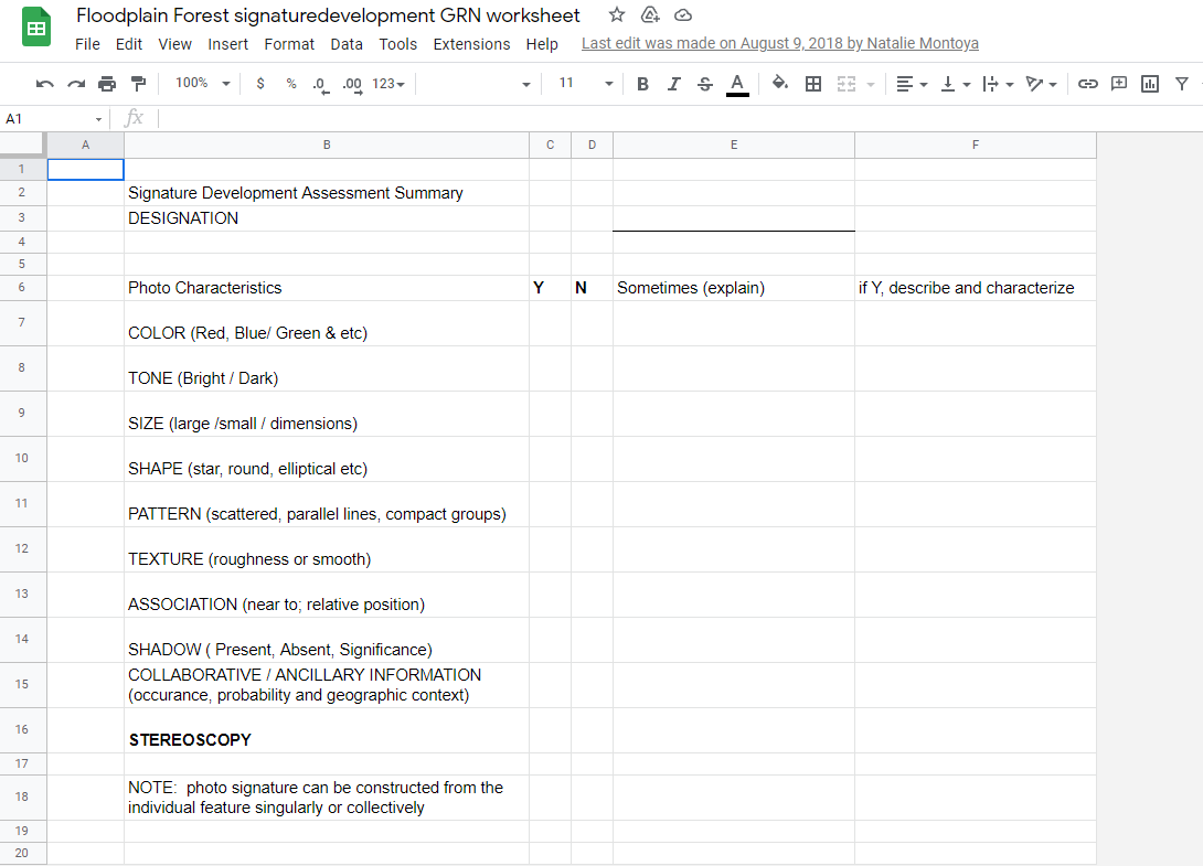
Using techniques developed for the NWI by the National Wetland Research Center in Lafayette, we created Signatures for Classification of Aerial Photography .
Those signatures are recorded here:
Floodplain Forest signaturedevelopment GRN worksheet (Rev August 2018)
https://docs.google.com/spreadsheets/d/15r8sB8WRAq2M3R1cmpm04jQH5FCYgv8fWnAG3eoxZUw/edit#gid=3
A Public Template is here:
Public Copy 2018 GRN Signature Development Assessment Summary for Aerial Photo Classification
The description is as follows:
| RULES |
14 Comments
Floodplain_Forest_signaturedevelopment_GRN_worksheet-FF_Welch_003_Shrubs.pdf
Attached are three Signatures developed by Maya Welsh for GRN.
Floodplain_Forest_signaturedevelopment_GRN_worksheet-FF_Welch_001_Pits.pdf
Floodplain_Forest_signaturedevelopment_GRN_worksheet-FF_Welch_002_Spoil_Piles.pdf
Reply to this comment...
Log in to comment
Here are the csvs that were to be put into a GIS.
No signature development was completed for the GIS fields by Montoya, or perhaps the file has been lost.
CSV
CSV
There are two csvs in the earlier post
One csv for Tangipahoa, one csv for Amite River.
Reply to this comment...
Log in to comment
This is an awesome resource @eustatic , especially for our current RAR on mine reclamation! Really appreciate your explanation of the classification system. Any way you could share GIS screen grabs or any maps made from the csvs to help visualize?
Is this a question? Click here to post it to the Questions page.
yes, but there are buried on a GIS Archive somewhere
Reply to this comment...
Log in to comment
https://www.flickr.com/photos/healthygulf/tags/mines
these photos show a pit capture. the blue line is our canoe path
Is this a question? Click here to post it to the Questions page.
Reply to this comment...
Log in to comment
https://drive.google.com/file/d/1LqzPObDTaKTAfkotuPhh-skMfU5eupLW/view?usp=sharing
Is this a question? Click here to post it to the Questions page.
ppt https://docs.google.com/presentation/d/1l-M6xKOSc1lrq5F3OAz2iGDbZ2yKqpIkRBZY95AMnqA/edit#slide=id.g3483485c21_0_49
Is this a question? Click here to post it to the Questions page.
Is this a question? Click here to post it to the Questions page.
Is this a question? Click here to post it to the Questions page.
https://docs.google.com/presentation/d/1l-M6xKOSc1lrq5F3OAz2iGDbZ2yKqpIkRBZY95AMnqA/edit#slide=id.g38f404e1aa_0_66
Is this a question? Click here to post it to the Questions page.
Is this a question? Click here to post it to the Questions page.
Reply to this comment...
Log in to comment
Login to comment.