What I want to do
Since 2012, Public Lab Gulf Coast has been keeping an eye on one of the emerging cut through Bohemia Spillway, which busted through to make Mardi Gras Pass in Feb 2013.
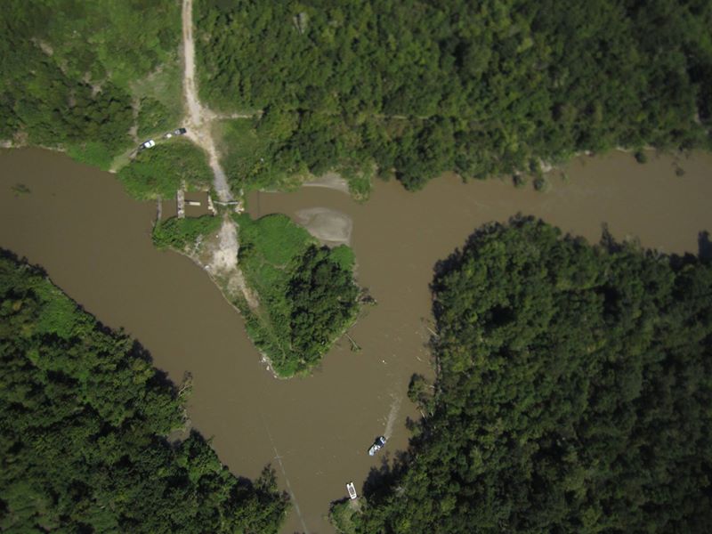
Mardi Gras Pass is a new arm of the river on east bank Plaquemines, ~river mile 55 or so, River Left. This past August was the first 'lowering' water period after the very long flood stage of 2015, and sediment is still flowing from the river into the marshes; but there's new scour, new trees down, and new sediment deposited--basically a lot of activity to document by aerial photography.
We've been monitoring this area since 2012, monitoring the evolution of this channel, which I think is a result of the Gulf rising, the marshes being destroyed, and the lower river filling in and backing up over the last 20 years. There are efforts to plug this new arm of the river, which are based on opposing assumptions --that this new channel is a very short term phenomenon.
The channel ranges from 5-37 feet, based on reports, and it's pretty fast, it was pushing the boat backwards. we purposefully waited until after the flood for safety and mapping purposes.
LPBF is issuing biweekly CFS rates and trends for all river outlets like this on the east bank and in the birdsfoot
s Mardi Gras Pass = 5,091 to 5,300 cfs Aug 10th to 15th, but dropped to about 2000 cfs give or take by the time of our survey.
A full evolution of flow rates is here
Regardless, I hope that pictures can shed light on the public debate, and encourage the study of the evolution of this channel!
My attempt and results
Our infrared camera ran out of memory, which was a bummer.

new scour hole since last LPBF report, in Power line ROW. Power lines replaced.

actual Pass into the River, scoured Feb 2012
Questions and next steps

quick and dirty channel widening since jan 2015
Mardi gras pass, a new arm of the Mississippi, has gotten stronger and definitely gotten a lot bigger. It has sister scour holes: areas downriver that could channelize one day. The LDNR has permitted it to be plugged. The engineering to plug the Pass, and the road (the thing Sundown really wants to plug) is way out of date. It will likely take the armoring of the entire bank over Bohemia. The Sundown Road is broken in several places, and perhaps new, braided passes will develop from these other scour spots.
Next up is to document the other spots, so that landowners and oil companies cannot argue that this unique happening should be closed down.
Richie has also requested that the Bayou Lamoque braided channel gates be mapped--they have been vandalized or taken apart in the past, and money might be spent to restore flow.
It would be useful to run the back channel, and map the wetland growth John Lopez has found, and the wetland resilience claimed by land managers behind Bayou Lamoque.
Why I'm interested
Although this event is fascinating from a scientific point of view, it has been caught up in natural resource management conflict over Caernarvon diversion, as well as the poor opinion of landowners who access the land and who lease their mineral rights to Sundown Energy.
1 Comments
old bohemia post http://publiclaboratory.org/notes/eustatic/4-9-2012/bohemia-spillway-kite-photos
Reply to this comment...
Log in to comment
Login to comment.