This is an interview by Shannon Dosemagen of Eymund Diegel from Grassroots Mapping Issue #4. buy a copy here.
Can you tell me how you got interested in the work being done at the Gowanus, and what personally motivated you to get involved?
I live here and the Gowanus Canal is my backyard. Public Lab tools make it easier to explore that backyard. I like understanding what I see out my window. Like most New Yorkers, I’m also an immigrant, so I really like learning what’s new about this place I’ve come to - that means finding out about its history and clues to what its future might be. The Gowanus is a very polluted place, so it affects us as residents physically. Because I live so close to it and take children out canoeing on it, I would like it to be less polluted. I live on an island surrounded by water, and I think that water could be a lot better quality than it is. My proximity creates a physical incentive to improve it.

Can you explain what kind of work you’ve done at the Gowanus? What have you been looking for?
Well, I’m a local parent so I’ll get schoolteachers asking me if I have any resources on local history: where the Indians used to live, where the battles were fought. I work with Proteus Gowanus, a local cultural group, and we collect the memories and recollections that people have of their landscape and that includes people, books, maps and stories. We make the Gowanus digital archive available to visitors who want to find out about Brooklyn and this particular neighborhood. My professional background is water planning and environmental management so I have a particular fascination with the water that’s shaped cities. Public Lab tools allows me to do a lot of “Do-It-Yourself” specialized research finding out where all the stream beds and old ponds were, how the landscape has changed—to try and understand all those different layers by peeling them back. With the Dredgers, the local canoe club, we are mainly trying to increase connections to the canal and to make it more physically accessible by creating the canoe launches and gardens at the ends of waterfront streets. The idea is that if people touch their environment, they care about their environment, and this helps to move people out of the digital world and back into the physical world they can change. I help out with the Canal Conservancy because I’m fascinated by plants and how they survive in cities and create green jungles. The Conservancy has been tackling the issue of how to make human environments more pleasant for not just humans, but a whole range of different species. We’re doing a mapping project that is a systematic inventory of all the forms of life within a mile of where we are. This makes us appreciate that it’s not just humans here.
Are there any “hidden gems” in the Gowanus area?
The water itself is the biggest hidden gem. For so many years, residents were cut off from the waterfront by industry and never thought of water as a space. A lot of people are really surprised that we have a shoreline and that its water hides a history of our grandparents’ actions - a history that goes really far back. One of the plants you’ll see growing on the sides of the Canal is called the Empress Tree, a Chinese, purple flowering tree also called Paulownia. Its seed pods were used for packing porcelain from China – the seeds were the styrofoam of its day. The seed pods fell out of crates and now you have this glorious tree from 17th century trade growing in 2013 Brooklyn. People go and get married there now and stand beneath these trees. The old buildings themselves are fascinating, we have all this fabulous industrial architecture that a lot of us have lost touch with because our things are made in solid state factories in India and China and you can’t actually see how things are made. But now there’s a whole local craft revival here of people wanting to make things again in these abandoned industrial spaces. That’s another surprise when you walk around the Canal. It may look abandoned, but when you walk inside, there are all these workshops of people doing really cool things, even if it’s just for entertainment, a MakerBot 3D printer factory, or an art collective or a Shakespeare reading. Like walking down a dark street and suddenly there is a lit door and in the lit door there is a whole world going on.
Would you say that simultaneous with a push for environmental restoration is also a very deep connection being built between the environment and economics of this area?
There is. I mean, the environmental restoration happens by itself to a certain degree. The industry leaves and the activity slows down and things grow again and the pollutants are still there but they disperse and some stay there for a long time. People are moving back to the cities because they want more sustainable lifestyles – this means that there is demographic pressure to create a healthier environment in areas like the Gowanus. A lot of the polluted site clean-ups are very much driven by more people wanting to use the space actively.

Can you discuss how you’ve been using aerial imagery in the work that you’ve done at Gowanus?
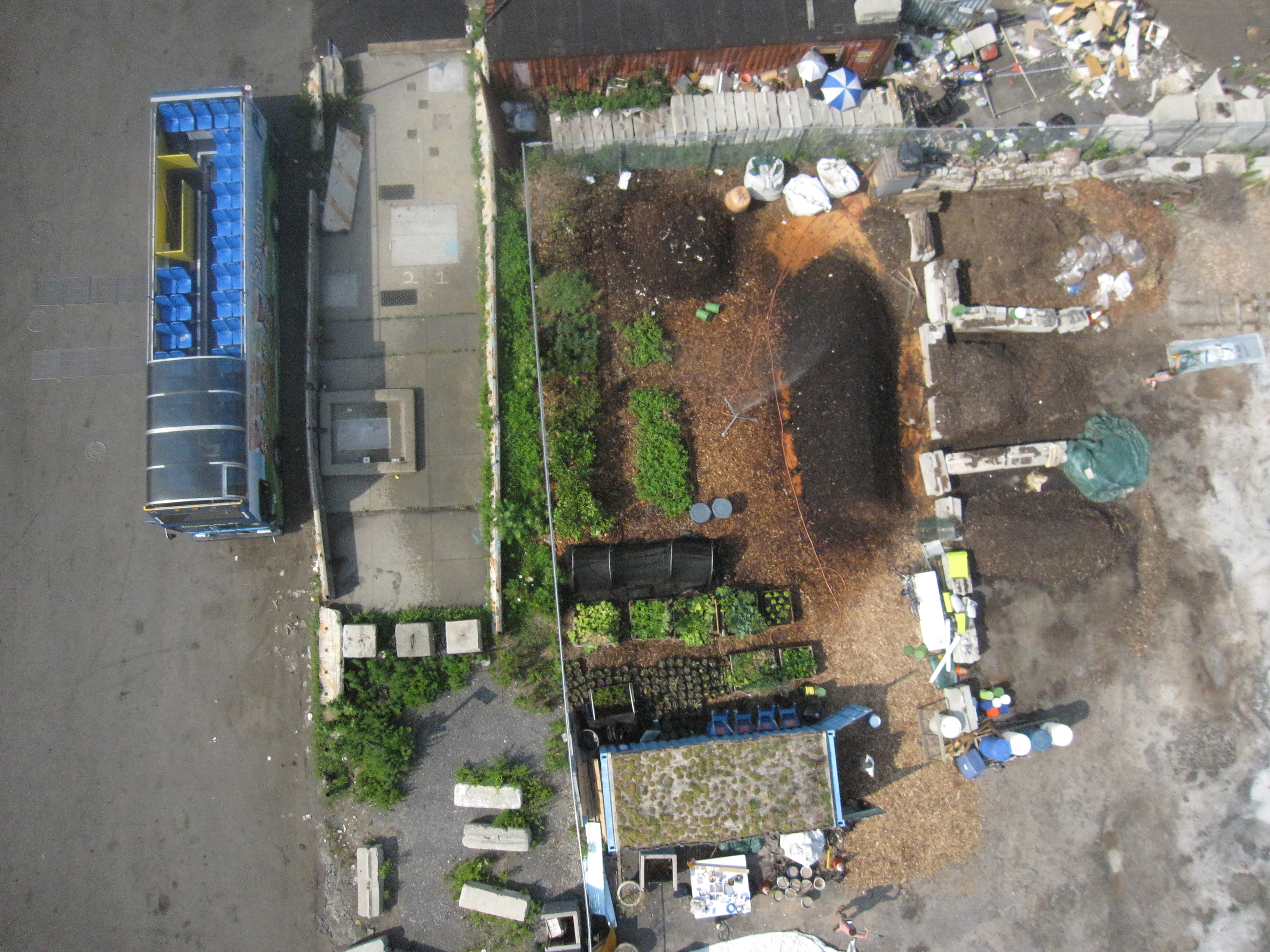
Working with the Gowanus Conservancy the initial driver was to create a record of the restoration plantings that we were doing, catching the four seasons of work where we would plant something in spring and look at how it was surviving during summer and then in a year, whether it was alive. That would inform whether we had made good or bad choices. But then looking at the photographs, we realized it was six times better resolution than anything that the state or the city could provide and that we could get high quality imagery of all the changes that had happened in the last six months. The images became useful for analyzing sites they were targeting for actions. So the grassroots mapping effectively moved from being a recording to a planning and strategic tool, An example I can use is our photographs of concrete parking lots. Some photos had patterns of weeds growing through the breaks in the concrete, very distinctive patterns, and when we tried to understand why that happened by overlaying historical maps, we realized there was an old stream bed and a spring right in the location where all the weeds were growing. We went to look for the spring, and we realized that the spring was still flowing. So, what was a blank area of concrete in the photograph became a strategic piece of green information that we could go to the city with to discuss how they are rebuilding the storm sewers in our neighborhood. We can say “listen, there is a spring here that is still flowing, and instead of putting a storm sewer in the highest and driest part of the land, why don’t we daylight this old stream bed and meet some of the environmental goals that you have: we can create ecological habitat restoration opportunities.” That’s an example of the specialized insight that came out of a cheap, high-technology Do-It-Yourself tool. This is the one of the key things about Public Lab tools, the tools are less important than the process of using them. As we use them, we become curious and by being curious, we start asking questions and a whole conversation gets started that leads to “what should it be?” and “what more could we find out about the site that will help change what we want to change?” . A success story from last July’s “Over My Dead Body” mapping project. was a concrete slab from an old burnt out factory building. A local historian told us that this was a 1776 revolutionary war burial site. We took a bright red balloon and went to photograph the slab, and Liz laid down on it to show what a body would look like lying there. When we looked at the photographs over coffee, we saw these patterns and cracks crossing the slab that exactly matched the patterns and proportions of a mass grave burial ground. Whether it was there or not, the fact that we started talking about it, attracting the attention of a newspaper reporter from the New York Times, led to a whole media hullabaloo about the site being a military burial ground: America’s First Cemetery. Then politicians got involved and now there’s a conversation going on to create a commemorative park that will be a net benefit for the community in terms of additional open space.

The Gowanus Canal is a designated EPA Superfund site. Could you talk a bit about the Superfund process and how generating your own data has been helpful in advocacy work that you’ve done? How has being involved as a local stakeholder made a difference?
The Community Advisory Group (CAG), is a network of community neighborhood associations facilitated by the Environmental Protection Agency. These community groups have a wide range of political opinions—some are pro-development, some are anti-development, some represent industrial interests. Basically, as a coalition, they get together and air their priorities. More importantly, they advocate for cleaning up and provide specialized insight that outsiders don’t have. The “locals” have been staring at the backyard for so long that we know exactly where the rain causes floods; we know where there are the funny stains showing up in the water. So the community advisory process is really where the little old lady in the rocking chair can say “oh I remember this is what happened there” and that insight can suddenly become a clue to finding out exactly why water is the strange color that it is. We had several decades of dumping along the canal where people welded steel plates over concealed outflows so a factory could discreetly dump waste into the canal. Using canoes with balloon-mounted cameras to take aerial photographs we noticed unusual patterns of the water – they displayed that there was something coming from what looked like a wall. We could then put a dot on the map and provide that to the Superfund planners. Although the Superfund Investigation engineers had done a systematic visual inventory of all the outflows, they had missed quite a few of them for the legitimate reason that you couldn’t see them with a naked eye. The Superfund Community Advisory Group process is really about collecting all those examples of local backyard knowledge and then collecting them all on the table and putting the dots together to get an overall picture of the elephant and not leave people just talking about one leg. That’s part of what the advisory group is doing, trying to give community feedback and knowledge to the State and then translating the State’s specialists’ findings back to the broader community. We are trying to reconnect the state with itself because we’re taxpayers, we’re citizens, and we’re working together to create better decision making for running the city.
Could you give some recommendations to people that may be working at a Superfund site? What are some of the successes you had when trying to form the CAG? What was the process? How successful has it been to work with the Superfund process?
There have been pros and cons because you have to work with bureaucracies that have to function by prescribed codes. But those bureaucracies are also trying to take advantage of things that make them look good and it’s successful inasmuch as we provide imagery or ideas or concepts that can reflect well on their process. One of the things that I always try and do is make sure that we do stuff in a fun, congenial way, such as getting kids to hold the balloons that are taking pictures of the issues the Superfund Investigation missed. We’re not saying “hey you missed something.” We’re saying “here’s additional information that we found out and we’re feeding that back in and really trying to be an asset to the process rather than an adversary.” We focus all the time on what’s the real deliverable we’re contributing. We’re looking at specific ideas that can help move the process forward – such as day-lighting the local historic stream rather than paying five times as much money to build a sewer tank in the wrong place.
One of the things that you mentioned is being an asset rather than an adversary. Can you talk about bureaucracies such as the EPA and local government… how they responded to contributions from people around the Gowanus area? Has it been positive? What are some of the challenges that you’ve had?
Overall it has been positive because they’re realizing that we want specific things. One example is that they are planning to make the canal slightly narrower in the Superfund cleanup process because they’re going to have to build impermeable barriers to prevent pollution from the upland areas. Under NY State and US Water Law, they’re going to have to compensate for the lost open water they remove by creating additional wetlands elsewhere. Technically that could happen anywhere in the city. We’re an industrial neighborhood, you wouldn’t think we’re suitable for wetland restoration projects, but in the example of the buried spring that I gave earlier, we pointed out that there is a flowing spring in a landfilled side basin that is filled with circuit boards and toxic waste. The State could do two things at once: remove the pollution and meet their legal wetland requirement. Rather than having the rebuilt wetland go elsewhere, we could have a valuable habitat within five minutes of our schools that will be an asset to the educational process. There have been challenges with not getting as much as we’d like. For instance, there’s a bit of a tug of war going on right now between the CAG and the federal planners as to how much of the upland areas should be dealt with under the federal authority. The Superfund process only deals with cleaning out the water. The upland areas, which are where the bulk of the pollution is, remain under the jurisdiction of the NY State brownfields program—traditionally less energetic in their clean-ups than the federal government. NY state asked the federal US EPA to come and deal with the water because they felt it was too complex for them to deal with. We’d like to see much more of an integrated watershed process, where the whole of the contaminated Gowanus site is treated holistically. The CAG partners have continuously brought this issue up, and we’ve seen a slow change in the dialogue. In the last two months, they’ve actually changed one of the upland strategies where a site that was formally going to be under the State jurisdiction, Thomas Green Park, is now going to be under much closer remediation control by the federal government. We’re actually getting hopeful about a more thorough cleanup as a result.
What are your future plans at Gowanus? What do you specifically hope to see happen there?
We hope it’s going to all get better and there are very real steps in that direction. We just visited the rebuilt Flushing Tunnel, which is a big infrastructure improvement that NYC is building to bring fresh water to the canal. Within the next year we’re hoping to see a 300% improvement to water quality. A lot of the fish and bird life is going to start coming back in the next 12 months. We’re also hoping to get momentum going for the redevelopment of the canal. Some people want development, other people would like to have it stay the way it is – we need to find the balance. The moment you clean something up, people want to build beautiful condos. We need the advocacy of the private sector, and the developers are going to a lot of the physical heavy lifting, but we also want to maintain a sustainable community where people who are on fixed incomes or are renting aren’t pushed out. So there’s that kind of balance that will have to be taken care of. In terms of other projects, we will continue to take high-resolution imagery of the entire canal, like doing aerial photography for a sustainable yards project with local students who are helping the city analyze the rain permeability of the urban landscape. With this data, we can help calibrate the City’s Green Infrastructure plan to understand how much water flows into the sewer and storm pipes. If the City computer model says such and such and our grassroots balloon photographs say oh no, it’s such and such, then it’s a higher resolution refinement of public data to get more accurate results for everyone. Our other main area of work is moving beyond the canal and into the watershed. First, we will be doing more detailed mapping of the 5th street basin, a connector corridor to some of the park systems that are further upslope, and a critical link to get the green streets system connected to the revitalized waterfront. We’re looking for a holistic public access and recreation waterfront plan where people can move around the landscape in a way that’s pleasant. Second, the really fun project that we’re working on this summer is called the Play Pumps Project. The “Play Pump” is an idea from Africa, where rainwater is stored in underground cisterns, and kids playing on Merry-go-rounds pump the water up. We can use this idea here in our watershed for detaining storm water in cisterns before it floods into the sewer system and causes stinky overflows into the canal. The Play Pumps project stems out of our own advocacy success: the CAG kept saying “we want sewage stopped” and the federal planners said “ok, well how about this, we build two big sewer retention tanks next to the canal, so any sewage instead of going into the canal is going to go into the big tanks.” Not a bad idea, but when you look at it more closely you realize that there could be more sustainable alternatives with a lighter footprint, because building a huge concrete sewer holding tank next to the waterfront definitely affects what that waterfront is going to look like. The Play Pumps project is a more refined alternative. We’re studying having lots of smaller rain tanks that are built under school playgrounds further up slope on the watershed. By keeping rainwater out of the sewers, we eliminate the need for the sewage overflow tanks.. This project will give grade school children big sticks of chalk and have them mark out where their favorite play spots are on their playgrounds. We’ll explain the whole concept of play pumps, watershed management and reducing sewage pollution. Then the kids send up the bright red balloons with cameras and chalk out on their playgrounds what they think their Merry-Go-Round should look like, and where other improvements should happen. In that process, we hope to get a dialogue going about what the cheaper ways of managing urban storm water locally are and how playgrounds could be more fun. Images of kids with big red balloons photographing their playgrounds and discussing merry-go-round pumps and green infrastructure solutions make for good press. We actually have high hopes for that particular mapping project. That’s the type of community dialogue we’re hoping to encourage.
Anything else you want to add?
Key thing is that we have to do things that are fun. We’re all overworked and have so much to do and one of the most important things is to make something that people enjoy. That’s what is great about the kites and balloons and kids running around. We’re not just talking about a technique, but lifestyle, a way to reconnect with your neighbors and share what you know.
0 Comments
Login to comment.