GrassrootsMappingBelizeFeb21
(copied from Pat Coyle's entries in the Grassroots Mapping Wiki)
On February 21st, I made my first attempt to try the camera and GPS unit. I pulled the camera up into a cut-off 2 liter soda bottle and attached the small GPS unit on top of the soda bottle. I hooked it on the end of the broom handle and tried it outside in the front yard.
 |
| From New Album 2/22/10 8:15 PM |
 |
| From New Album 2/22/10 8:15 PM |
 |
| From New Album 2/22/10 8:15 PM |
 |
| From New Album 2/22/10 8:15 PM |
There were several observations.
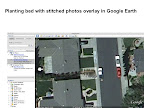
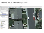
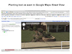
I realize I have a lot to learn to be able to efficiently stitch a set of photos and then rectify the overall composite image. I finally ended up hand-stitching some test images in PhotoShop Elements and just overlaid the image in Google Earth and annotated the screen shots shown above.
It was awkward to activate the script when the camera was tucked up inside the bottle. It was hard to reach the buttons to go through the sequence of enabling the script to run. I noticed in the video with Jeff, it looks like he had the camera out, actuated it, and then pulled it up into the housing.
- It was awkward to secure the camera with strings (and wrist strap) at the top rim or lip of the soda bottle (goes with number 1 above).
- The lines from the bottle top rim or lip (two lines, with half -hitch around the rim on either side) up to the point of connection didn't seem to make for the best straight down orientation of the package.
- I still need to consider options for attaching to balloons and to the line. I used a braided Dacron 80-pound-test fishing line. It's nice, but pretty slick or slippery. Maybe a different line or cord combination at the balloons and connection to the package is preferred. I need a detail on connecting to the line.
- The camera script ran for a while (took about 40 photos), then the camera shut off. I'm not sure why. The battery seemed fresh. I wouldn't want this to happen during a real flight.
- Afterwards, I noticed that I hadn't gotten the camera time set properly. I had to fiddle around with time corrections in \HoudaGeo and My Tracks until I finally was able to sync up the photos with the GPS tracks. I also noticed that the tracks on Google Earth appeared to be shifted across the front yard over towards the driveway. Maybe that's just within the GPS accuracy.