
I wanted to share some thoughts that became clearer to me now, a month or so after the barn raising gathering (Oct 2013), in which these issues were discussed by some of us. The bottom line of what I am about to share here is that I realized that the challenge I face now in order to make the work I've been pulling through in Jerusalem more significant for the communities I am working with, is dealing with the problem of design. To say it more clearly - community engagement ends right where the need for design begins.
The decoder is the insider
What I am talking about relates specifically to grassroots-mapping using DIY aerial photography tools, but I am sure this can be as true with other open tech and DIY tools and methods. The basic premise is that aerial photographs do not speak for themselves. And in particular those made by communities. Exactly like any other form of photography aerial images are ground for interpretation, rather than for objective decoding. The well established ideas and professional practice of “decoding” aerials is based on and perpetuates patterns of exclusion. S/he who's trained to decode is an insider by definition, a professional in the service of powerful interests. I know this is not knew for you, Jeff Warren and Public Lab did a lot for developing an annotation tool that can be quite useful for storytelling. But I think digital annotation is only one aspect of what we need to do for re-shaping the aerial for community storytelling and making it more accessible and engaging tool for triggering change.

above: east-providence-pond-view-map, mapknitter.org
The story of the Road
A friend of mine has been an aerial photography decoder for the Israeli army during her obligatory years of serving as a soldier (between the age of 18-20). She learnt the skills needed during her service, and she recalls that what she was supposed to produce for her commanders at the time, was to create what was called in military jargon “Sipur Derekh”, Hebrew for “the story of the road”. Her mission was to find the best way for soldiers to cross through a land they didn't know, mostly during night-time, for the purpose of take-over. Through the “Sipur Derekh” she constructed, the soldiers had to be able to know the area as good as a local person does. She used to hover, fly, above the aerial images, cross-examining the same place by using aerials taken at different times. It involved a great deal of imaginative work, juxtaposing clues on the natural features with traces of human activity and life in the place. She particularly mentions the huge gap between her imaginative flight above the area and the extreme reduction of the 'Sipur Derekh' she had to construct and pass on.
mapping the unseen
As I see it, what we, as grassroots-mappers, are looking to do is to invert this power to take-over – which is today being exercised in all sorts of ways (ranging from war and conflict through urban planning and the industries' environmental damages). The story of our road, contrary to reducing the meanings of an aerial image in the service of a narrow interest, is one that seeks to reveal social and environmental context through collaborative mapping. It is not only about an objective reality to be visualized and decoded, but about mapping and thus seeing the subjective story that is embedded in and is inseparable from the concrete features of geography.
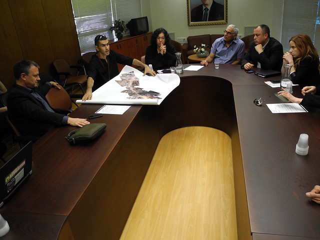
above: Ala Salman who created an aerial map of a contested road that splits his neighborhood in two and damages its environmental and communal infrastructures, presents his DIY aerial image to MP's in the Israeli "Kneset".
stand by its side - give it voice and knowledge
The people I was working with had a story to tell on top of that aerial photograph they created. They re-appropriated 'the master's tool', the same tool that is being used in order to erase their presence and identity off the map, or to rationalize plans for destruction and regeneration in the city that ignores their local perspectives. They have created aerial photography in Silwan, Beit Safafa or in Ein Karem, but they had to stand, physically, right beside it to give it their voice and knowledge. The questions that arise once they leave the aerial by itself into the offline and online streams of information, is who will it reach, what story will it tell, or as Catherine D'ignazio phrased it nice and simply “where do our maps go?”.

growing a long tail for mapmaking
In our ethics and politics discussion during barn raising, Liz Barry was mentioning that we need to think of the long tail of community engagement in open-tech and support the local groups we are working with, towards meaningful change. As I said in the beginning, what became clear to me is that we have to work on developing this long tail, which I think raises problems of design in visualizing information. In Silwan we created this integrated poster map that included text and photos the children we worked with created, but we had to have a designer to do that cause the task of turning all this information into a coherent and attractive poster was too complex. Looking at the poster we produced one can see that we have a lot more to learn - and on that note - here is an excellent and inspiring guide for visualizing information for advocacy.
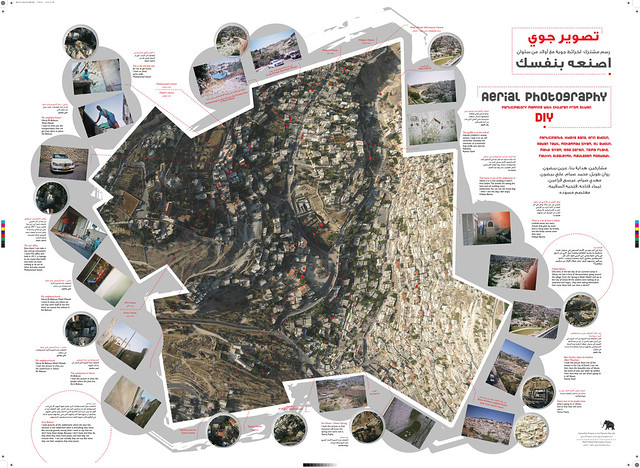
above: Annotated aerial map of Silwan created by children living in the village (East Jerusalem)
re-shaping the aerial
But why should open tech end when it gets to questions of design? Can we think of a workflow that would enable local groups to go beyond creating the object itself, the aerial photograph, to a process of re-shaping the aerial image? I imagine re-shaping its uses, meanings and appearances in everyday life both online and offline. Especially when talking about community engagement we want to create a movement between offline, analog activities to online and digitally-based engagements.
don't just stand by - step on it, jump on it, draw on in
I imagine it not only as a post-production activity but as a public event. Maybe we need to think about prototyping machines and sensors that allow to annotate in public space by anyone who passes-by, by stepping on the image, writing and drawing on it, and turning these bodily actions to digital input that can be later be ground for online engagement.
where do we go from here?
This is to share my thoughts with you at this point in time, hope to attract the interest of some of you to continue this further. I think that once we will be able to create a workflow for telling a story using DIY aerial photography, these community-based maps would be useful not only for advocacy and representation, but also in wider range of everyday uses. Namely, for navigating in the actual geography, in quite a different way than conventional maps allow us today, from the point of view of its inhabitants. Not taking-over that point of view, but embracing it.

above: click the photo for a close-up, to read a detail of children's annotations on the DIY Silwan aerial map.
4 Comments
Hi Hagit,
I enjoyed viewing your video and reading this note. I haven't put much thought into a generic work flow. From my limited experience the goals and constraints around each project are different enough that people tend to craft a custom work flow using different tools and techniques for a particular project. There are quite a few guides and case studies related to community mapping but I don't recall seeing anything that's as creative as what you are thinking about.
I have a possible social/community mapping project on the horizon so I've been trying to catch up on recent progress in that area. The objective of the project would be to use maps and other spatial resources to improve the way we incorporate human/cultural input into the conservation planning process. I'm not sure of the best way to foster a discussion about this but I'm interested in hearing more about your and other peoples' ideas. I have reasonable experience with the technical/mechanical aspects but am not all that strong when it comes to the creative bits.
Reply to this comment...
Log in to comment
Hi Ned, I am happy to know there is interest and technical/mechanical aspects is definitely what I am missing :) would be great to learn more on the context of what you do in conservation planning process and see how we can continue this discussion further. Do you have some research notes on this? btw, in terms of human-cultural input to conservation, this might be a bit far off, but do you know this work by Jerome Lewis and the Extreme Citizen Science people in UCL, on Pygmies monitoring logging activities and other damages to wild life and forests in Congo: http://uclexcites.wordpress.com/2013/06/18/participatory-mapping-in-congo-brazzaville-part-1/
Is this a question? Click here to post it to the Questions page.
Reply to this comment...
Log in to comment
Hi Hagit,
I don't have any research notes related to community mapping. Most of my involvement is peripheral, providing input into methods and helping with data collection protocols and image mapping. The project we are developing will try to go beyond the more traditional practice of developing conservation priorities primarily using bio-physical data and largely ignoring human land use and values or assuming they could be modified to fit the conservation goals. The specific goals and objectives for this project are still being worked out.
My “toolbox” of community mapping ideas largely comes from work other folks are doing. I put some guides/case studies on my ftp site: ftp://ftp.amnh.org/pub/people/horning/ParticipatoryMapping. You might be familiar with many of these documents but I point you to them so you have an idea of my, largely “in the box”, perspective of community mapping.
I am not familiar with the UCL Congo project but it looks similar to other projects I'm familiar with. That project isn't that far off. I was supposed to be in the DRC (the other Congo) at this time helping with a community forest project but I couldn't fit it into my schedule.
Reply to this comment...
Log in to comment
Hi Hagit,
Thanks for the great post.
I am a graphic/media designer first and a mapper second but from my limited knowledge I can point that there have been multiple gestures within the design world to address the particular questions you are posing. Iconoclasistas have a guide out for Collective Mapping and, in my opinion, what is incredibly useful about their workflow is the use of icons to mark different activities on the map. Some icons are self explanatory others are a bit more ambitious (human trafficking and gentrification), but the map becomes both process and final design-report like artifact. This may allow the communities to be the ones directly "speaking".
Their Collective Mapping manual in english http://www.iconoclasistas.net/2012/10/25/cuadernillo-de-mapeo-colectivo-en-ingles/
I would also check the work being done by the Center of Urban Pedagogy http://welcometocup.org/
I agree with Ned that a work-flow for all cases might not be the best route to go since the needs of each particular project are different. Also the constrains and affordances. However, we have to be careful not through our media intervention create representations that are even more alienating in their form than relevant to the community.
From my personal experience during a community mapping project in Uganda I explored a similar process as what you are suggesting to the post-production activity as a public event. Long story short (for full story see http://publiclab.org/notes/mlamadrid/05-15-2013/tool-for-stalling-mapping) the group I was working with was getting evicted and we were struggling with visibility. I had brought with me a lot of different sensors and speculated on multiple ways of actually embedding story-telling devices on the dirt. First I wanted to build a seed like device that would tell stories of the community once the Ministry of Tourism came to visit the site. Later it was more about the device surviving the actual destruction of the houses. In both instances, when people stepped on it they could hear sounds from the market.
But while it would have created an interesting and probably compelling way of presenting the information, there were some problems with this idea. First it became apparent that it was not only a matter of visibility but of applying pressure through journalism. The Ministry knew the community was there but the land was worth way more than the community needs. So we created interventions that actually counted on news outlets documenting them (http://www.mlamadrid.com/Tools-for-Stalling-Eviction-Animal-Barricade). Second, the sensor devices had no relevance to the community I was working with and worst, potentially alienated them in the process of creating it. It would have been me, as a media designer, geeking out.
Community Mapping talks about the idea of returning the tools of control back to people so they can invert the power dynamics. However, there are already instances in the process where the communities forgo their participatory role, like the process of stitching the map once they have collected the pictures. This is why MapKnitter is great. While still not as refine as putting together the map with Photoshop, it does allow pretty much anyone to take over the part of knitting the map.
I guess my argument is, that when thinking of post-production, while it has to definitely utilize strategies that appeal to the taste of the MPs and the state, we have to be careful not through our media intervention create representations that are even more alienating in their form than relevant to the community.
There is also this interesting project by Beograd Gazela called Travel Guide to a Slum, that provides essential information about the social and economic structures of the area slum through a semi-ironic Travel Guide for tourist and government officials. However I don't remember if Gazela actually took government officials through the slum using this guide. Which would have made for a really interesting intervention.
Sorry for the long comment but hope this helps.
Reply to this comment...
Log in to comment
Login to comment.